Sunday, June 4, 2017

Gulf of Mexico Tropical Moisture Brings Heavy Rain Threat to the South, Including Drought-Suffering Florida

Chris Dolce
Published: June 4,2017

Tropical moisture surging north from the Gulf of Mexico will continue to result in heavy downpours across parts of the South, Gulf Coast and into drought-stricken Florida early this week.
Some of the moisture in the Gulf of Mexico is associated with the remnants of Tropical Storm Beatriz, which hit the Pacific coast of Mexico late last week.
(MORE: Beatriz Causes Deadly Flooding in Mexico)
We do not expect a tropical depression or storm to develop in the Gulf of Mexico, however, as upper-level winds are too strong. The National Hurricane Center said the area of low pressure associated with Beatriz's remnants had a near-zero-percent chance of development as of Sunday afternoon.

Heavy Rain, Flash Flood Threat This Week

There's a host of ingredients in play to raise the flash flood threat early this week in the South.
1) A deep flow of tropical moisture pushing toward the Gulf Coast
2) A slow-moving upper-level low moving from Texas through the Deep South adding instability to the atmosphere
3) An arriving frontal boundary, providing a focus to lift the warm, humid air
4) A sharp jet stream plunge into the East, which may induce an area of low pressure to form along the front, further focusing heavy rain
The ingredients in play this week for heavy rain along the Gulf Coast and Florida.
Repeated rounds of locally heavy rainfall are possible through midweek from the upper Texas coast to the Florida Peninsula.
With the ground already saturated over much of the northern Gulf Coast, the threat of flash flooding there is high.

Current Radar, Watches and Warnings
(MORE: Flooding Nearly Three Times Deadlier in 2015-2016)
Some spots in Florida had already seen 3 to 6 inches of rainfall through Friday, including the Orlando and Miami areas. Additional rounds of rain and thunderstorms are expected through midweek, adding to the rainfall totals.
The chance of additional showers and thunderstorms will continue through late week in the Florida Peninsula as a frontal boundary stalls over the state. The rest of the South will begin to dry out.

Rainfall Potential Through Friday
This setup will bring the potential for significant rainfall, especially along the west coast of Florida and throughout the Gulf Coast, into midweek. A widespread area of more than 3 inches of additional rain is likely in central and southern Florida through this week, with locally more than 6 inches. Isolated areas along the Gulf Coast will also see high rainfall totals early this week.
Tampa, Florida, could see its heaviest rain since before Labor Day 2016.
(MORE: Why Florida Has Wet & Dry Seasons)
While some flooding is possible in the Florida Peninsula and southern Georgia this week, this rain is also desperately needed, given the current severe to extreme drought and recent wildfires.
(MAPS: 7-Day U.S. Daily Forecast | 48-Hour Rainfall Forecast)
MORE: Atlantic Basin's Retired Hurricane and Tropical Storm Names


The Weather Company’s primary journalistic mission is to report on breaking weather news, the environment and the importance of science to our lives. This story does not necessarily represent the position of our parent company, IBM.

This Date in Weather History for June 4,2017 from weatherforyou.com

Weather History
For Sunday,June 4,2017


1825 - A hurricane struck Long Island NY leveling trees and causing damage to ships. The early season hurricane, which originated around Cuba, caused major damage along the Atlantic coast from Charleston SC to New York City. Many were lost at sea. (David Ludlum)
1860 - Iowa's Commanche Tornado , with wind speeds estimated in excess of 300 mph, was unquestionably one of the worst experienced by early settlers, with nearly a million dollars damage. (The Weather Channel)
1982 - A four day storm began over New England which produced up to 14 inches of rain in southern Connecticut breaching twenty-three dams and breaking two others. Damage was estimated at more than 276 million dollars. (David Ludlum)
1987 - Early morning thunderstorms in south Texas produced 6.5 inches of rain at Hockheim, and five inches at Hallettsville, in just a few hours. Afternoon thunderstorms in Virginia deluged northern Halifax County with 5.5 inches of rain in two hours. Thunderstorms produced wind gusts to 76 mph at Dusty WA, and wind gusts to 88 mph at Swanquarter NC. (The National Weather Summary) (Storm Data)
1988 - A dozen cities in the eastern U.S. reported record low temp- eratures for the date, including Atlantic City NJ with a reading of 40 degrees. Fifteen cities in the north central U.S. reported record high temperatures for the date, including Glasgow MT and Havre MT with readings of 102 degrees. (The National Weather Summary)
1989 - Thunderstorms produced severe weather from the Southern Plains Region and the Lower Mississippi Valley to the Southern Atlantic Coast Region during the day and into the night. Just four tornadoes were reported, but there were 87 reports of large hail and damaging winds. (The National Weather Summary) (Storm Data)

This Date in Weather History for June 3,2017 from weatherforyou.com

Weather History
For Saturday,June 3,2017


1921 - A cloudburst near Pikes Peak CO killed 120 people. Pueblo CO was flooded by a twenty-five foot crest of the Arkansas River, killing 70 persons. Fourteen inches of rain was reported at Boggs Flat, where a hard surface road through nearly level country was washed out to a depth of seven feet. (The Weather Channel)
1959 - Thunderstorms in northwestern Kansas produced up to eighteen inches of hail near Salden during the early evening. Crops were completely destroyed, and total damage from the storm was about half a million dollars. Hail fell for a record eighty-five minutes. The temperature dropped from near 80 degrees prior to the storm to 38 degrees at the height of the storm. (David Ludlum)
1987 - Six days of flooding in South Texas culminated with five to six inch rains from Bexar County to Bandera County, and five to nine inches rains in Gonzalez and Wilson Counties. Total crop damage was estimated at 500 million dollars. (Storm Data) (The National Weather Summary)
1988 - Early morning thunderstorms in southern Texas produced wind gusts to 86 mph at Port Isabel, and wind gusts to 83 mph at South Padre Island. Unseasonably hot weather prevailed from the Southern Plateau Region to the Northern High Plains. Fourteen cities reported record high temperatures for the date. (Storm Data) (The National Weather Summary)
1989 - Thunderstorms developing over the Southern Plains Region during the afternoon hours produced severe weather into the night. Thunderstorms spawned eleven tornadoes, and there were 169 reports of large hail and damaging winds. Thunderstorm winds gusted to 80 mph at Newcastle, OK, and Wilson, OK. Softball size hail was reported at Monahans, Childress and Groesbeck TX. Monahans TX reported six million dollars damage. Five inches of rain deluged Geronimo OK. (The National Weather Summary) (Storm Data)

Friday, June 2, 2017

Thundery showers to disrupt UK outdoor plans this weekend


By Kristina Pydynowski, AccuWeather senior meteorologist
June 2,2017, 12:41:50PM,EDT
 
 
After heavy thunderstorms soaked southeastern England on Friday, an unsettled weekend puts numerous outdoor plans in jeopardy across more of the United Kingdom.
Thundery showers erupted across southeastern England on Friday as a cold front swept eastward.
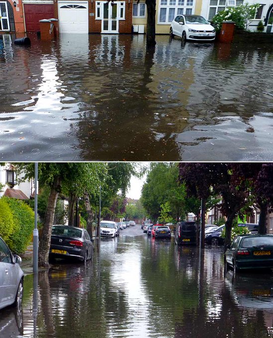
Localised flash flooding resulted with London Fire Brigade reporting more than 60 flood-related calls on Friday afternoon.
monsoon floods, whilst the weather forecast did talk of thunderstorms & torrential rain, this was exceptional!
On the heels of the downpours, a depression churning over the northern Atlantic Ocean will keep the U.K. unsettled with showery spells this weekend.
Whilst the entire weekend will not be a washout and there will be breaks of sunshine, showers threaten to disrupt outdoor plans at anytime on Saturday and Sunday across the northern and western U.K.
Some of the showers will turn thundery, forcing anyone outside to seek shelter for a time. As soon as thunder is heard, the risk of being struck by lightning is present.
RELATED:
United Kingdom interactive radar
Check AccuWeather MinuteCast® for your location
World Meteorological Organization announces global records for deadliest weather events in history

Wellies and ponchos will be needed by those planning to attend the Great Women’s Run in Glasgow on Sunday.
London and the rest of southeastern England are expected to escape the wet weather on Saturday with sunny spells returning. If any showers reach these areas, it would not be until Saturday evening.
A dry start to Sunday will follow, allowing anyone heading to church services to leave brollies at home. Those with outdoor plans on Sunday afternoon will be less fortunate as showers are expected to close out the weekend.
UK Weekend June 2
The unsettled weather pattern will prevent warmth from returning to the U.K. this weekend.
Temperatures will be fairly typical of early June, ranging from 14-17 C (58-63 F) in the north and west and 19-21 C (66-69 F) in the southeast on Saturday. Temperatures will be held slightly lower on Sunday.
Residents of the U.K. are likely to be using their brollies frequently next week as bouts of wet weather persist. Monday's depression may be potent enough to produce locally flooding rain and gusty winds.

Germany to face new round of severe weather on Saturday


By Eric Leister, AccuWeather meteorologist
By Kristina Pydynowski, AccuWeather senior meteorologist
June 2,2017, 12:19:14PM,EDT
 
 
A new round of severe weather will threaten Germany on Saturday after violent thunderstorms rattled the country on Tuesday.
Hail, flooding and damaging winds were all reported across Germany on Tuesday before drier and more comfortable conditions filtered in at midweek.
Warmth and humidity will once again set the stage for more thunderstorms to ignite on Saturday.
Germany June 2

After heavy thunderstorms erupted over southwestern Germany on Friday, AccuWeather Meteorologist Tyler Roys is concerned for more numerous severe thunderstorms to target the country on Saturday.
The main area of concern lies from Hanover to Stuttgart. Frankfurt, Nuremberg, Saarbrücken and Freiburg are other cities at risk.
The severe weather is expected to remain west of Berlin.
"The strongest thunderstorms will occur in the afternoon," Roys said, "and the biggest threat will be flash flooding followed by small hail and damaging winds. There is a very small chance for a tornado."
RELATED:
Germany Weather Center
MinuteCast® for your location
Interactive Germany weather radar

The thunderstorms will be fueled by the warmth that will send temperatures soaring to 25-28 C (77-82 F) across central and southern Germany on Saturday. Highs of 21-24 C (70-75 F) will be more common in northern Germany, including Hamburg.
The severe thunderstorms will diminish across central Germany on Saturday evening, but rain and thunderstorms will linger over eastern and southern areas into Sunday morning.
Breaks of afternoon sunshine will replace the wet start to the day in Berlin, while showers keep communities near the Alps damp throughout the day.
An unsettled weather pattern will linger across Germany into early next week leading to additional rounds of showers and thunderstorms. A turn to warmer weather may follow around next Wednesday and Thursday.
 

Heavy, gusty storms to roll across northeastern US from Sunday to Monday


By Alex Sosnowski, AccuWeather senior meteorologist
June 2,2017, 2:43:11PM,EDT
 
 
Storms that erupt from the lower Great Lakes Sunday to the Interstate 95 corridor of the northeastern United States on Monday can pack a punch for travelers and outdoor activities.
In most cases, the best bet for outdoor plans and projects will be the first part of the weekend.
A vigorous storm system that will trigger locally heavy, gusty thunderstorms over the Upper Midwest into Saturday night will spin across the Northeast by the first part of next week.
People should keep an eye out for changing weather conditions as they travel on the highway, attend ballgames or spend a day fishing on the lake. The downpours and gusty winds can occur with little notice.
"During Sunday afternoon and evening, thunderstorms from western and central New York to western and northern Pennsylvania, Ohio, Indiana, southeastern Michigan and southern Ontario will produce torrential downpours, localized damaging wind gusts and perhaps hail," according to AccuWeather Senior Meteorologist Brian Wimer.
Static Sunday Strong Storms 3 pm

A batch of drenching rain and thunder will develop over eastern New York state and push across New England to close out the weekend.
Meanwhile, areas from Portland, Maine, and Boston to New York City, Philadelphia, Baltimore and Washington, D.C., can expect most of the weekend to be dry. Some rain may fall late Sunday afternoon and evening.
"During Monday, areas from southeastern New York state to Virginia will be in the zone where torrential downpours can strike and the stronger storms could produce localized damaging wind gusts and perhaps hail," Wimer said.
Static Heavy Storms Monday 3 pm

Areas from the eastern Great Lakes to the Appalachians are likely to be hit by multiple showers and/or thunderstorms on Monday.
In a few extreme cases, thunderstorm winds can be strong enough to break tree limbs and cause sporadic power outages during Sunday and Monday.
Since many streams are running high in the area, there will be the risk of localized flash flooding. The rain can come down hard enough and fast enough to overwhelm storm drains and result in incidents of urban flooding.
RELATED:
AccuWeather Severe Weather Center
What Trump's decision to pull out of the Paris Climate Agreement means for the US
Weekly wrap-up: Rare, intense storm kills 16 in Moscow; Cyclone Mora batters Bangladesh, Myanmar

Airline passengers should be prepared for delays, especially during the afternoon and early-evening hours, when the storms will be at their strongest level.
While the storm system will make steady progress across the Midwest, it is likely to stall in the Northeast during much of next week.
Static US Early Next Week

As a result, each day from Tuesday to Thursday will bring multiple rounds of showers and thunderstorms.
 

Major flooding engulfs Taipei as storm unleashes over 150 mm of rain in Taiwan


By Kristina Pydynowski, AccuWeather senior meteorologist
June 2,2017, 11:52:36AM,EDT
 
 
One person is dead after moisture from former-Tropical Cyclone Mora led to quick-hitting torrential rainfall and major flooding in northern Taiwan on Friday.
Extreme rainfall in excess of 150 mm (6 inches) was unleashed in a matter of hours.
Out of the 163 mm (6.42 inches) of rain that inundated Taipei on Friday, 120 mm (4.72 inches) fell in just two hours, according to data obtained by Taiwan’s Central Weather Bureau.
Northern parts of New Taipei City were hit the hardest with rain totals exceeding 300 mm (12 inches).

Sanzhi District has topped Friday's rainfall totals list with 645.5 mm (25.41 inches).
“The majority of that rain occurred with a 12-hour period,” AccuWeather Meteorologist Adam Douty said.
Flooding quickly swamped the area and turned streets into rivers, including in Taipei. Flooded tracks disrupted rail traffic.
One woman was killed when she was swept away by the flood waters while riding a motorcycle in the Bali District of New Taipei City, Taiwan News reported. Two other people are missing.
Schools and universities were forced to close. Flood waters inundated Boling Kindergarten in Taipei, forcing students and staff to evacuate to a nearby building.
Some schools are expected to remain closed into Saturday.
Taiwan rain totals June 2
The far northern tip of Taiwan joined the central mountains in enduring the most extreme rainfall totals on Friday. (Image courtesy of the Central Weather Bureau)
More than 300 flights were delayed at Taiwan’s Taoyuan International Airport on Friday, according to FlightAware.
“Moisture from what was once Tropical Cyclone Mora moved along the Mei-yu front across southeastern China and Taiwan, leading to the very heavy rainfall,” Douty said.
“The Mei-yu front is a semi-stationary boundary that forms during the late spring and summer across southeastern Asia.”
This front is notorious for triggering torrential rainfall, Douty added.
Douty expects additional rounds of rainfall along the front to exacerbate the flood risk into this weekend.
RELATED:
Taiwan weather center
Detailed forecast for Taipei City
2017 Asia summer forecast: Heat to roast northeastern China, Japan; Typhoons to hit Philippines to Vietnam

“While the heaviest rain has likely fallen, additional rainfall through Sunday may be heavy with over 100 mm (4 inches) likely in some areas of Taiwan,” he said.
The heaviest downpours are likely to focus on southern Taiwan on Saturday before spreading back to the north on Sunday.
"Taipei may catch a break on Saturday with only lighter and more isolated showers and thunderstorms," Douty said. "However, more numerous downpours may return to end the weekend and could drop an additional 25-50 mm (1-2 inches)."
Taiwan June 2
Heavier rain will threaten the surrounding mountains.
Any substantial rain will trigger new or worsen ongoing flooding, putting more lives and property at risk. Roads and bridges can be damaged, while already swollen rivers may further rise out of their banks.
Never walk or drive across a flooded road or bridge as the roadway underneath may be washed away or the current below the surface may be unsuspectingly flowing dangerously too fast.
A mere 300 mm (12 inches) of fast-flowing water can sweep away a small car.
The risk of downpours across Taiwan will lessen early next week.

Weekly wrap-up: Rare, intense storm kills 16 in Moscow; Cyclone Mora batters Bangladesh, Myanmar


By Katy Galimberti, AccuWeather staff writer
June 2,2017, 12:08:13PM,EDT
 
 A violent storm swept through Moscow on Monday, killing at least 16 and wounding more than 200.
The storm is the deadliest to hit the Russian capital since 1998. Wind gusts of 95-110 km/h (59-68 mph) were reported across the city of more than 12 million people. Moscow’s mayor, Sergei Sobyanin, tweeted that 243 buildings were damaged along with around 2,000 automobiles.
Storms of this intensity are rare across Russia.
moscow storm ap
In this Monday, May 29, 2017 photo vehicles are covered with a fallen tree following a storm, in a residential area of Moscow, Russia. (Sergey Vedyashkin/Moscow News Agency photo via AP)

As many as 500,000 people were displaced by the former Cyclone Mora this week. The system lashed Myanmar and Bangladesh with heavy rain and damaging winds on Monday and Tuesday.
At least six people were killed by the cyclone in Bangladesh, according to the BBC.
The cyclone toppled trees and destroyed homes along its path as it tracked from just west of Myanmar into eastern Bangladesh.
BangladeshAP 5/31
Bangladeshis carry their belongings and walk homewards after spending a night at a shelter in Cox's Bazar, Bangladesh, Tuesday, May 30,2017. (AP Photo)

Widespread rainfall of 75-150 mm (3-6 inches) was reported from Myanmar into Bangladesh and northeastern India with local amounts over 300 mm (12 inches) in the higher terrain.
Severe storms wreaked havoc in North Carolina on Monday, injuring more than a dozen people.
At least 10-15 homes were damaged or destroyed, and several barns were also significantly damaged, according to emergency management officials in Sampson County, located in the eastern half of the state.
RELATED:
World Meteorological Organization announces global records for deadliest weather events in history
2017 Atlantic hurricanes to pose threat to southeastern US despite possible onset of weak El Nino
Wounded, stranded animals recuperate after deadly central US tornadoes thanks to caring volunteers

Winds up to 90 mph were responsible for the damage along the storm's path, which extended about five miles wide.
Heavy rain and hail slammed the San Antonio, Texas, area early this week. Flooding ensued, prompting officials to perform several swift-water rescues. Three brothers were swept into Leon Creek, according to the San Antonio Star.
According to a witness, the men were shooting video of the rising water when they were pulled in, San Antonio Police Sgt. Joe McKinney said.
The three men remain missing.
Tropical Storm Beatriz lashed southern Mexico this week, leading to mudslides and flooding. The system made landfall near Puerto Angel on Thursday.
Puerto Angel recorded nearly 10 inches (247 mm) of rain in 24 hours.
Alaska's Bogoslof Volcano erupted on the Aleutian Islands on May 28, sending ash as high as 45,000 feet into the air.
The volcano’s eruption prompted concerns for aircraft safety as ash ejected into the atmosphere can severely impair a plane’s engines. This marks the second time the volcano has erupted this month.
The volcano erupted in mid-May and ash rose to 35,000 feet.
 

Strong storms to blow through Upper Midwest into the weekend

By Faith Eherts, AccuWeather meteorologist
June 2,2017, 3:04:59PM,EDT
 
 
After a period of dry and increasingly warmer weather across the northern Plains and Midwest, unsettled weather is in store for the area into the weekend.
“As cool and warm air masses collide over the Dakotas and Minnesota through Saturday, there will be some thunderstorms crossing these areas,” said AccuWeather Senior Meteorologist Carl Babinski.
A cold front tracking through the area will tap into the surface heat, sparking strong thunderstorms from southeastern Saskatchewan, Canada, into the Nebraska Panhandle into Friday night. Additional storms will erupt in parts of Colorado.
Residents of Bismarck, North Dakota, Rapid City, South Dakota, and Alliance, Nebraska, should prepare for potentially dangerous storms.
“The main concerns include strong, potentially damaging wind gusts and large hail. Hail greater than an inch in diameter is possible,” said Babinski.
Hail of this size would pose a significant threat to agriculture and livestock, as well as cars and property.
Strong winds in any storms will also heighten the risk of toppled trees and power lines.
“Wind gusts in places unimpeded by structures could exceed 70 mph,” said Babinski.
As Friday night progresses, the area of storms will track eastward across the Plains, impacting Grand Forks and Fargo, North Dakota, and Sioux Falls, South Dakota.
Static Strong Storms Saturday Upper Midwest 3 pm

"On Saturday, the most likely areas for strong to briefly severe thunderstorms will extend from northern Iowa and southeastern Minnesota to the Upper Peninsula of Michigan, as well as the western part of the Lower Peninsula of Michigan," according to AccuWeather Senior Meteorologist Alex Sosnowski.
Cities including Minneapolis and Madison and Green Bay, Wisconsin, will be impacted by storms containing sudden torrential downpours and perhaps damaging winds and hail.
Major League Baseball games in Milwaukee and perhaps Chicago scheduled for Saturday afternoon could face delays as storms roll through those areas Saturday through Saturday night.
The system driving these storms is expected to strengthen as it tracks eastward, resulting in a larger temperature drop in the Midwest than across the northern Plains.
RELATED:
Tropical downpours to drench southern US into next week
What Trump's decision to pull out of the Paris Climate Agreement means for the US
World Meteorological Organization announces global records for deadliest weather events in history

Temperatures are expected to persist well above average in the northern Plains in the wake of this cold front, but the frontal passage will bring noticeably cooler weather into the Great Lakes by Monday.
As the system continues to strengthen and move into the Northeast, a period of pleasantly dry and seasonable weather will commence in the Midwest.
 

This Date in Weather History for June 2,2017 from weatherforyou.com

Weather History
For Friday,June 2,2017


1889 - A great flood on the Potomac River in Washington D.C. took out a span of Long Bridge, and flooded streets near the river. The flood stage reached was not again equalled until 1936. (David Ludlum)
1917 - The temperature at Tribune, KS dipped to 30 degrees to establish a state record for the month of June. (The Weather Channel)
1949 - A tornado northeast of Alfalfa OK circled an area one mile in radius. (The Weather Channel)
1985 - Lightning struck a house, broke a bedroom window, and jumped to a metal frame bed. A man was killed but his wife was unharmed by the lightning. (The Weather Channel)
1987 - Thunderstorms spawned seven tornadoes in West Texas and six tornadoes in Illinois. Thunderstorms in Illinois produced wind gusts to 70 mph at McComb and Mattoon. Thunderstorms in southern Texas produced 5.5 inches of rain south of Seguin, and up to eight inches of rain in Washington County. (Storm Data) (The National Weather Summary)
1988 - Severe thunderstorms in Texas and Oklahoma produced hail more than three inches in diameter near Stilwater OK, and softball size hail in Jones County of north central Texas. Baseball size hail and 70 mph winds caused an estimated 100 million dollars damage around Abilene TX. (National Weather Summary) (Storm Data)
1989 - Thunderstorms produced severe weather across much of the south central U.S. through most of the day and night. Thunderstorms spawned a dozen tornadoes, and there were 123 reports of large hail and damaging winds. Thunderstorm winds gusted to 78 mph at Russell KS, and baseball size hail was reported at Denver CO, Cuthbert TX, and in Reeves County TX. Afternoon thunderstorms in southern New England produced wind gusts to 120 mph at Fitchburg, MA, causing five million dollars damage. (The National Weather Summary) (Storm Data)

Thursday, June 1, 2017

Tropical downpours to drench southern US into next week

By Alex Sosnowski, AccuWeather senior meteorologist
June 1,2017, 1:55:17PM,EDT
 
 
People with travel and outdoor plans in the southern United States will have to contend with tropical downpours that could lead to isolated flooding into next week.
While downpours will be scattered throughout the region through this weekend, there will be areas of concentrated rainfall on already saturated ground that will elevate the risk of flooding.
In general, the heaviest rain will fall on the Interstate 10 corridor. However, torrential downpours and isolated flooding problems are likely as far north as I-20 and even part of I-40.
On Saturday, the area at greatest risk for flash, urban and small stream flooding will extend from central Texas and Oklahoma to southwestern Tennessee and Alabama.
Static Saturday Drenching Southern Storms

Cumulative rainfall in parts of the South from the last few days of May to the first few days of June may top 5 inches in many locations and could approach 10 inches in the rainiest spots.
On Sunday, areas from the Big Bend area of Texas to eastern Tennessee and much of Georgia will be in the zone where drenching thunderstorms will be on the prowl.
Static Sunday Drenching Storms

During next week, a press of dry air from the central and northern Plains will impact the pattern of downpours. Drenching rainfall will begin to consolidate along the Gulf coast, before being shunted eastward.
However, this could mean good news for much of Florida, in areas being troubled by wildfires and drought conditions.
RELATED:
AccuWeather Severe Weather Center: Flood advisories
2017 Atlantic hurricanes to pose threat to southeastern US despite possible onset of weak El Nino
Tropical Storm Beatriz threatens to flood southern Mexico

The combination of a weak storm system from the southern Rockies and a batch of tropical moisture originating from the Pacific Ocean may bring general drenching rainfall to Florida during the middle to latter part of next week.
Static Florida Downpours Next Week

"There is a small chance a tropical depression organizes in the southwestern Gulf of Mexico in the coming days," according to AccuWeather Hurricane Expert Dan Kottlowski.
This development be born from the remnants of Beatriz moving inland over southern Mexico from the Pacific.
"Even if a tropical system manages to form, strong winds at mid-levels of the atmosphere will probably prevent full development," Kottlowski said.
Prior to the arrival of the rainstorm or weak tropical system next week, very spotty thunderstorms will erupt during the afternoons, before dissipating in the evenings.
 

Hundreds of thousands displaced as Cyclone Mora causes destruction across Myanmar, Bangladesh

By Eric Leister, AccuWeather meteorologist
June 1,2017, 10:21:46AM,EDT
 
 
More than 500,000 people have been displaced by the former Cyclone Mora which brought heavy rain and damaging winds to western Myanmar and Bangladesh on Monday and Tuesday.
At least six people have been killed by the cyclone in Bangladesh, according to the BBC.
India Today reported that six fishing boats were still missing off the coast of Bangladesh. The boats reportedly contained at least 71 people.
BangladeshAP 5/31
Bangladeshis carry their belongings and walk homewards after spending a night at a shelter in Cox's Bazar, Bangladesh, Tuesday, May 30, 2017. A tropical storm lashed southern Bangladesh on Tuesday, killing at least six people and destroying thousands of poorly built homes in some remote islands in the Bay of Bengal, officials said. (AP Photo)

The cyclone toppled trees and destroyed homes along its path as it tracked from just west of Myanmar into eastern Bangladesh.
The storm then moved into northeastern India where the rugged terrain resulted in the dissipation of the cyclone.
Mora produced wind gusts over 70 mph from Cox’s Bazar to Chittagong on Tuesday morning, local time.
Despite weakening as it moved inland, Mora continued to produce heavy rainfall as it tracked into northeastern India.
India June 1

Widespread rainfall of 75-150 mm (3-6 inches) was reported from Myanmar into Bangladesh and northeastern India with local amounts over 300 mm (12 inches) in the higher terrain.
As some of the more than 500,000 displaced people return home, the full extent of the damage will become more clear.
Despite Mora dissipating, the threat of flooding and mudslides will continue across parts of Bangladesh and northeastern India into this weekend.
Lingering tropical moisture will fuel widespread showers and thunderstorms each day.
RELATED:
Interactive Bay of Bengal weather satellite
Bangladesh Weather Center
Detailed Dhaka weather forecast

Additional rainfall of 50-100 mm (2-4 inches) will be common through Sunday with locally higher amounts.
This rainfall on top of already saturated soil and high river levels will trigger additional flooding and continue the threat for mudslides.
Bangladesh and Myanmar are particularly prone to devastating storm surges due to the highly populated coastal plain which also contains several rivers. This topography along with a high population density has resulted in eight of the top 10 deadliest cyclones in recorded history originating in the Bay of Bengal.

Tropical Storm Beatriz threatens to flood southern Mexico


By Kristina Pydynowski, AccuWeather senior meteorologist
June 1,2017, 1:59:49PM,EDT
 
 
Lives and property will be threatened in southern Mexico as Tropical Storm Beatriz unloads torrential rain late this week.
A tropical low spinning south of Mexico organized into Tropical Depression Two-E on Wednesday morning. The depression was upgraded to Tropical Storm Beatriz on Thursday midday, local time.
“Beatriz may make landfall in the state of Oaxaca between Puerto Angel and Puerto Escondido,” AccuWeather Senior Meteorologist Rob Miller said.
Static Beatriz

Beatriz has churned up seas along the coast of southern Mexico, endangering swimmers and operators of small craft.
“Any wind damage issues would be sporadic and limited to the immediate coast,” Miller said, “but flooding is the main danger and will exist regardless of any strengthening.”
Miller warned of widespread rainfall totals of 150-250 mm (6-10 inches) across Oaxaca late this week. Puerto Angel has been inundated with 163.4 mm (6.44 inches) in the 24 hours ending early on Thursday morning.
"Amounts in excess of 250 mm (10 inches) will also inundate the higher terrain of Oaxaca, especially the southern mountains," he said.
“The torrential rain in southern Mexico threatens to cause life-threatening flooding and mudslides," Miller said.
There can be localized flooding in the states of Chiapas, Tabasco and Veracruz as downpours from the depression spread northward.
RELATED:
AccuWeather eastern Pacific hurricane center
2017 East Pacific hurricane forecast: Warm waters to fuel frequent development of storms
How to avoid drinking contaminated water after a hurricane

After making landfall, the mountains of southern Mexico will cause Beatriz to weaken to a tropical rainstorm, but flooding downpours should remain into Friday.
Downpours may also graze the western Yucatan Peninsula to end the week.
In the Atlantic Basin, where hurricane season officially starts on Thursday, a piece of the tropical system could attempt to re-organize in the southern Gulf of Mexico this weekend.
However, strong winds above the surface over the northern Gulf of Mexico would likely reverse any development and shred the system apart.
Tropical moisture could still get drawn northward and enhance the risk of blinding downpours and local flash flooding in the southern United States this weekend and early next week.

Dry days to be a rarity in the Northeast through next week

By Faith Eherts, AccuWeather meteorologist
June 1,2017, 12:26:19PM,EDT
 
 
The wet weather pattern in the Northeast will continue to plague the region through the coming weekend.
Some areas saw more rainy days than dry ones in May, and this pattern is expected to continue into June.
Following a relatively dry and sunny day on Thursday, the threat of afternoon pop-up showers and storms will increase and spread through Pennsylvania and southern New England while showers linger in northern New England on Friday.
Static Friday NE P. Lang.

While the storms won’t be widespread, they will disrupt any outdoor plans with potentially heavy rain, gusty winds and lightning.
Those in the Midwest can expect drenching rain and storms on Saturday, but it will be another mainly dry day across the Northeast.
“Saturday looks to be the driest day overall, with only central and northern New England standing the risk of a passing shower, with only parts of Maine perhaps seeing a period of steadier rain,” according to AccuWeather Meteorologist Ryan Adamson.
NE unsettled 0601

Those from the Carolinas through Maine who are making plans for the upcoming weekend should limit outdoor activities to Saturday.
This area of wet and dreary weather will shift into the Northeast for Sunday, sticking around through early next week.
“This system will spread to the coast on Sunday night and Monday, making for a wet Monday morning commute along I-95,” said Adamson.
“An area of unsettled weather will sit over the Northeast through the early and middle part of the week, continuing the risk for showers along with some periods of steadier rain.”
RELATED:
Interactive Northeast Radar
AccuWeather Hurricane Center
Are you more prone to sunburn? Dermatologists explain key risk factors

Areas that receive repeated rounds of heavy rainfall from these systems should anticipate flooding from area creeks and rivers. While most river gauges are currently showing no flooding, a few in New York state are already at minor flooding stage.
"In this situation, people should avoid camping along small streams and those camping along unprotected areas of the major rivers should be prepared to move to higher ground," according to AccuWeather Senior Meteorologist Alex Sosnowski.
It will be important for residents to stay up to date on local watches and warnings and to avoid driving through flooded roadways.
While a day or two next week could turn out dry for many, the active weather pattern will continue to send storms through the region into at least the middle of June.

This Date in Weather History for June 1,2017 from weatherforyou.com

Weather History
For Thursday,June 1,2017


1812 - Apple trees at New Haven CT did not blossom until the first of June, the latest such occurrence during the period beginning in 1794. Snow whitened the ground in Cleveland OH and Rochester NY. (David Ludlum)
1903 - A strong tornado just 50 to 75 yards in width killed many persons around the Gainesville GA Cotton Mill. The tornado strengthened and widened near the end of its four mile path, killing 40 persons at New Holland GA. A total of 104 persons were killed in the tornado. (The Weather Channel)
1980 - A man from Falmouth ME was struck by lightning restoring his eyesight. The man had been blind and partially deaf since a truck accident in 1971. (The Weather Channel)
1987 - Severe thunderstorms in the Upper Mississippi Valley and the Lower Ohio Valley produced wind gusts to 81 mph at Albert Lea Airport in southern Minnesota, and baseball size hail around Otterbein IN, Sarona WI, and Danville IL. Two inches of hail totally destroyed 5000 acres of corn and soybean north of Danville. (The National Weather Summary) (Storm Data)
1988 - Thunderstorms drenched north central Texas with torrential rains, with more than 14 inches reported in Commanche County. Afternoon thunderstorm in New Jersey and Pennsylvania produced wind gusts to 70 mph. (The National Weather Summary) (Storm Data)
1989 - Thunderstorms developing during the afternoon over the Southern Plains Region produced severe weather through the evening and the night, spawning nine tornadoes. Thunderstorms produced wind gusts to 80 mph at Alpine TX, and baseball size hail at Balmorhea, TX, Fluvanna, TX, and in Borden County, TX. (Storm Data) (The National Weather Summary)