Friday, November 4, 2016

The Greatest 24-Hour Snowfalls in All 50 States

Chris Dolce
Published: November 3,2016

Snow can pile up several feet in a day's time when conditions are ripe in many U.S. states.
In fact, 48 of 50 states have received more than a foot of snow during a single 24-hour period, according to data from NOAA's National Centers for Environmental Information (NCEI). Of those 50 states, 32 of them – mostly in the West, Midwest and Northeast – have had snowfalls of 30 inches or more in 24 hours.
During those extreme situations, snowfall rates are often an inch or more per hour. Thundersnow also sometimes occurs, an indication of unstable air and strong upward motion in the atmosphere, resulting in heavy snow.
This map illustrates the largest 24-hour snowfall records across the United States, according to NOAA/NCEI.

States With Greatest 24-Hour Snowfall Records

An example of the incredible snow the Valdez, Alaska, area receives. (Marc Lester/Anchorage Daily News/MCT)
Colorado leads the pack with the most extreme 24-hour snowfall record in the Lower 48 states.
If you were 6 feet tall and standing outside for 24 hours in Silver Lake, Colorado, April 14-15, 1921, you would've been buried by snow from head to toe. That location saw 6.3 feet (75.8 inches) of snow high in the Rockies at an elevation of 10,220 feet.
One location in Alaska, however, takes the crown for all 50 states.
Tucked away in the mountains northeast of Valdez, Alaska, is Mile 47 Camp, which was buried by 78 inches of snow in the 24 hours ending Feb. 9, 1963. Here, winter storms in the Gulf of Alaska send moisture from the Pacific into the mountainous terrain, making it an ideal spot for incredible snowfall totals.
(MORE: The World's Deepest Snow)
Three other states have had 24-hour snowfalls exceeding 50 inches, and much like the top two locations, mountainous terrain also played a role in squeezing out those extreme totals.
Those states are California (67 inches in the Sierra Nevada), Washington (65 inches in the Cascades) and South Dakota (52 inches in the Black Hills).

Recent 24-Hour Snowfall Records Broken

Five U.S. states have set new 24-hour snowfall records during the past 10 years.
Cars buried by snow after Winter Storm Nemo near Hartford, Connecticut, on Feb. 10, 2013. (AP Photo/Jessica Hill)
Connecticut is the most recent state to rewrite the record books when a location near Ansonia saw 36 inches Feb. 8-9, 2013. That new benchmark for the state was set during Winter Storm Nemo, which also hammered several other New England states with more than a foot of snow.
About two years earlier, Oklahoma set a new 24-hour snowfall record when 27 inches piled up in Spavinaw Feb. 9-10, 2011.
A single spring blizzard in March 2009 propelled two states to new 24-hour records. Pratt, Kansas, and Follett, Texas, made state history with 30 inches and 25 inches of snow, respectively, in the 24 hours ending March 28, 2009.
(MORE: Snowiest Spot in Each State)
The fifth state to set a new record in the last decade is Nebraska, where 27 inches was measured near Dalton in the 24-hours ending Dec. 21, 2006.

More on 24-Hour Snowfall State Records

Here are some other notables on 24-hour snowfall records in the U.S.
  • Oldest records: The two records that have stood the longest are 36 inches in Astoria, Illinois, during the 24 hours ending Feb. 28, 1900, and 49 inches at Watertown, New York, Nov. 14-15, 1900.
  • Two states with less than a foot in 24 hours: Florida and Hawaii are the only two states with record 24-hour snowfall totals of less than one foot. No official records exist, but Mauna Kea and Mauna Loa on Hawaii's Big Island may have seen a foot or more of snow in 24 hours. Florida's record 24-hour snow was 4 inches near Milton, which oddly occurred in early March 1954.
  • Unofficial higher totals in some states: A few states have unofficial higher snowfall totals not recognized by NOAA. This includes a 55.5 inch total at Alta Guard Station in Utah Jan. 5-6, 1991 and a 54-inch total in New York's Tug Hill plateau in January 1976. Finally, Louisiana's 24-hour total may be higher than the 13 inches NOAA has for the state. Winter storms in February 1898 and December 1929 may have beaten it out, but data from those storms is not reliable.

PHOTOS: Deepest Snow in All 50 States

Rough Weather Sinks Indonesian Ferry; Death Toll Tops 50

Eric Chaney
Published: November 4,2016

More bodies have been recovered after rough weather caused the sinking of a an overcrowded boat off the Indonesian island of Batam earlier this week, raising the death toll to more than 50.
Airlangga, a police spokesman for Riau Islands, which include Batam, told Reuters Friday morning that the latest death toll stands at 54, and six people are still missing.
An Indonesian marine uses binoculars from the deck of a rescue ship during a search operation for dozens of people still missing after an overcrowded speedboat capsized off Batam, Indonesia, Thursday, Nov. 3, 2016.
(AP Photo/M Urip)


There were 101 people, including 3 crew members, on the speedboat carrying migrant workers and their families that capsized amid thunderstorms early Wednesday morning, according to the Associated Press.
“Storms developed Wednesday morning near Batam and again in the afternoon,” said weather.com meteorologist Linda Lam. “Thursday and Friday also saw additional rounds of rain and thunderstorms, especially Thursday night into Friday morning.”
(MORE: Siberia Is Being Clobbered With Snow, Which Could Mean a Harsher U.S. Winter)
Nearly 40 of the passengers were rescued, but the continuing rough weather made rescue efforts difficult, Abdul Hamid, head of the local search and rescue agency told the AP.
"This search is not easy," he said. "Strong winds and currents were hampering our efforts and the sea was murky, making it difficult for rescuers to look below the surface."
Indonesian police officers carry the body of a victim in the capsizing of a speedboat in Batam, Indonesia, Wednesday, Nov. 2, 2016.
(AP Photo/M Urip)
November is the beginning of Indonesia’s wet season, Lam said, and stormy weather lasting days is not at all unusual.The boat was carrying Indonesian workers home from Malaysia, the AP reports, and police suspect the trip was illegal and the workers were undocumented because of the high fares that passengers said they paid.
The boat’s two surviving crew members were later arrested, the AP said.
MORE: 5 Indonesian Volcanoes

After Smashing November Monthly Records, A Breather From the Fall Heat Wave is Arriving

November 4,2016
Only a few hot holdouts in the Deep South and Gulf Coast are left after a fall heat wave smashed not only hundreds of daily records, but also some November monthly records. Heat relief, an odd thing to say in early November, is now moving in.
Thursday, November monthly record highs were tied in Atlanta (84 degrees) and Mobile, Alabama (87 degrees).
Dozens of daily record highs were tied or broken Thursday in the mid-Atlantic and South, including:
  • Memphis, Tennessee (85 degrees)
  • Tupelo, Mississippi (87 degrees)
  • Jackson, Tennessee (87 degrees)
  • Atlantic City, New Jersey (81 degrees)
  • Georgetown, Delaware (83 degrees)
  • Pensacola, Florida (85 degrees)
  • Athens, Georgia (85 degrees)
  • Macon, Georgia (86 degrees)
  • Norfolk, Virginia (83 degrees)
  • Richmond, Virginia (83 degrees)
  • Salisbury, Virginia (82 degrees)
  • Augusta, Georgia (87 degrees)
  • Washington D.C. (83 degrees)
  • Houston (88 degrees)
  • Tallahassee, Florida (88 degrees)
  • Shreveport, Louisiana (86 degrees)
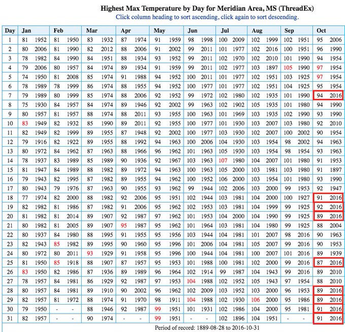
Meridian, Mississippi, extended its streak of daily record highs tied or set to seven straight days Thursday.

Current Temperatures
This continues what has been a much warmer-than-average October-early November for the vast majority of Americans east of the Rockies, including a mid-October warm spell that shattered records.
(MORE: Dozens of U.S. Cities Have Seen Their Hottest, Driest or Wettest October in 2016)
Fortunately, relief is gradually arriving, as a cold front continues to slide southward. Let's break down where more records may fall, and when the relief arrives.

Friday's Forecast


Forecast Highs Compared to Average Friday
  • Cooler air will arrive in much of the East, and the Southeast will be a tad cooler but still warmer-than-average.
  • Highs 10-20 degrees above average will warm the Plains, Midwest and South. 
  • 60s and 70s will surge as far north as the Canadian border with North Dakota.
  • Cooler 40s, 50s and 60s will be the rule in the Northeast.
  • 70s will replace the recent record heat in the Tennessee Valley, as 80s are pushed into the Deep South and Gulf Coast where a couple of daily record highs are still possible. 
(MORE: La Nina May Limit Drought Relief in the South This Winter)

Saturday's Forecast


Forecast Highs Compared to Average Saturday
  • Highs 10-20 degrees above average will surge into the western Great Lakes, while persisting in the Plains and South.
  • 60s will surge as far north as the Lower Michigan, northern Minnesota and North Dakota.
  • 70s will surge into southern Minnesota and South Dakota, and will be the rule in much of the South, though a few 80-degree readings can't be ruled out near the Gulf of Mexico.
(MORE: La Nina May Limit Drought Relief in the South This Winter)

Heat Wave Recap

Thursday, October 27, Phoenix smashed their record latest-in-season 100-degree high by four days.
Other record highs were tied or set Thursday in Denver (83 degrees), Salt Lake City (78 degrees) and Tucson, Arizona (97 degrees).
Friday, October 28, record highs were shattered in Garden City, Kansas (91 degrees - old record was 83), and Dodge City, Kansas (92 degrees - old record was 85) and new records were set in Amarillo, Texas (87 degrees), Pueblo, Colorado (87 degrees) and Meridian, Mississippi (89 degrees).
Friday was the fifth daily record high this month in Meridian, and was their hottest temperature so late in the season. Previously, the latest they reached 89 degrees was October 26, 2010. This is their average high on September 8.
Daily record high temperatures were toppled in many cities on Saturday. Among them were Huntsville, Alabama (88 degrees), and Amarillo, Texas (91 degrees), which both saw their warmest temperature so late in the calendar year.
Daily record highs were also set Saturday in Asheville, North Carolina (81 degrees), Blacksburg, Virginia (79 degrees), Nashville, Tennessee (86 degrees), Tupelo, Mississippi (89 degrees), St. Louis, Missouri (86 degrees), and Phoenix, Arizona (96 degrees).
Numerous daily record highs were broken Sunday. Atlanta's record high of 86 degrees was the latest 86-degree day on record there, surpassing the previous date of Oct. 28, 1940.
Meridian, Mississippi, hit 90 degrees Sunday, the latest such reading on record, there, beating the previous record by a full week (Oct. 23, 1941), not to mention adding to a new yearly record of 90-degree-plus days, there.
Other daily records were tied or set Sunday in Birmingham, Alabama (87 degrees), Knoxville, Tennessee (83 degrees), New Orleans (87 degrees), Austin, Texas (88 degrees), Washington D.C.'s Dulles Airport (84 degrees), Harrisburg, Pennsylvania (81 degrees), and Atlantic City, New Jersey (80 degrees).
Dozens of daily record highs were broken Monday, making it the hottest Halloween on record in those cities.
Among those, at least four cities set their hottest temperatures so late in the season, including Atlanta (86 degrees), Huntsville, Alabama (88 degrees), Muscle Shoals, Alabama (88 degrees), and Tallahassee, Florida (90 degrees).
A number of other cities reached 90 degrees on Halloween, including Colby, Kansas, Dodge City, Kansas, Garden City, Kansas, Hattiesburg, Mississippi, Meridian, Mississippi, Montgomery, Alabama, Albany, Georgia, and Macon, Georgia.
Meridian, Mississippi, has arguably been an epicenter city for this heat wave, reaching 91 degrees on back-to-back days October 30 and 31.
View image on Twitter
Meridian, MS, arguably the October epicenter. 9 daily record highs. 4 straight to end the month. Nov. rec. (87˚) in jeopardy.

Other Halloween daily records tied or set included Colorado Springs (80 degrees), Nashville, Tennessee (85 degrees), New Orleans (89 degrees), Jacksonville, Florida (86 degrees), Savannah, Georgia (87 degrees), and Amarillo, Texas (87 degrees).
Tuesday, Nov. 1, all-time November record highs were tied or broken in at least 22 locations, including:
  • Austin, Texas (91 degrees)
  • Birmingham, Alabama (88 degrees)
  • Cincinnati, Ohio (82 degrees)
  • Columbus, Ohio (80 degrees)
  • Huntsville, Alabama (88 degrees)
  • Knoxville, Tennessee (85 degrees)
  • Louisville, Kentucky (85 degrees)
  • Milwaukee, Wisconsin (77 degrees)
  • Nashville, Tennessee (88 degrees)
  • New Orleans, Louisiana (87 degrees)
Dozens of other daily records were set Tuesday from west Texas to West Virginia.
On Wednesday, numerous cities set or tied all-time November high-temperature records. These included:
  • New Orleans, Louisiana (88 degrees - broken)
  • Galveston, Texas (85 degrees - tied, originally set in 1886)
  • Louisville, Kentucky (85 degrees - tied, set Tuesday)
  • Roanoke, Virginia (83 degrees - tied, originally set in 1950)
  • Lynchburg, Virginia (83 degrees - tied, originally set in 1950)
On a related note, dew point values in parts of Oklahoma reached November record highs Wednesday, according to staff at the Oklahoma Mesonet.
Daily high-temperature records were set Wednesday in McAllen, Texas (98 degrees), New Orleans, Louisiana (88 degrees), Shreveport, Louisiana (87 degrees), St. Louis, Missouri (85 degrees), Nashville, Tennessee (85 degrees), Morgantown, West Virginia (82 degrees), Joplin, Missouri (82 degrees), Springfield, Missouri (80 degrees), Cleveland, Ohio (78 degrees), and Akron, Ohio (77 degrees).
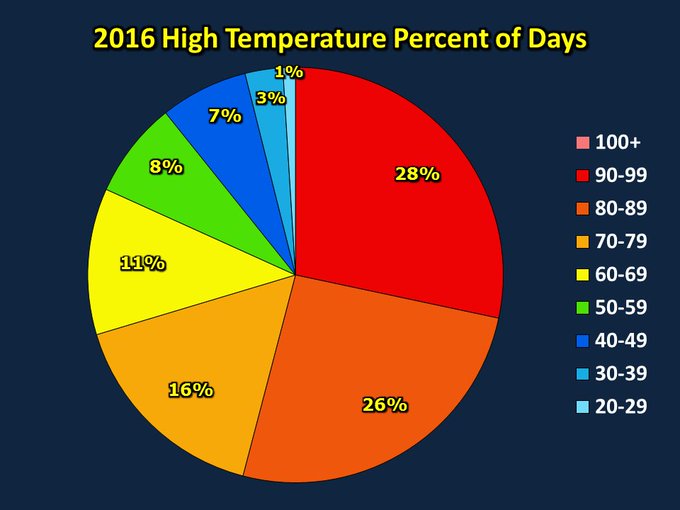
It's remarkable that we've had more high temperatures in the 90s this year than any other temperature range.

One other interesting tidbit is that Pittsburgh set a daily record of 80 degrees Wednesday, making it only the fourth time a high of 80 degrees was recorded in November.
MORE: America's 50 Hottest Winter Cities

Record Dry Streaks Leave Parts of the South Rainless Since September

Jon Erdman
Published: November 4,2016

Parts of the Deep South haven't seen measurable rain since September, setting new all-time record dry streaks and quickly worsening the Southeast's drought this fall.
Chief among these streaks is Alabama's most populous city.
No measurable rain (at least .01 inches) has been tallied at Birmingham's Shuttlesworth International Airport since Sept. 18, over a month and a half's time, a record-long dry streak for the city dating to 1930.
Birmingham, Alabama, Record Long Streaks Without Measurable Rain
As of Nov. 3, 2016 (Source: ACIS)
 StreakEnding Date
1.46 daysIn progress
2.43 daysOct. 4, 1955
3.36 daysOct. 25, 1987
Nine minutes of sprinkles Friday morning, and another bout of sprinkles on Oct. 16 has been the entirety of Birmingham's rainfall so far this fall.
They're not alone. Anniston, Alabama, Meridian, Mississippi, and Rome, Georgia, each have 38-day dry streaks through Thursday, tying a new record in Anniston and topping a record in Rome.
The Weather Channel meteorologist Kathryn Prociv noted even rainfall totals in the Desert Southwest since Oct. 1 were topping those in the "Desert Southeast."
We're calling it "The Desert Southeast" on @weatherchannel. Another telling visual for how dry the southeast has been since Oct 1.

While not record-setting, perhaps most impressive are the over-month-long dry streaks along the Gulf Coast in Mobile, Alabama, and Pensacola, Florida, each at 37 straight days through Nov. 3.
Estimated 30-day rainfall ending at 8 a.m. EDT on November 4, 2016. Dearth of rainfall in western Georgia, Alabama and the western Florida panhandle is denoted by tan shading.
(NOAA/NWS)
Mobile failed to record any precipitation in October for only the second month in records dating to 1871. The only other month this occurred was October 1874, during which their record dry streak of 42 straight days was set.
It has been an odd turn of events for this stretch of the Gulf Coast. As of mid-April, Mobile had tallied its record wettest year-to-date.

Drought 'Rapidly' Worsens

Going over a month without rain, coupled with record-smashing heat, quickly plunged a large part of the Southeast into a worsening drought, reaching exceptional levels in parts of Alabama, Tennessee and Georgia.
Reservoir levels have plunged, triggering major water restrictions. Friday, a stage 4 extreme drought emergency was declared in the city of Birmingham.
According to The Weather Channel meteorologist Mike Seidel, over 1,200 fires have burned in Alabama since Oct. 1.
Incredibly, Hurricanes Hermine and then Matthew both soaked parts of North Florida, eastern Georgia and the Carolinas, but both delivered little or no rain to Alabama, the western Florida Panhandle and the Tennessee Valley.
Strangely, the rain shut off after that for the rest of October in most of the hurricane-soaked areas.

Any Relief Ahead?

In the upcoming week, an upper-level system that had been soaking parts of the Desert Southwest and Texas should spread rain into parts of Oklahoma, Arkansas and Louisiana, parts of which have also slipped into drought in recent weeks.
(MAPS: 7-Day National Rain Forecasts)
However, it's not yet clear how much, if any, of that rain will make it to the drought areas of the Tennessee Valley and Deep South that desperately need it. A potential southward-plunging cold front late in the week or weekend may fail to squeeze out any precipitation as it moves in.
The long-range outlook for the rest of November from The Weather Company, an IBM Business, doesn't paint a rosy picture for drought relief either. Despite temperatures finally trending at least a bit off the recent record highs, it may be a while before a good soaking rain quenches the Southeast drought's thirst.
Jonathan Erdman is a senior meteorologist at weather.com and has been an incurable weather geek since a tornado narrowly missed his childhood home in Wisconsin at age 7.

Four Things To Know About Next Week's Weather

Linda Lam
Published: November 4,2016

Quiet and mild weather conditions have dominated the weather for much of the U.S. so far in November, but there are some changes ahead.
Much of the country can expect dry conditions to persist in the week ahead, but rain is expected in the southern Plains and Lower Mississippi Valley. The trend of above-average temperatures will also continue, but it will not be quite as warm as this past week.
Below we take a closer look at the four things you need to know about the weather as we move toward mid-November.

1. Wet Weather in Southern Plains, Lower Mississippi Valley

Rain is expected for much of next week in the southern Plains due to an upper-level area of low pressure. Surface high pressure centered over the East will allow a southerly flow to develop over the southern Plains, bringing moisture into the region.

Rainfall Forecast
Locally heavy rain is a possibility, especially Sunday and Monday in central and eastern Texas, as well as into Oklahoma and far-western Louisiana. Thunderstorms are also likely, but widespread severe thunderstorms are not anticipated.
Drought conditions have been spreading across the Lower Mississippi Valley and into eastern Texas and eastern Oklahoma since the end of September, so this rainfall will likely be beneficial for those areas.
(MAPS: Weekly Planner)
There is some uncertainty as the week progresses as to the timing and how far east the chances of rain will reach. It currently appears that the chance of showers could stretch into the Tennessee Valley late in the week.
(FORECAST: Houston | Dallas | Oklahoma City | New Orleans)

2. Not Much Drought Relief in Southeast, Northeast

Unfortunately, there does not seem to be much rain in the East over the coming week as high pressure will continue to influence conditions across the region.

Forecast For The Week Ahead
A couple of upper-level disturbances may move through the Northeast midweek, bringing a few rain and snow showers mainly to the interior and higher elevations. However, widespread precipitation appears unlikely, which is not good news for the drought in the region.
(MORE: South May Not See Much Relief from Drought This Winter)
The Southeast will also see mostly dry conditions, at least through early week. Mid-to-late week, the chance of rain increases slightly as the system that will bring rain to the southern Plains may push eastward enough to bring a few showers to portions of the Southeast.
However, given differences in the forecast models and the fact that it is several days away there is a good deal of uncertainty regarding how much, if any, rainfall makes it into the region. The drought in the region continues to worsen so any change in the dry pattern will be very welcome. Make sure to check back with weather.com for forecast updates.
(FORECAST: Boston | Philadelphia | Atlanta | Birmingham)

3. The Warmer Than Average Trend Continues

Temperatures will continue to be warmer than average next week from the northern Plains and intermountain West into the Midwest and Southeast. The Northeast, southern Plains and the West Coast will experience temperatures near to slightly above average.

Forecast Highs
These above-average temperatures are due to an upper-level ridge of high pressure over the central U.S.
There may be a few daily record highs through the week but we are not expecting widespread records like this past week, as it will not be as warm.
(MORE: Record Heat to End October and Begin November)
Highs will climb into the 60s for much of the Plains and Midwest, with 70s toward the Ohio Valley and 50s in the Upper Midwest. Farther east, the mid-Atlantic will enjoy highs in the 60s with 70s in the South.
Low temperatures will also be warmer than you would normally expect heading into mid-November, especially in parts of the Rockies, northern Plains and Midwest. Temperatures will only drop into the 40s for much of the Midwest and into the Northeast and portions of the Southeast. If you are looking for lows below the freezing mark you will need to go toward northern New England and the higher elevations of the inter-mountain West.
(FORECAST: Denver | Minneapolis | Chicago | Nashville)

4. Unsettled in Pacific Northwest

A moist southwesterly flow will be in place across the Pacific Northwest next week. This will allow wet conditions to impact the region at times during the week.

Tuesday's Forecast
Precipitation is expected to be generally light across most of the region and will mainly be confined to the west coast of Washington and northwestern Oregon. The best chance for moderate to heavy rainfall will be on the Olympic Peninsula and in far northern Washington.
(MORE: Seattle's Rainy Reputation Is Well-Deserved)
However, there is a chance that some of the rain and showers may push farther east midweek. Another system may bring a more widespread chance of rain late in the week.
(FORECAST: Seattle | Portland, Oregon | Crescent City, California)
MORE: Autumn Animals

Election Day Forecast: Could Weather Have an Impact?

Brian Donegan
Published: November 4,2016

Election Day is just a couple days away, and you may be wondering what conditions will be like as you head out to the polls Tuesday. Could the weather possibly turn the Senate race, or even the presidency?
While there is still some minor forecast uncertainty this far out in time, we're not expecting a major storm anywhere in the U.S.
(MAPS: Weekly Planner)
However, some inclement weather is possible in a few spots. Let's take a region-by-region tour of Tuesday's forecast.

Election Day Forecast

Northeast

Fortunately, a stronger area of low pressure should remain sufficiently offshore, southeast of Atlantic Canada, to have zero impact on the weather near the Northeast seaboard.
There is a cold front that will push toward the eastern Great Lakes, with a threat of rain showers associated with that. Typical for a forecast this far out, the timing of that feature remains in question, but the best chance of showers appears to be after the polls close Tuesday evening from western New York to northern New England.
Elsewhere, the weather should be dry.
Highs will be above average for the second week of November, generally in the 50s in New York state and New England, and 60s from New York City southward into the mid-Atlantic states.
(FORECAST: Boston | New York | Pittsburgh | Washington D.C.)

South

The greatest chance for wet weather will be in the south-central states, including parts of Texas, Louisiana, Mississippi, Arkansas and Oklahoma. DallasHouston and New Orleans are among the cities where rain is possible.  This threat of rain appears to be growing both in extent and in forecast confidence.
Temperatures will be up to 15 degrees above average across the region, translating to highs mainly in the 70s to perhaps even near 80 degrees in the Deep South.
(FORECAST: Atlanta | Miami | Memphis, Tennessee | Dallas)

Midwest

A cold front will be sliding across the Great Lakes on Election Day, bringing a low chance for a few showers out ahead of it.
If the front slows down, the showers would set up farther to the west. If it speeds up, they'd set up farther east. Stay tuned for updates over the next several days.
Most midwesterners will stay dry as they head to the polls.
No cold weather is expected with high temperatures 10 to 20 degrees above average across the entire region, this corresponds to highs in the 50s and 60s for most locations.
(FORECAST: Detroit | Chicago | Minneapolis | St. Louis)

West

The only hiccup in the forecast may be a weak Pacific system bringing rain to western Washington, Oregon and northwestern California.
The rest of the West is currently expected to be dry and pleasant with sunshine and above-average temperatures (away from the immediate coast).
Highs will range from the 50s and 60s across the Northwest, to the 70s and 80s in Southern California and the Desert Southwest.
(FORECAST: Los Angeles | Denver | Seattle | Salt Lake City)
MORE: Election Day Photos

Weather Underground National Forecast for Friday,November 4,2016

By: nationalsummary , 10:00PM,GMT on November 3,2016


Weather Underground Forecast for Friday,November 4,2016

A stormy weather pattern will persist across the Four Corners on Friday, while a strong cold frontal boundary approaches the Northwest.

A cold frontal boundary will extend southwestward across the western Atlantic, the Gulf Coast, the southern Plains and the lower Intermountain West. A plume of moisture will interact with he tail end of this frontal boundary, which will lead to moderate to heavy rain and thunderstorms across the Four Corners. Locally heavy rain will bring threats of flash flooding to New Mexico, especially along sloped terrain. Showers and thunderstorms will also develop along and near this frontal boundary across the southern Plains, the Gulf Coast and the Southeast. Additionally, a low pressure system associated with the frontal boundary will generate a light mixture of rain and snow in northern Maine. Cold and dry air will settle in across the remainder of the Northeast on Friday.

Meanwhile, a strong Pacific cold frontal boundary will approach the Northwest. Moderate to heavy rain and high elevation snow will develop ahead of this frontal boundary over western Washington and western Oregon.

A ridge of high pressure should keep weather conditions dry in California, the Great Basin and the upper Intermountain West. The same high pressure system will expand over the Plains, drying conditions out from the northern Plains to the Great Lakes.

This Date in Weather History for November 5,2016 from weatherforyou.com

Weather History
For Saturday,November 5,2016


1894 - The famous Election Day snowstorm occurred in Connecticut. As much as a foot of wet snow fell, and the snow and high winds caused great damage to wires and trees. Winds gusted to 60 mph at Block Island RI. (David Ludlum)
1961 - Strong Santa Ana winds fanned the flames of the Bel Air and Brentwood fires in southern California destroying many homes. At 10 PM the Los Angeles Civic Center reported a temperature of 74 degrees along with a dew point of 5 degrees. On the 6th, Burbank reported a relative humidity of three percent. (The Weather Channel)
1977 - A slow moving storm produced five to nine inch rains across northern Georgia causing the Toccoa Dam to burst. As the earthen dam collapsed the waters rushed through the Toccoa Falls Bible College killing three persons in the dorms. Thirty-eight persons perished at a trailer park along the stream. (David Ludlum)
1987 - Low pressure off the California coast produced stormy weather in the southwestern U.S. Flash flooding stranded 8000 persons in the Death Valley National Park of southern California. Thunder- storms over southern Nevada produced dime size hail and wind gusts to 68 mph around Las Vegas. Unseasonably mild weather in the northeastern U.S. was replaced with snow and gale force winds. (The National Weather Summary) (Storm Data)
1988 - A powerful low pressure system produced high winds from the Great Plains to New England, and produced heavy snow in northern Wisconsin and Upper Michigan. Winds gusted to 64 mph at Knoxville TN, and reached 80 mph at Pleasant Valley VT. (Storm Data) (The National Weather Summary)
1989 - Temperatures warmed into the 80s across much of Texas. Highs of 86 degrees at Abilene, Fort Worth and San Angelo were records for the date. (The National Weather Summary)
2002 - Severe thunderstorms moved across southeastern Alabama and the Florida panhandle, producing wind damage and several tornadoes. A tornado struck the Alabama town of Abbeville killing 2 people and injuring 25 (Associated Press).

This Date in Weather History for November 4,2016 from weatherforyou.com

Weather History
For Friday,November 4,2016


1927 - A great Vermont flood occurred. Tropical rains deluged the Green Mountain area of Vermont causing the worst flood in the history of the state. Torrential rains, up to 15 inches in the higher elevations, sent streams on a rampage devastating the Winooski Valley. Flooding claimed 200 lives and caused 40 million dollars damage. The town of Vernon reported 84 deaths. Flooding left up to eight to ten feet of water in downtown Montpelier VT. (2nd-4th) (David Ludlum) (The Weather Channel)
1985 - A super wet Gulf storm dumped upwards of fifteen inches of rain in the mountains of Virginia and West Virginia causing devastating damage and claiming forty lives. (Sandra and TI Richard Sanders - 1987)
1987 - Thirty-two cities in the eastern and south central U.S. reported record high temperatures for the date. Highs of 74 degrees at Portland ME and 86 degrees at Fort Smith AR equalled November records. It was the fourth day of record warmth for Beckley WV, Memphis TN and Paducah KY. A cold front ushered much colder air into the north central U.S. Gale force winds lashed all five Great Lakes. (The National Weather Summary)
1988 - Thunderstorms developing ahead of a fast moving cold front produced severe weather over the Tennessee Valley and the Central Gulf Coast States during the afternoon and evening hours, and into the next morning. Thunderstorms spawned nineteen tornadoes, including eleven in Mississippi. The last of the nineteen tornadoes killed a woman in her mobile home in Lee FL. A tornado in Culbert AL injured sixteen people, and caused two million dollars damage. Thunderstorms also produced baseball size hail in Alabama. Unseasonably hot air prevailed south of the cold front. McAllen TX was the hot spot in the nation with a high of 102 degrees. (The National Weather Summary) (Storm Data)
1989 - Snow and high winds plagued parts of Colorado and Wyoming. Winds gusted to 71 mph near Wheatland WY, and reached 80 mph west of Fort Collins CO. Up to five inches of snow blanketed Yellowstone Park WY closing many roads. Snow also blanketed northern Minnesota, with seven inches reported at Baudette. (The National Weather Summary) (Storm Data)

This Date in Weaher History for November 3,2016 from weatherforyou.com

Weather History
For Thursday,November 3,2016


1890 - The temperature at Los Angeles, CA, reached 96 degrees, a November record for 76 years. (David Ludlum)
1927 - Somerset VT was deluged with 8.77 inches of rain to establish a 24 hour record for the state. (3rd-4th) (The Weather Channel)
1961 - A rare November thunderstorm produced snow at Casper, WY. (3rd-4th) (The Weather Channel)
1987 - Twenty-one cities, mostly in the Ohio Valley, reported record high temperatures for the date. The afternoon high of 80 degrees at Columbus OH was their warmest reading of record for so late in the season. Showers and thundershowers associated with a tropical depression south of Florida produced 4.28 inches of rain at Clewiston in 24 hours. (The National Weather Summary) (Storm Data)
1988 - A sharp cold front brought about an abrupt end to Indian Summer in the north central U.S. Up to a foot of snow blanketed Yellowstone Park WY, and winds in the mountains near the Washoe Valley of southeastern Wyoming gusted to 78 mph. Unseasonably warm weather continued in the south central U.S. Del Rio TX tied Laredo TX and McAllen TX for honors as the hot spot in the nation with a record warm afternoon high of 91 degrees. (Storm Data) (The National Weather Summary)
1989 - Cold weather prevailed in the central U.S. Six cities in Texas, Minnesota, and Michigan, reported record low temperatures for the date. The low of 7 above zero at Marquette MI was their coldest reading of record for so early in the season. (The National Weather Summary)

Wednesday, November 2, 2016

Weather Underground National Forecast for Wednesday,November 2,2016

By: nationalsummary , 10:00PM,GMT on November 1,2016


Weather Underground Forecast for Wednesday,November 2,2016

Active weather will affect states stretching from the southern Plains to the Midwest on Wednesday, while a wet weather pattern persists along the northwestern corner of the country.

A cold frontal boundary will extend southwestward from southeast Canada to the southern high Plains. This frontal boundary will transition slowly eastward, generating showers and thunderstorms from the Midwest to the lower Intermountain West. A wave of low pressure will form along this frontal boundary, which could result in locally heavy rain and strong thunderstorms over the middle Mississippi Valley. Scattered showers will also be possible in parts of the northern Mid-Atlantic and New England on Wednesday.

Meanwhile, a ridge of high pressure will build over the southeast quadrant of the country. This system will influence an onshore flow along the western Gulf Coast and the eastern edge of the Florida Peninsula. This onshore flow will result in scattered showers and isolated storms in eastern Florida and along parts of the Gulf Coast.

Out west, a cold frontal boundary will approach the West Coast. Moderate to heavy rain will develop ahead of this frontal boundary over western Washington. By Wednesday afternoon and evening, showers will develop in western Oregon and the northwestern corner of California. High elevation snow is also in the forecast for the northern Cascades. Most of the Great Basin and the upper Intermountain West will stay clear of precipitation on Wednesday.

This Date in Weather History for November 2,2016 from weatherforyou.com

Weather History
For Wednesday,November 2,2016


1946 - A heavy wet snow began to cover the Southern Rockies. Up to three feet of snow blanketed the mountains of New Mexico, and a 31 inch snow at Denver CO caused roofs to collapse. (David Ludlum)
1961 - The temperature at Atlanta, GA, reached 84 degrees to establish a record for November. (The Weather Channel)
1966 - A storm brought 18 inches of snow to Celia KY in 24 hours. It tied the state 24 hour snowfall record first established at Bowling Green. (The Weather Channel)
1987 - A dozen cities, mostly in the Ohio Valley, reported record high temperatures for the date. Record highs included 83 degrees at Paducah KY and 84 degrees at Memphis TN. Temperatures reached 70 degrees as far north as southern Lower Michigan. Showers and thundershowers over southern Florida, associated with a tropical depression, produced 4.77 inches of rain at Tavernier, located in the Upper Florida Keys. (The National Weather Summary) (Storm Data)
1988 - A very intense low pressure system brought heavy rain, snow, and high winds, to parts of the northeastern U.S. Portland ME established a record for November with 4.52 inches of rain in 24 hours, and winds along the coast of Maine gusted to 74 mph at Southwest Harbor. Heavy snow blanketed parts of northern Vermont and upstate New York, with 15 inches reported at Spruce Hill NY. (The National Weather Summary) (Storm Data)
1989 - Squalls in the Upper Great Lakes Region the first three days of the month buried Ironwood MI under 46 inches of snow, and produced 40 inches at Hurley WI. Arctic cold invaded the Southern Plains Region. Midland TX reported a record low of 22 degrees. (The National Weather Summary) (Storm Data)

Tuesday, November 1, 2016

New York City metro-area for November 1-30,2016 from accuweather.com

Here's the 30-day weather forecast for the New York City metro-area for the period of all of November (November 1-30),2016 from accuweather.com


Tonight,November 1-2: Not as cold with partly to mostly cloudy skies and a low temperature holding in the upper 40's to lower 50's,overnight.As of 2AM,EDT,November 2,it's a balmy 52 degrees and partly cloudy,with 80% humidity,in White Plains,NY,and it's a balmy 54 degrees and cloudy,with 76% humidity,in New York City.

Tomorrow,November 2: Turning much warmer than recent days,as it turns unseasonably warm and balmy for mid-autumn and the beginning of November,with a mix of sunshine and some clouds and a near record high temperature in the upper 60's to lower 70's.

Tomorrow night,November 2-3: Remaining unseasonably mild to warm and balmy,with patchy clouds and a low temperature dropping to 55-60 degrees,which is where NORMAL MID-DAY HIGH TEMPERATURES ARE AT for this time of year,overnight.

Thursday,November 3: Turning mostly cloudy,rainy,stormy,unseasonably very warm and humid for mid-autumn and the beginning of November,with a chance for a couple of afternoon showers and a chance for a thunderstorm,which could be strong to severe,and a record,or near record high temperature in the lower and middle 70's.Becoming partly cloudy and not as warm,with a scattered evening shower or thunderstorm possible and a low temperature dropping to 45-50 degrees,overnight.

Friday,November 4: Turning mostly sunny,windy,and markedly colder than recent days,with a high temperature only in the lower and middle 50's.Becoming clear and markedly colder than recent nights,with a low temperature dropping to 35-40 degrees,overnight.

Saturday,November 5: Becoming partly sunny,breezy,and seasonably cool to mild for very early November,with a high temperature of 55-60 degrees.Becoming partly cloudy and not as cold,with a low temperature dropping to 40-45 degrees,overnight.

Sunday,November 6: Remaining partly sunny,breezy,and seasonably cool for early November,with a high temperature of 55-60 degrees,once again.Becoming mainly clear and not as mild,with a low temperature dropping to 35-40 degrees,overnight.

Monday,November 7: Remaining partly sunny,but turning cooler than recent days,with a high temperature of 50-55 degrees.Becoming mainly clear,but remaining seasonably cold for mid-autumn, with a low temperature dropping to 35-40 degrees,once again,overnight.

Tuesday,November 8: Election Day 2016 will be not as chilly,with plenty of sunshine,and a high temperature of 55-60 degrees.Becoming partly cloudy and not as cold as recent nights,with a low temperature dropping to 40-45 degrees,overnight.

Wednesday,November 9: Turning cloudy and rainy,but remaining seasonably cool for early November and mid-autumn,with occasional rain and a high temperature of 55-60 degrees,once again.Remaining cloudy,rainy,raw,dank,dreary,and seasonably cold for early November,with periods of rain and a low temperature dropping to 35-40 degrees,the blustery,biting,northwesterly winds making it feel even colder,like it's only in the upper 20's to lower 30's,at times,overnight.

Thursday,November 10: Remaining seasonably cool for mid-to-late autumn,with morning cloudiness followed by afternoon sunshine and a high temperature,for the third straight day,of 55-60 degrees.Becoming mainly clear,but remaining seasonably cold for mid-autumn,with a low temperature dropping to 35-40 degrees,once again,overnight.

Friday,November 11: Veteran's Day 2016 will be remaining seasonably cool for early November, with considerable cloudiness and a high temperature in the middle and upper 50's.Remaining cloudy,but not as cold as recent nights,with rain at times and a low temperature dropping to 40-45 degrees,the blustery,biting,southwesterly winds,which could gust up to 25-mph,at times,making it feel even colder,like it's only in the middle 30's,at times,overnight.

Saturday,November 12: Remaining cloudy,rainy,raw,dank and dreary,with occasional rain and a high temperature of 55-60 degrees.Remaining rather mild for early-to-mid November,with patchy clouds and a low temperature dropping to 40-45 degrees,once again,overnight.

Sunday,November 13: Turning colder than recent days,with times of clouds and sun and a chance for a couple of rain showers,and a high temperature only in the upper 40's to lower 50's.Becoming clear and colder than recent nights,with a low temperature dropping to the lower and middle 30's, overnight,making this one of the coldest nights of the 2016 autumn season,so far.

Monday,November 14: Becoming mostly sunny and chilly,with a chance for a rain shower and a high temperature of just 45-50 degrees.Becoming mainly clear,but remaining seasonably cold for mid-November and late autumn,with a low temperature dropping to the middle 30's,overnight.

Tuesday,November 15: Becoming cloudy,but remaining seasonably chilly for mid-November and late autumn,with a high temperature in the upper 40's to lower 50's.Remaining cloudy,raw and cold,with periods of rain changing to freezing rain/ice or sleet late and a low temperature dropping to 30-35 degrees,overnight.

Wednesday,November 16: Remaining cloudy,rainy,raw,and seasonably chilly for mid-November, with a chance for a rain shower and a high temperature in the upper 40's to lower 50's,once again.Remaining cloudy and seasonably cold for late autumn,with a low temperature dropping to the middle 30's,overnight.

Thursday,November 17: Becoming partly sunny,but remaining seasonably chilly for mid-to-late November,with a high temperature of around 50 degrees.Becoming mainly clear,but remaining cold with a low temperature dropping to 30-35 degrees,the blustery,biting,northwesterly winds, which could gust up to 20-mph,at times,making it feel like it's only 25-30 degrees,at times,overnight.

Friday,November 18: Remaining seasonably chilly for mid-to-late November,with increasing cloudiness and a high temperature of 50-55 degrees.Turning cloudy,rainy,and not as cold as recent nights,with a chance for an evening rain shower followed by some late-night rain possible and a low temperature dropping to 35-40 degrees,overnight.

Saturday,November 19: Remaining seasonably chilly with morning cloudiness followed by afternoon sunshine and a high temperature in the upper 40's to lower 50's.Remaining mostly cloudy and seasonably cold for late autumn,with a low temperature dropping to the middle 30's,the blustery, biting,southwesterly winds,which could gust up to 20-mph,at times,making it feel much colder,like it's only in the lower and middle 20's,at times,overnight.

Sunday,November 20: Remaining seasonably chilly with partial sunshine and a high temperature of 45-50 degrees.Remaining clear and seasonably cold with a low temperature dropping to the middle 30's,once again,the blustery,biting,northwesterly winds,which could gust past 30-mph,at times,making it feel much colder,like it's only in the middle 20's,at times,overnight.

Monday,November 21: Remaining seasonably chilly,with abundant sunshine,and a high temperature in the upper 40's to lower 50's.Remaining seasonably cold for late November,with increasing cloudiness and a low temperature dropping to 30-35 degrees,overnight.

Tuesday,November 22: Turning cloudy,rainy,raw,dank,dreary,and chilly,with considerable cloudiness and a chance for a little rain and a high temperature in the middle and upper 40's,the blustery,biting, southerly winds,which could gust up to 30-mph,at times,making it feel even colder,like it's only 35-40 degrees,at times.Becoming clear to partly cloudy,but remaining seasonably cold for very late November and late autumn,with a low temperature dropping to the lower and middle 30's,overnight.

Wednesday,November 23: Becoming partly sunny and not as cold,with a high temperature in the upper 40's to lower 50's.Becoming clear and seasonably cold for very late November,with a low temperature dropping to the middle 30's,the blustery,biting,northwesterly winds,which could gust past 25-mph,at times,making it feel even colder,like it's only 25-30 degrees,at times,overnight.

Thursday,November 24: Thanksgiving Day 2016 will be turning sunny and milder than recent days,with a high temperature of 50-55 degrees.Remaining clear and seasonably cold for very late November,with a low temperature dropping to 30-35 degrees,overnight.

Friday,November 25: Black Friday 2016 will be turning colder than recent days,with increasing cloudiness and a high temperature only in the lower and middle 40's.Becoming cloudy and not as cold,with a low temperature dropping to 35-40 degrees,overnight.

Saturday,November 26: Turning cloudy,rainy,and warmer than recent days,with a chance for a couple of morning rain showers followed by a little afternoon rain possible and a high temperature in the middle 50's.Becoming mainly clear and milder/warmer than recent nights,with a low temperature dropping to the upper 30's to lower 40's,overnight.

Sunday,November 27: Becoming sunny and not as mild,with a high temperature in the upper 40's to lower 50's.Becoming mostly cloudy and not as mild,with a low temperature dropping to 35-40 degrees,overnight.

Monday,November 28: Remaining rather mild for the end of November,with partial sunshine and a high temperature of 50-55 degrees.Becoming cloudy and mild with a low temperature dropping to around 40 degrees,overnight.

Tuesday,November 29: Turning cloudy and rainy,but remaining unseasonably mild for the end of November and one of the warmest autumns on record,with considerable cloudiness with morning rain followed by some leftover afternoon showers and a high temperature in the middle 50's.Becoming mainly clear,but remaining rather mild for the end of November,with a low temperature dropping to the upper 30's to lower 40's,overnight.

Wednesday,November 30: November of 2016;one of the warmest Novembers on record,ends remaining unseasonably mild with ample sunshine and a high temperature in the middle and upper 50's.Remaining clear and mild with a low temperature dropping to around 40 degrees,overnight.

Brief warmup to develop in northeastern US at midweek

By Brett Rathbun, AccuWeather.com Meteorologist
November 1,2016; 11:57PM,EDT
 
 
Another warmup will take shape over the northeastern United States at midweek.
"Temperatures could challenge record highs in some areas, following another bout of frost and early-morning chill that started the week," according to AccuWeather Senior Meteorologist Alex Sosnowski.
During Monday and Tuesday, temperatures from Washington, D.C., to Boston hovered between 15 and 25 degrees Fahrenheit lower than over the weekend.
RELATED:
US winter forecast: Frequent snow to blast Northeast
5 weather threats to be wary of during the fall
Check AccuWeather MinuteCast® for your location

The warmer air began to push into the Ohio Valley on Tuesday and will reach the rest of the mid-Atlantic and parts of New England on Wednesday.
Highs at the peak of the warmth will be similar to those from this past weekend.

Temperatures will again reach into the 70s across much of the mid-Atlantic and into the 60s across southern New York and New England. Temperatures will approach 80 on Thursday around Washington, D.C., which happens to be the record high set in 1974.
Highs will be in the 50s across northern New England.
However, the warm spell will be brief.
"An approaching storm will lead to the development of showers and thunderstorms during Thursday afternoon from northern Virginia into southern New England, some of which could contain damaging winds," according to AccuWeather Meteorologist Matt Rinde.

Those along the Interstate-95 corridor from Boston to New York City and Washington, D.C., will want to keep an eye to the sky for rapidly changing weather conditions.
Additional waves of colder air will make appearances to the Northeast for much of November and into December. Warmups in-between will likely become increasingly abbreviated.


Neven Prvinic ·
Cleveland, OH officially hit 80F today, November 1st. 82F is the all time November record.
Like · Reply · 1 hr
Rocco Salvemini ·
This should be the final time NYC hits 70 till at least nxt spring
Debbie Brunell
all looks to be going right on track for the cold weather to finally settle in for good, i have been waiting for november to arrive, and love the words " warmups will become increasingly abbreviated "
Like · Reply · 2 · 13 hrs
Deanne L. McKimmey ·
SICK OF ROLLER COASTER WEATHER!!! CAN'T IT JUST STAY SEASONAL/COLD????????


2016 New York City Marathon: Ideal weather conditions to benefit runners

November 1,2016; 10:50PM,EDT
 
 
More than 50,000 runners will trek through the five boroughs of New York City on Sunday, Nov. 6, for the 46th annual New York City Marathon.
A chilly but dry morning is in store for the runners. However, light winds would ease the difficulty of the grueling 26.2-mile course.
The first wave to take the starting line will be the professional women racers at 9:20 a.m. EST. The last wave is set to start at 11 a.m. EST.

"Runners can leave rain gear behind as dry and partly sunny conditions will dominate on Sunday, but a chilly breeze from the northwest may force onlookers to out the jackets," AccuWeather Meteorologist Renee Duff said.
Winds will most likely be out of the northwest during the event.
How quickly a storm system departs southeastern Canada will ultimately determine how much wind impacts the runners and how high temperatures will rise by the end of the race.
"Should the system depart quickly by Sunday, race day will feature light winds and milder conditions," Duff said.
RELATED:
Detailed New York City Forecast
Brief warmup to develop in northeastern US at midweek
5 easily spread illnesses that peak in fall, winter

Should the storm linger and strengthen over southeastern Canada, blustery conditions could linger and be a challenge for runners around New York City on Sunday.
Even though temperatures to start the race are expected to be in the middle 40s F, temperatures will slowly rise into the lower 50s by the time the event concludes at 2 p.m. EST.
The forecast for this year's event looks promising for runners, according to Bart Yasso, chief running officer for Runner's World.
The light wind is key, because the start of the marathon is at the Verrazano-Narrows Bridge in Staten Island and it can be "really breezy up there," Yasso, who has run the marathon three times, said.
Runners cross the Verrazano-Narrows Bridge at the start of the New York City Marathon, Sunday, Nov. 1, 2015, in New York. (AP Photo/Jason DeCrow)
"Very little wind will be a very big advantage to the runners," Yasso said.
Temperatures in the 50s are favorable, Yasso said. Highs in the upper 60s or lower 70s would be too warm, and temperatures in the high 30s or low 40s would be too cold for a lot of runners, he continued.
Temperatures for the majority of the race will center around 50 and seem ideal to the majority of runners.
This story was written by AccuWeather Meterologist Kyle Elliott