Saturday, April 30, 2016

Volatile Sakurajima volcano is a lightning laboratory

By Dr. Jeffrey Johnson
April 30,2016; 6:37AM,EDT
 
A high-speed image of volcano lightning at Sakurajima Volcano. (Photo/Corrado Cimarelli)
Japan is a country of volcanoes, and Sakurajima is one of its most infamous. Its notoriety stems from its poor behavior in 1914, when powerful explosions and pyroclastic flows forced the evacuation of the small volcanic island. Shortly after the explosions stopped, extensive lava eruptions began. The amount of lava that erupted was enough to span Kagoshima Bay, connecting the volcano to Kyushu's mainland. For much of the next forty years, the volcano was relatively quiet.
But Sakurajima has been exploding intermittently since 1955. And although it no longer is an island, it is still nearly surrounded by water, and its 7,000 residents are exposed to volcanic hazards including ash fall, lahars, and the potential for lava bombs. Today, schoolchildren commute wearing hard hats just in case rocks start to rain down from the sky. Because ashfall often grays the landscape, everyone wears masks to avoid breathing in the tiny particles of volcanic glass. While downwind areas on the island are more vulnerable to the ashfall, no corner of the island remains completely unaffected, since any location is less than 4 miles from the exploding crater.
Although explosions are a worrisome inconvenience to the local population, the phenomenon draws volcano scientists to the region like moths to a flame: Sakurajima's reliable, frequent and powerful explosions provide researchers with an unparalleled laboratory for studying eruptions that are categorized as quintessentially "vulcanian."
On a typical day, a few vulcanian blasts can be expected to erupt out of the Showa Crater like canon shots. Ten seconds later, a concussion sound wave - often exceeding 100 pascals in pressure, akin to the sound pressure levels on an aircraft carrier deck - reaches the Kurokami Observatory 2 miles away. Most of this sound energy is subsonic, but if it were audible, it would be deafening: the equivalent of 140 decibels. To put it another way, it would exert a force of approximately 100 lbs. on a (well-sealed) window.
 

PHOTOS: Late-April snowstorm extends Colorado ski season into early May

By Renee Duff, AccuWeather.com Meteorologist
April 30,2016; 11:58AM,EDT
 
A skier enjoys fresh powder on opening day at Arapahoe Basin, Thursday, Oct. 29, 2015, in Dillon, Colorado. (AP Photo/Jack Dempsey)
A late-April snowstorm dumped over a foot of heavy, wet snow across parts of Colorado on Thursday into Friday, boosting snowpack for an extended ski season at local resorts.
The highest snowfall totals focused on the southern and central portions of the state. Over a foot of snow buried Matheson, Colorado, about 50 miles northwest of Colorado Springs.
Amounts between 6 to 12 inches of snow were widespread across the southern Rockies.
Heavy snow persisted for over 12 consecutive hours in some areas.
The fresh powder allowed Wolf Creek Ski Area in southwestern Colorado to reopen this weekend. The resort had previously closed on April 17 with the option to reopen should Mother Nature cooperate.
RELATED:
AccuWeather winter weather center
Goodbye Joaquin, Patricia and Erika: World Meteorological Organization retires 3 names from 2015 hurricane season
Weekly wrap-up: Severe storms rattle central US; UN seeks billions to offset El Nino's devastating blow to 60 million worldwide

Ski resorts in Aspen, Winter Park and Loveland, Colorado, had already announced extended openings into early May prior to the snowstorm. Less than half a foot of snow fell in these locations.
 A few resorts plan to stay open into Mother's Day weekend.
Snow is still looking pretty fresh and ready for some tracks this weekend. @GoPro 🐶

Heavy snow coats outdoor furniture near Black Forest, Colorado. (Twitter photo/@SarahASimon)
Livestock cross an open field as heavy snow falls in Elbert County, Colorado. (Twitter photo/@ElbertCountyOEM)
The heavy nature of the snow caused some tree damage in parts of Colorado.
A tree sags under the weight of heavy snow in Texas Creek, Colorado. (Twitter photo/@NWSPueblo)
Accumulating snow fell as far east as Goodland, Kansas, on Friday. (Twitter photo/@dlfloyd3)
Tulips topple under the weight of snow in Englewood, Colorado. (AP Photo/David Zalubowski)
Dirt roads became muddy and snow-covered in El Paso County, Colorado. (Twitter photo/@NWSPueblo)


Severe storms to raise flood risk in Deep South Saturday

By , AccuWeather.com Senior Meteorologist
April 30,2016; 11:53AM,EDT
 
 
The risk of severe thunderstorms and flash flooding will shift to the Deep South for the first half of the weekend.
A line of intense thunderstorms will continue to march from Louisiana to Mississippi into Saturday evening. The storms will bring the potential for damaging wind gusts, large hail, frequent lightning strikes and isolated tornadoes.
One severe thunderstorm within this line earlier on Saturday produced a 60-mph wind gust at Austin-Bergstrom International Airport, Texas. Air operations at the airport reported that two 737's sustained damage at their terminal gates after being shifted by the winds.

The slow-moving nature of the storm system, combined with the repeating nature of the thunderstorms will also bring an elevated risk of flash flooding.
Locally, 5 inches of rain will pour down. Of that rainfall, a couple of inches could fall in as many hours on some communities.
RELATED:
5 years later: Tuscaloosa, Birmingham reflect on deadly tornado that turned communities upside down
Goodbye Joaquin, Patricia and Erika: World Meteorological Organization retires 3 names from 2015 hurricane season
Nonprofit organization rolls out plan for disaster-resistant homes in Tornado Alley

Cities at risk for the severe and flooding thunderstorms include Baton Rouge, Louisiana, and Jackson, Mississippi.
An elderly woman and her four grandchildren were killed early Saturday morning after a creek overflowed its banks in Palestine, Texas, following torrential rainfall, according to the Associated Press. Between six to 10 homes in the family's cul-de-sac were severely damaged by the flood waters.
More flooding along FM 2625. Turn Around, Don't Drown!

Intense thunderstorms will not just be confined to the Deep South. A few potent thunderstorms with hail, strong winds and downpours will erupt from southern Missouri to central Kentucky and Tennessee on Saturday afternoon and early evening. This includes in St. Louis and Nashville.
Residents are reminded to seek shelter as soon as thunder is heard even in the absence of severe thunderstorm warnings. The danger of being struck by lightning is then present.

There have been five lightning fatalities in the United States so far this year, according to National Oceanic and Atmospheric Administration Lightning Safety Specialist John Jensenius.
"The five fatalities this year are the most this year in the season since 2001 (when there were seven fatalities by April 27)," Jensenius said.
By Sunday, the threat of locally flooding downpours and severe thunderstorms will extend as far north as the Ohio Valley and as far south as the central Gulf Coast.
Content contributed by AccuWeather Senior Meteorologist Kristina Pydynowski.

May to start on warm, muggy note in southeastern US

By , Senior Meteorologist
April 30,2016; 11:52AM,EDT
 
Residents of the southeastern United States may feel like the calendar has flipped ahead to Memorial Day weekend with warm and muggy weather in place for the start of May.
After the passage of a cold front brought cooling to North Carolina to end April, warm and humid air will surge back across all of the Southeast to kick off May.
"A predominantly southerly flow [of air] will set up across the Southeast this weekend and head into Monday," AccuWeather Meteorologist Maggie Samuhel said.
"Moisture will be picked up from the warming Gulf of Mexico waters and carried into the region, bringing high dew points."

Highs in the 80s will dominate the Southeast from Florida to North Carolina Sunday into Monday. Some communities, the most numerous of which will be in central Florida, will even crack the 99-degree-Fahrenheit mark.
Highs in early May typically range from the middle 80s in central Florida to middle 70s in North Carolina.
A wind blowing in off the ocean will keep the beaches cooler than neighboring inland locations.
While actual temperatures may come up short, AccuWeather RealFeel® Temperatures in many communities will approach or top 90 during the first day or two of May due to the higher humidity. RealFeels will even rise into the upper 90s from southern South Carolina to the interior of Florida.
This includes in Jacksonville and Tallahassee, Florida; Augusta and Savannah, Georgia; Columbia, South Carolina; and Charlotte and Raleigh, North Carolina.
RELATED:
Southeast US interactive radar
Forecast temperature maps
Goodbye Joaquin, Patricia and Erika: World Meteorological Organization retires 3 names from 2015 hurricane season

While such steamy air is fairly common in summer, it may still put a strain on residents who have not yet become accustomed to it following the cooler winter and early spring months.
Those planning to engage in strenuous outdoor plans are urged to drink plenty of water and take frequent breaks.
However, the warm and muggy conditions to start May will not be accompanied by a full day of blazing sunshine throughout the Southeast. Outside of central Florida, the stage will be set for showers and thunderstorms to instead rumble daily.
Widespread severe weather is not anticipated, but a locally drenching or gusty thunderstorm cannot be ruled out. Regardless of the severity of the thunderstorms, anyone outdoors should seek shelter as soon as thunder is heard. The danger of being struck by lightning is then present.
There have been five lightning fatalities in the United States so far this year, according to National Oceanic and Atmospheric Administration Lightning Safety Specialist John Jensenius.
"The five fatalities this year are the most this year in the season since 2001 (when there were seven fatalities by April 27)," Jensenius said.
Those planning to head to the beach to beat the warmth should stay alert of impending thunderstorms with AccuWeather MinuteCast®. Swimmers are also reminded to use extra caution where lifeguards have not resumed their duties for the summer season.
While May is starting out warm and muggy, changes are on the way for residents who are not ready for the steamy summer months to set in.
A pair of storm systems, accompanied by more showers and thunderstorms, will gradually trim dew points and lower temperatures back to near or slightly below normal in a northwest-to-southeast fashion from Tuesday to Thursday.
Less humid air will even sweep down to Miami and the rest of South Florida.
 

10 dead after residential building collapses in Nairobi, Kenya

By Mark Leberfinger, AccuWeather.com Staff Writer
April 30,2016; 11:49AM,EDT
 
 
10 people have died with more than 130 injured after a building collapse Friday night in Nairobi, Kenya.
The seven-story building, which housed more than 125 single units, collapsed around 9:15 p.m. local time (2:15 p.m. EDT Friday), officials said.
Rescue crews work to recover people trapped inside a residential building that collapsed in Nairobi, Kenya, Friday, April 29, 2016. (Photo/Kenya Red Cross).
Rescue crews were delayed because of traffic jams caused by flooding in the area, Nairobi Police Chief Japheth Koome told the Associated Press.
As rescue efforts continue, there may be an isolated shower or thunderstorm into Saturday evening, but storms should diminish overnight, AccuWeather Meteorologist Adam Douty said.
"Sunday, there will be more scattered showers and thunderstorms," he said. "Thunderstorms may lessen a little bit early next week, but there will still be the chance for rain each day."
The Kenya Red Cross was assisting with the rescue effort that also includes the Kenyan military.


Live pictures from the scene. KRCS with partners trying their level best to assist.

Ideal conditions expected for May Day celebrations from Hamburg to Berlin

By Adam Douty, AccuWeather.com Meteorologist
April 30,2016; 11:40AM,EDT
 
 
With a cold front weakening across northern Germany, dry conditions will be found from Cologne to Hamburg and Berlin on Sunday. May Day will feature warmer conditions across the Northwest as some sunshine mixes through clouds.
In contrast to this, low pressure tracking across Italy will lead to showers across southern parts of the country. Stuttgart, Munich and Regensburg will all be threatened with damp conditions.

The best places to enjoy May Day across Germany will be in northern areas from Lower Saxony and Schleswig-Holstein to Saxony and Brandenburg. While Saturday brought showers to from Hamburg to Cologne, Sunday will feature periods of sunshine and milder air.
That is good news for those planning to visit the spring flower show at Spath-Arboretum or the Power to the children festival near Brandenburg Gate in Berlin. Afternoon temperatures on Sunday will be seasonable, rising to near 17 C (62 F).
Across North Rhine-Westphalia and Rhineland-Palatinate, rain and clouds will linger during the morning hours on Sunday. However, as the day progresses, dry weather will gradually return and sunny breaks will develop. Anyone heading outdoors during the morning from Frankfurt to Karlsruhe will want to remember the umbrella and allow extra time for travel.
RELATED:
Germany Weather Center
MinuteCast® for your location
Interactive Germany weather radar

Periods of rain will fall much of the day across Baden-Württemberg and southern Bavaria due to a large area of low pressure tracking across Italy. Clouds and rain will hold temperatures well below normal from Freiburg to Munich.
The average high for the start of May in Munich is 16 C (61 F), but Sunday will only feature a high of 13 C (55 F). Areas closer to the Austria and Switzerland boarders will fail to rise above 10 C (50 F).
It will be a damp and cool day in far southern Germany, so anyone with outdoor plans may want to consider moving activities indoors.
Monday will feature a similar weather pattern with rainfall confined to far southern Baden-Württemberg and Bavaria. Wet weather should impact a smaller area compared to Sunday. Munich should escape with a largely dry day and slightly milder air. Dry and mild weather will remain across central and northern areas.
A cold front will sweep the next round of showers across the country on Tuesday.

Kansas Turnpike Tornado Shelters Offer Another Option For Severe Weather Safety

Published: 
Apr 28 2016 02:30 PM EDT
By Sean Breslin
weather.com

It’s a Safe Haven for Drivers in Kansas

Kansas has 30 storm shelters along the 236-mile Kansas Turnpike, which runs right through tornado alley. 
Along the Kansas Turnpike are 30 doors that might not look like much, but inside those doors are storm shelters that may save dozens of lives in a tornado emergency.
That's the hope of the Kansas Turnpike Authority, a group that installed these fortified underground bunkers along the 236-mile-long highway in 2015 as a last-ditch option for drivers caught in the severe weather of Tornado Alley.
Each of these shelters can hold roughly 15 people, according to Fox4KC.com, while additional shelters located under some toll booths can hold more than that.
"We have tornado shelters at all of the plazas, and they're mainly for our employees and any customers that would be in the general area," Kansas Highway Patrol Master Trooper Karl Koenig told Fox4KC.com. "Simply open them up by a door, there's steps to go down in there, and there's a small wind turbine on top that provides air when the doors shut."
(PHOTOS: The Strangest Tornado Damage We've Ever Seen)
But it might be some time before all of the turnpike's drivers come around to the idea of abandoning their vehicle and running into one of these shelters. Some truck drivers still believe it's best to continue driving and get out of the way of the storm.
"My chances are pretty good of outrunning that sucker," said truck driver Martha Padgett in the Fox4KC.com report.
And although this is certainly a reliable safe haven from severe weather for drivers, officials want local residents to know that they're safest staying at home.
"If you can find somewhere around your house, your basement, we do not want you leaving your home if that tornado is getting close. Do not leave your home trying to drive somewhere," said Lt. Josh Kellerman of the Kansas Highway Patrol in an interview with KSN.com.
All of the Kansas Turnpike's storm shelters are listed on the Authority's website, and its Facebook page provides fans with important weather safety tidbits almost daily.

More Severe Thunderstorms, Flooding Rain Target South, Mississippi Valley

Published: 
Apr 30 2016 11:00 AM EDT
weather.com

Triple Threat: Tornadoes, Hail, Flooding

Meteorologist Danielle Banks forecasts the chance for severe storms, possible tornadoes and flash flooding today stretching from Texas to the Southeast. 
The saga of severe thunderstorms and flooding rainfall will march on through the weekend in parts of the South and Mississippi Valley.
48-hour estimated rainfall ending 7 a.m. CT, Saturday, April 30, 2016 (contours) and reports of flooding (blue icons) April 29-30, 2016.
Flash flooding turned deadly overnight in Palestine, Texas, where up to 7.78 inches of rain had fallen.
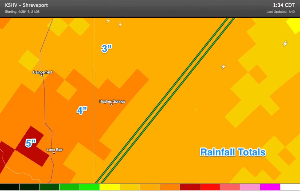
Evacuations were prompted in the towns of Kilgore and Hughes Springs, Texas. Homes were flooded in the Gin City community near Bradley, Arkansas. Vehicles stalled in high water in Caddo Parish, Louisiana, and a mudslide blocked a road in Plain Dealing, Louisiana. A cooperative observer southeast of Marshall, Texas, reported over 9 inches of rain Friday. Street flooding became widespread Saturday morning in Lake Charles, Louisiana.
Early Saturday, 60 mph wind gusts shifted and damaged two planes at Austin-Bergstrom International Airport. Windows were also blown out of a few homes in Bastrop County from 75 mph winds, and high winds overturned a semi on I-35 near Kyle, Texas, shutting down the northbound lanes for a time. Some trees were downed in the far north Houston metro area in Montgomery and northern Harris Counties.
For the more news on the latest impacts from the severe storms and heavy rain, click the link below.
(LATEST NEWS: Severe Storms, Flooding Impacts)
The most intense thunderstorms could produce large hail, damaging wind gusts, and possibly tornadoes. In addition, multiple rounds of rainfall is likely to trigger flash flooding, especially in already saturated locations such as eastern Texas and Louisiana.
The National Weather Service has posted flash flood watches for portions of eastern Texas, southeastern Oklahoma, Louisiana, Arkansas, Mississippi and west Tennessee.
Scroll down for an overview of the timing and impacts for the severe storm and flood threat into the weekend.
Radar, Watches, Warnings
Current Radar with Watches and Warnings
See below for a guide to watch and warning colors.
Guide to Watches and Warnings
(MORE: View National Interactive Radar Map | Difference Between a Watch and a Warning)

Severe Weather Outlook

Saturday
  • Severe thunderstorms are possible from the mid-Mississippi Valley and Lower Ohio Valley to the northern Gulf Coast.
  • Threats: Damaging wind gusts, large hail and perhaps a few tornadoes. How much severe weather there will be remains uncertain given the widespread nature of clouds and rain which may hold down instability. Once again, heavy rainfall also will be a concern and could cause flooding in parts of Arkansas, east Texas, Louisiana and Mississippi and west Tennessee.
  • Cities: Houston | Memphis | New Orleans
Saturday's Thunderstorm Forecast
Areas shaded red have the greatest chance of seeing severe weather.
Sunday: 
  • Locally heavy rain and a few severe storms may impact a swath from the mid-Atlantic and Southeast to the Gulf Coast.
  • Overall the potential for severe storms will be much lower than previous days, however gusty winds and hail will still be possible. Heavy rain may also cause localized flash flooding, particularly in the Lower Mississippi Valley and near the Gulf Coast, saturated from the past few days of heavy rain.
Monday:
  • Once again, any severe t-storms should be relatively few and far between from the eastern Carolinas to south Texas.
  • However, areas of locally heavy rain and flash flooding may persist in the Lower Mississippi Valley and western/northern Gulf Coast.
Below is the rainfall forecast through Monday. Keep in mind that locally heavier amounts of rain can fall in short periods of time than what is shown on the map.
The heavy rain falling on already saturated ground is likely to produce additional flooding.
Rainfall Forecast
Rainfall Forecast
Keep in mind that locally heavier amounts of rain are possible.

5 Dead in Texas Flooding; High Winds Damage Jet Planes as Severe Weather Continues Across Region

Published: 
Apr 30 2016 12:30 PM EDT
By Ada Carr
weather.com

5 Dead, Including 4 Children, in Texas Flooding

A 64 year old woman and four of her grandchildren have been reportedly killed in overnight flash flooding in Palestine, TX 
Rising flood waters claimed the lives of five, including four children, in Palestine, Texas, early Saturday morning.
At least two people were injured Friday night after tornadoes touched down in parts of Texas and Oklahoma. The twisters were part of a potent storm system punching into a large portion of the South and flash flood warnings continue to be a concern along the Gulf coast region.
Friday a tornado was reported in Sherman, Texas, with no immediate reports of injuries or damages. A second tornado was reported in Lindale, causing injuries and multiple damages to structures in the area.
According to the National Weather Service, a tornado moving at 30 mph was reported in Elgin, Oklahoma, late Friday afternoon. Large hail accompanied the storm, and damages were reported in the area.
(FORECAST: More Severe Thunderstorms, Flooding Rain Target South, Mississippi Valley)
Here are the latest state-by-state impacts.

Texas

In the eastern Texas town of Palestine, a grandmother and her four grandchildren were swept away by flood waters, NBCDFW reports. The bodies of the five victims were discovered by police in the 100 Block of Timber Drive early Saturday morning as officials were responding to reports of rising flood waters. 
 
"We are devastated because of it. I believe we're still missing one person that is just outside the city limits," Palestine Assistant Fire Chief Kyle Betterton told The Weather Channel. "Everybody is working feverishly, using every resource they can to get to the people and help the people."
 
According to KTBS, there were reports that the flood waters had reached as high as the roofs of houses and evacuations were underway. The woman was 64 years old while the children were 9, 8, 7 and 6 years old, but their identities have not yet been released. 
 
Two Boeing 737s were damaged at their terminal gates at Austin Bergstrom International  Airport Saturday morning as the storms moved through the area. Winds of more than 60 mph pushed both planes around, landing one on top of a baggage handling vehicle. 
 
In Cass County, several high water rescues were underway Saturday morning in the town of Hughes Springs, the NWS reports, and families are being evacuated to the civic center in town.
 
The flooding was strong enough to rip railroad ties from the tracks in the middle town and wash them out into the streets. Numerous roads have been flooded in Henderson County as well.
Cass County: Car submerged on Pecan Circle, in Hughes Springs. Some evacuations from apartments.
 
The NWS also reported that the storm blew out windows in Bastrop County Saturday morning. An emergency manager said there was widespread damage, including numerous torn off roofs and blown out windows. Structural damage was done to homes and businesses, and numerous trees and power lines were downed. 
Friday a tornado was reported in Sherman. There were no immediate reports of injuries or damages. A second tornado was reported in Lindale, leaving at least two people injured and causing multiple damages to structures in the area.
In Upshur County, 15 to 20 homes have reportedly been damaged or destroyed, according to the Associated Press. There were no immediate reports of injuries in the area.
A large tree was downed on top of a home and roof debris was scattered in front of a local Dollar Tree in Lindale, KYTX reports. Several power lines were also downed, contributing to the spread of outages.
Smith County Sheriff Larry Smith told AP that several injuries have been reported as a result of the Lindale tornado, but fallen tree limbs and power lines have slowed first-responders from reaching some areas.
As of Friday evening, Oncor reported 6,000 of its customers were experiencing outages, KYTX also reports. Upshur Rural reported 1,400 customers without power and Swepco reported 485.
The Mayfest grounds in Fort Worth's Trinity Park were evacuated due to reports of a thunderstorm packing hail, the Associated Press reports.
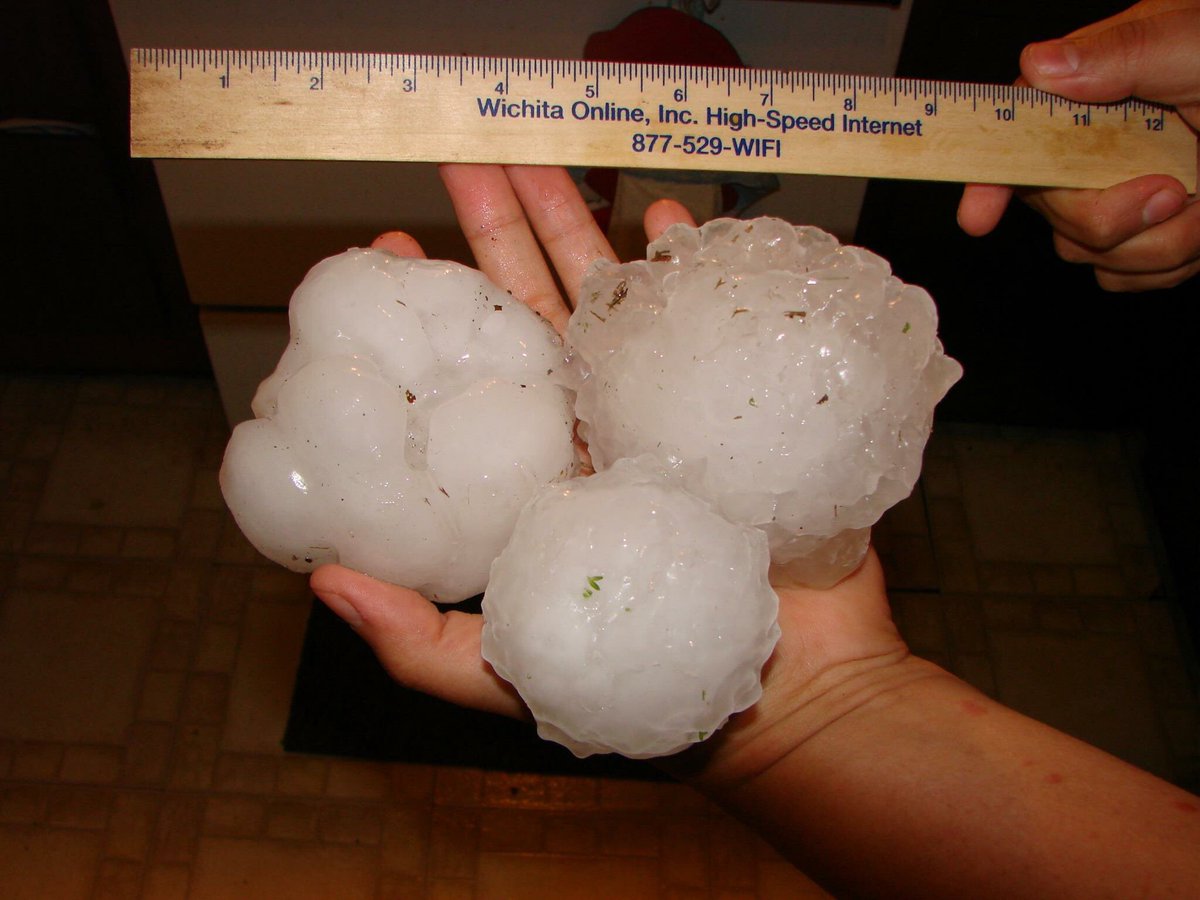
NWS reported hail the size of golf balls in Tyler, Texas, Friday. Residents took to social media to share photos of the barrage.
Severe storm produces large on west side of just after noon via @docdeason pic.twitter.com/mz3YyfxLG5 https://twitter.com/docdeason/status/726103454746173440 …

Oklahoma 

Friday the Oklahoma Highway Patrol shut down a nearly 20-mile stretch of Interstate 35 between Purcell and Norman. The closure went into effect after tornadoes and heavy hail was reported in the area.
OHP Capt. Paul Timmons told the Associated Press that the main north-south interstate has been shut down from mile marker 98 near Purcell to Tecumseh Road in north Norman. The closure came at the height of the Oklahoma City-area rush hour.
The city of Elgin and nearby areas saw damage after a reported tornado and hail near the size of the grapefruits were reported in the city.
Nearly GRAPEFRUIT SIZE HAIL north of Lake Lawtonka at 3:35pm. Photo: Kristal Moreland Cooper @NWSNorman

Strong winds flipped a trailer, but its occupants were not injured, Comanche County Emergency Management spokeswoman Ashleigh Hensch told the Associated Press. One of the occupants was sent to the hospital to be treated for anxiety. Roofs of homes and fences in nearby Fletcher also sustained minor damage.
Gusting winds flipped a semi on the H.E. Bailey Turnpike in the area where the tornado was spotted, according to KTUL.
The reported tornado totally destroyed a mobile home on Sooner Road in Ninnekah, spilling debris out into the street,  FOX 25 reports.
Highway 81 in Ninnekah also saw damages caused by winds after four power poles were snapped at their bases.
Heeding warnings of severe weather, school officials with Moore Schools canceled all activities scheduled for Friday night.
Del City High school also canceled events due to the weather, deciding to reschedule a basketball game and senior night for Monday.
Hail more than 3 inches in diameter was also reported north of Manitou on Friday, NWS reports.

Mississippi

Strong winds in Mississippi downed trees across roadways in the Wren area, where a wall cloud was spotted, NWS also reports.

Arkansas

Water rescues were underway in western portions of Lewisville Saturday morning according to the NWS, and several homes in Gin City are underwater as well.
On Friday, strong winds blew through Greenbrier, badly damaging the second story and roof of a bed-and-breakfast, the NWS also reported.
The onslaught of weather continued, with flooding inundated parts of Arkansas, leaving residents along MacArthur Drive in North Little Rock without electricity Friday, according to KATV.
Fort Smith Police told 4029 News that there has been extensive hail damage in the southern part of the city. Sizeable hail was also reported in Sebastian County.
Fort Smith Police report extensive hail damage in south Fort Smith.

Louisiana

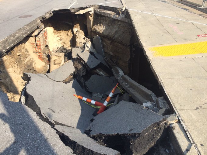
Heavy rains and leaking water pipes caused a portion of Canal Street to collapse Friday, WVUE reports. The large sinkhole opened up near Harrah's Hotel and Casino.
"This is nothing short of incredible," said Mayor Mitch Landrieu during a news conference. According to Landrieu, repairs should take three to six months and cost up to $5 million.
Couple shots from the edge of the hole in Canal Street