By Alex Sosnowski, AccuWeather senior meteorologist
June 23,2017, 7:42:41PM,EDT
Multiple systems, including Tropical Rainstorm Cindy, will combine forces to raise the risk of flash flooding in parts of the northeastern United States into Saturday.
A surge in warmth and humidity will meet up with a press of cooler air from the Midwest. At the same time Tropical Rainstorm Cindy will move along the boundary between the warm and cool air.Initially, locally severe thunderstorms will erupt. A few communities can be hit with damaging wind gusts. The pattern will evolve into a heavy rain setup late Friday night.
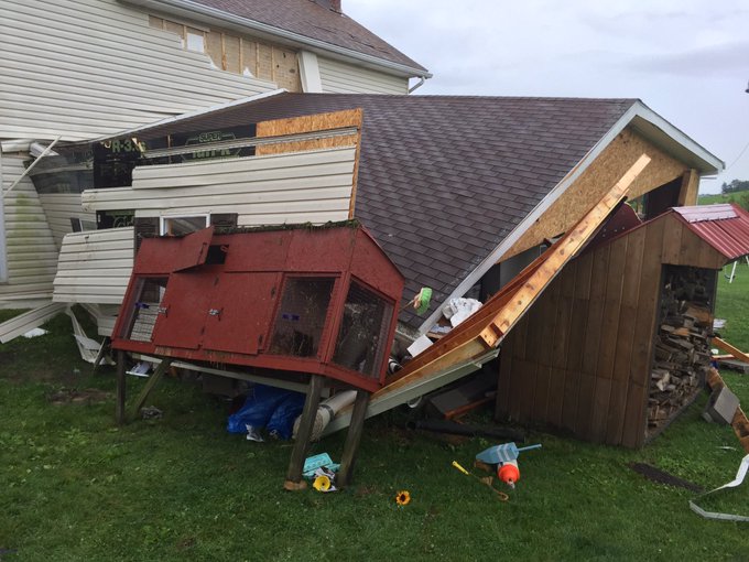
Some gusty storms brought down trees from Pennsylvania to Kentucky on Friday afternoon before the threat shifted to flooding downpours.
Several inches of rain fell from Pittsburgh through Cincinnati leading to widespread flooding.
Storm rolled
in around 3:30 pm. The high winds took out this garage on Brush Run
Road in Washington. Ten bunnies in cage survived. @WTAE
While downpours can occur with any shower
or thunderstorm throughout the Northeast into Saturday morning, there is
a zone that may be at greater risk for flooding.
"As moisture from Tropical Rainstorm Cindy sweeps through, areas from Ohio, Kentucky and Tennessee to West Virginia, Pennsylvania, northern Maryland, northern New Jersey and coastal New York state could have periods of torrential rain from later Friday night to Saturday morning," according to AccuWeather Senior Meteorologist Dave Dombek.

From Washington, D.C., to Baltimore, Philadelphia, New York City and other metro areas in the region, the most common problem from the downpours will be urban flooding, where water collects in poor drainage areas of streets and highways.
"At the very least, people traveling in the Northeast should anticipate downpour-related delays into Saturday," Dombek said.
RELATED:
Cindy’s major flood threat to persist as storm unleashes up to a foot of rain
AccuWeather Severe Weather Center
3 lesser known summer dangers
In the heaviest downpours, a couple of inches of rain can fall in as many hours. For some communities this is above the threshold for flash flooding to occur, due to the state of the soil and topography. This is especially true for parts of the central Appalachians and eastern parts of the Ohio Valley.
People should avoid setting up their campsite along small streams or the banks of larger rivers as water levels could rise quickly in this situation into Saturday.
Any downpours that track near Indiana, Pennsylvania, could quickly renew flooding that occurred after heavy thunderstorms soaked the area on Thursday afternoon. Over 4 inches of rain fell locally, which led to dozens of high-water rescues.
One man was killed in Indiana, Pennsylvania, as he attempted to clear out a debris-filled pipe while in a kayak, according to the Pittsburgh-Post Gazette. The pond he was kayaking on rose rapidly after the storms unleashed torrents of rain.
He became stuck in the pipe and submerged by water. Bystanders, including his father, were not able to free him.
The risk of flash flooding will end while cool, dry air from the Upper Midwest advances southeastward as the weekend progresses.

By early next week, it will feel more like the middle of September, rather than the end of June for many people.


No comments:
Post a Comment