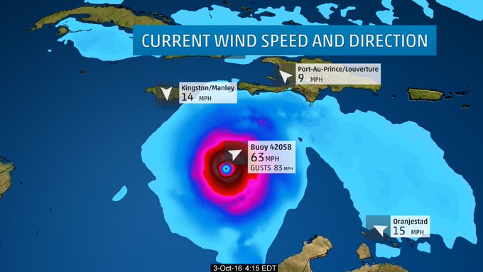
Hurricane Matthew is threading the gap between Haiti and Cuba, but parts of eastern Cuba and the Bahamas are next in line for hurricane force and tropical storm force winds. Hurricane watches have been expanded for the East Coast of Florida.
(MORE: Hurricane Central | Interactive Storm Tracker Map)
Matthew is increasingly likely to have significant impacts along the Southeast U.S. coast later this week. Those impacts may start to arrive in Florida as early as Thursday, potentially spreading northeast to coastal Georgia and the coastal Carolinas Friday into the weekend.
All interests in the coastal Southeast states should continue to monitor the forecast closely and make necessary preparations for a hurricane.
(MORE: U.S. Impacts From Matthew)
Hurricane Matthew's eye came ashore in the western Tiburon Peninsula of Haiti near the town of Les Anglais around 7 AM EDT, according to the National Hurricane Center. The eye is now moving toward the eastern tip of Cuba.
A hurricane watch has been issued for the east coast of Florida from Golden Beach, Florida to the Volusia/Brevard County line in Florida. Lake Okeechobee has also been placed into a hurricane watch.
A tropical storm watch has also been issued from the Seven Mile Bridge in the Florida Keys northward to Golden Beach, Florida.
Hurricane warnings were expanded Tuesday morning to include the northwest Bahamas, including Nassau and Freeport. Hurricane warnings now include the entire Bahamas chain, as well as eastern Cuba and Haiti.
Current Watches/Warnings
Latest Status
Hurricane Matthew is moving northward as a strong and extremely dangerous Category 4 hurricane, with its eyewall currently hammering eastern Cuba and western portions of Haiti.(MORE: Guantanamo Bay, Cuba Radar)
Current Storm Status
Current Wind Speed and Gusts
Peak Impact Timing
Some fluctuations in intensity are possible over the next couple of days, but Matthew will likely remain a powerful hurricane the next several days.Here is the approximate timing of the worst wind and surge impacts, coinciding with the nearest passage of the eyewall of Matthew.
Projected Path and Intensity
- Haiti/Dominican Republic: Through Tuesday
- Eastern Cuba: Late Tuesday through early Wednesday
- Southeast & central Bahamas: Tuesday night through early Thursday
- Northwest Bahamas: Wednesday night through Thursday night
- Southeastern/Eastern Florida: Late Thursday through early Friday
- Northeastern Florida: Early Friday through Friday Evening
Note that even though certain locations may not be in the cone of uncertainty, impacts will be spread well beyond the edge of the cone.
(MORE: Facts/Myths About the Hurricane Cones of Uncertainty)
Caribbean Impacts
Hispañola (including Haiti) will see the worst wind and surge impacts from Matthew Tuesday. Impacts are beginning to wane in Hispaõla, but mudslides may continue for days.Eastern Cuba will see conditions steadily go downhill Tuesday evening, making preparations difficult, there.
(NEWS: Latest Caribbean Impacts)
Over a foot of rainfall from Matthew will trigger life-threatening flash floods and mudslides. In Haiti, in particular, heavy rainfall could be catastrophic. Here are the latest rainfall projections from the National Hurricane Center:
- Southern Haiti, southwest Dominican Republic: 15 to 25 inches, locally up to 40 inches
- Northwestern Haiti, eastern Cuba: 8 to 12 inches, locally up to 20 inches
- Eastern Jamaica: 4 to 6 inches, locally up to 12 inches
- The Bahamas: 8 to 12 inches, locally up to 15 inches
- Turks and Caicos: 2 to 5 inches, locally up to 8 inches
- Northeast Haiti, rest of the Dominican Republic: 1 to 3 inches, locally up to 5 inches
- Western Jamaica: 1 to 2 inches, locally up to 3 inches
- Upper Florida Keys and much of the Florida East Coast: 4 to 7 inches, locally up to 10 inches
- Middle to Lower Florida Keys: 1 to 3 inches, locally 5 inches.
Forecast Rainfall
- The Bahamas: 10 to 15 feet
- South coast of Cuba east of Cabo Cruz: 7 to 11 feet
- South coast of Haiti: 7 to 10 feet
- North coast of Cuba east of Camaguey: 4 to 6 feet
- Gulf of Gonave (Haiti): 3 to 5 feet
- Jamaica: 2 to 4 feet
- South coast of the Dominican Republic: 1 to 3 feet
- Florida east coast from North Palm Beach to the Volusia/Brevard County Line: 3 to 5 feet
(FLASHBACK: Hurricane Joaquin 2015)
Battering waves will ride atop the storm surge, and coastal flooding from large waves may begin well in advance and ahead of Matthew's center.
This storm surge will also limit rainfall runoff in some places, aggravating flooding, especially in coastal locations where swollen rivers cannot drain.
Hurricane-force winds, with peak timing as outlined above, will lead to widespread structural damage, particularly to poorly-built structures, numerous downed trees and widespread power outages. Due to wet ground, trees will be even more susceptible to being toppled.
One possible analog to Matthew is Hurricane Hazel, which swept through Haiti in October 1954, claiming 400-1,000 lives from severe flash flooding and landslides.
U.S. Threat
Forecast guidance began to trend Monday toward a closer pass of Matthew to the Southeast coast, from Florida to North Carolina. This trend has continued into Tuesday.The reason for this is stronger high pressure aloft persisting over the western Atlantic and East Coast of the U.S. helping to trap Matthew closer to the coast.
(NEWS: Southeast U.S. on Alert)
 Upper-level steering factors in play for Matthew later this week.
Matthew is expected to still be a formidable hurricane through at least its journey near or over the Southeast into the weekend.
The severity of any direct impacts (particularly from wind) will depend on how close the center of Matthew moves near the southeastern states.
Right now, it appears at least tropical storm-force winds are a good bet from most of Florida's East Coast to at least North Carolina's Outer Banks.
Uncertainty is best summarized by the 5:00 p.m. forecast from the National Hurricane Center:
When a hurricane is forecast to take a track roughly parallel to a coastline, as Matthew is forecast to do from Florida through South Carolina, it becomes very difficult to estimate impacts this far in advance. For example, only a small deviation of the track to the left of the NHC forecast could bring the core of a major hurricane onshore, while a small deviation to the right could keep all of the hurricane-force winds offshore. It will likely take another day or so for the potential impacts of Matthew in the United States to clarify.The eyewall of Matthew could get close enough to shore that hurricane-force winds could come ashore on the Florida Eas Coast. That is becoming an increasing possibility from eastern Florida to the Carolinas.
Hurricane Force Wind Probabilities
Matthew will then accelerate northeast this weekend. While, again, the exact path will determine impacts, at least a chance of tropical storm-force winds and heavy rain is in play up the Mid-Atlantic and New England coast, eventually into Nova Scotia or New Brunswick, Canada.
Even if Matthew stays well offshore any part of the East Coast, dangerous swells, coastal flooding and beach erosion are likely, particularly from the Virginia Tidewater south late this week into the weekend.
All interests along the U.S. East Coast and Atlantic Canada should monitor the progress of Matthew closely. Now is a good time to make sure you're prepared before the storm. Are you #HurricaneStrong?
Check back with us frequently at weather.com for any important forecast updates.
Storm Reports, Recap
George F.L. Charles Airport on St. Lucia picked up 9.21 inches of rain Wednesday. On the south side of the island, Hewanorra Int'l Airport picked up 13.19 inches of rain in just 12 hours from 8 p.m. Wednesday through 8 a.m. Thursday, according to the Antigua Met Service.(MORE: Category 5 Hurricanes Prior to Matthew)
Hurricane Matthew became the fifth hurricane of the 2016 Atlantic hurricane season early Thursday afternoon.
According to Colorado State University tropical scientist Dr. Phil Klotzbach, Matthew became the lowest latitude Category 5 hurricane in the Atlantic on record (beating the old record set by Ivan in 2004).
Some outer rainbands triggered flash flooding in Jamaica Sunday, hundreds of miles away from the center of Matthew.
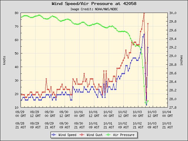
Interestingly Sunday night, a fortunately-placed NOAA buoy sampled Matthew's eye, providing valuable information for meteorologists.
4:20am ET: Buoy 42058 Winds rebounding quickly in the southern eyewall. #Matthew
Min pressure from the eye pass: 942.8mb.
Min pressure from the eye pass: 942.8mb.


No comments:
Post a Comment