Hurricane Matthew's potentially catastrophic strike on Haiti is imminent, and it will also impact parts of Jamaica, eastern Cuba and the Bahamas.
Late this week and into the weekend, portions of the coastal southeastern U.S. states could see impacts from Matthew. Interests from Florida to the coastal Carolinas should monitor the progress of Matthew very closely.
The National Hurricane Center (NHC) said in its 5 p.m. advisory Monday, "While there remains significant uncertainty in the track of Matthew in the long range, the threat to Florida and the southeastern U.S. coast has increased."
(MORE: 55,000 Displaced Haitian Residents Could Be in Danger)
Hurricane warnings are in effect for Haiti, eastern Cuba, the southeastern Bahamas (including the Inaguas, Mayaguana, Acklins, Crooked Island, Long Cay and Ragged Island) and the central Bahamas (including Long Island, Exuma, Rum Cay, San Salvador and Cat Island).
Hurricane watches continue for the Turks and Caicos Islands, the Cuban province of Camaguey and the northwestern Bahamas, including the Abacos, Andros Island, Berry Islands, Bimini, Eleuthera, Grand Bahama Island and New Providence.
Current Watches/Warnings
Latest Status
Hurricane Matthew is moving slowly northward as a strong and extremely dangerous Category 4 hurricane, located about 100 miles south of Tiburon, Haiti.(MORE: Hurricane Central | Interactive Storm Tracker Map)
Current Storm Status
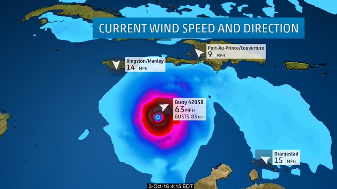
Current Wind Speed and Gusts
Peak Impact Timing
Here is the approximate timing of the worst wind and surge impacts, coinciding with the nearest passage of the eyewall of Matthew.Projected Path and Intensity
- Jamaica: Into Tuesday morning
- Haiti/Dominican Republic: Through Tuesday
- Eastern Cuba: Late Tuesday/Tuesday night
- Southeast & central Bahamas/Turks & Caicos: Tuesday night into at least Wednesday night
Note that even though certain locations may not be in the cone of uncertainty, impacts will be spread well beyond the edge of the cone.
(MORE: Facts/Myths About the Hurricane Cones of Uncertainty)
Caribbean Impacts
Jamaica and Hispañola (including Haiti) will see the worst wind and surge impacts from Matthew into Tuesday. Eastern Cuba has already begun seeing initial tropical storm-force gusts and outer rainbands, so this could make preparations difficult, there.Over a foot of rainfall from Matthew may trigger life-threatening flash floods and mudslides. In Haiti, in particular, heavy rainfall could be catastrophic. Here are the latest rainfall projections from the National Hurricane Center:
- Southern Haiti, southwest Dominican Republic: 15 to 25 inches, locally up to 40 inches
- Northwestern Haiti, eastern Cuba: 8 to 12 inches, locally up to 20 inches
- Eastern Jamaica: 5 to 10 inches, locally up to 15 to 20 inches
- The Bahamas: 8 to 12 inches, locally up to 15 inches
- Turks and Caicos: 2 to 5 inches, locally up to 8 inches
- Northeast Haiti, rest of the Dominican Republic: 1 to 3 inches, locally up to 5 inches
- Western Jamaica: 1 to 3 inches, locally up to 6 inches
Forecast Rainfall
- The Bahamas: 10 to 15 feet
- South coast of Cuba east of Cabo Cruz: 7 to 11 feet
- South coast of Haiti: 7 to 10 feet
- North coast of Cuba east of Camaguey: 4 to 6 feet
- Gulf of Gonave (Haiti): 3 to 5 feet
- Jamaica: 2 to 4 feet
- South coast of the Dominican Republic: 1 to 3 feet
(FLASHBACK: Hurricane Joaquin 2015)
Battering waves will ride atop the storm surge, and coastal flooding from large waves may begin well in advance and ahead of Matthew's center.
This storm surge will also limit rainfall runoff in some places, aggravating flooding, especially in coastal locations where swollen rivers cannot drain.
Hurricane-force winds, with peak timing as outlined above, will lead to widespread structural damage, particularly to poorly-built structures, numerous downed trees and widespread power outages. Due to wet ground, trees will be even more susceptible to being toppled.
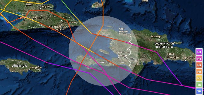
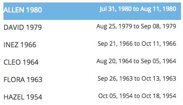
It's worth noting only six other Category 3 or stronger hurricanes have tracked within 100 nautical miles of central Haiti since 1954. The last to do so was Allen in 1980, though Hurricane Ike in 2008 passed within 100 nautical miles of the north coast of Haiti, and Hurricane Gilbert in 1988 did so within the south coast of Haiti.
NOAA's hist. hur tracks: Only 6 other Cat. 3+ #hurricanes have tracked w/in 100 nm of ctrl #Haiti since 1950. Allen (1980) last. #Matthew
U.S. Threat?
Beyond that, it remains uncertain how close Matthew's eyewall will pass near the northwest Bahamas later Thursday into Friday, and it is still too soon to determine how big the danger will be in parts of the U.S. late this week and next weekend.(MORE: Why Long-Range Model Forecasts For the Tropics Can't Often Be Trusted)
For now, ensemble forecast guidance suggests we can't rule out at least tropical storm-force winds along the eastern Florida coast in the Thursday-Friday timeframe.
Tropical Storm Force Wind Probabilities
- Bigger U.S. coastal threat: Stronger and/or later-departing upper high pressure system off/near the Northeast coast with weaker and/or later-arriving upper-level trough from the Plains.
- Lower U.S. coastal threat: Weaker and/or faster-departing upper high pressure system off/near Northeast coast with stronger and/or faster-arriving upper-level trough from the Plains.
That said, the forecast remains highly uncertain, which is not uncommon for a forecast beyond 4 days out. The severity of any impacts will depend on how close the center of Matthew moves near the southeastern states.
Even if Matthew stays well to the east of Florida and the East Coast, dangerous swells, coastal flooding and beach erosion are likely, particularly from the Virginia Tidewater south late this week into the weekend.
We also cannot yet rule out a close call for the rest of the Northeast seaboard, including New England and even Atlantic Canada, later this weekend.
All interests in the Caribbean Sea, Bahamas, U.S. East Coast and Atlantic Canada should continue to monitor the progress of Matthew. Preparations in Jamaica, Haiti, Cuba and the Bahamas should be well underway.
Check back with us frequently at weather.com for any important forecast updates.
Storm Reports, Recap
George F.L. Charles Airport on St. Lucia picked up 9.21 inches of rain Wednesday. On the south side of the island, Hewanorra Int'l Airport picked up 13.19 inches of rain in just 12 hours from 8 p.m. Wednesday through 8 a.m. Thursday, according to the Antigua Met Service.(MORE: Category 5 Hurricanes Prior to Matthew)
Hurricane Matthew became the fifth hurricane of the 2016 Atlantic hurricane season early Thursday afternoon.
According to Colorado State University tropical scientist Dr. Phil Klotzbach, Matthew became the lowest latitude Category 5 hurricane in the Atlantic on record (beating the old record set by Ivan in 2004).
Some outer rainbands triggered flash flooding in Jamaica Sunday, hundreds of miles away from the center of Matthew.
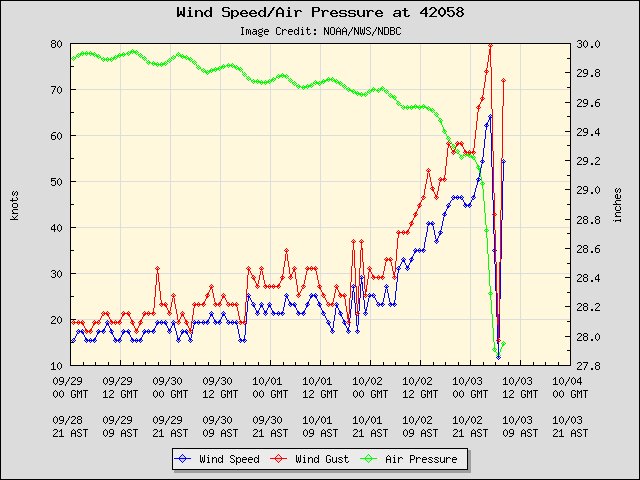
Interestingly Sunday night, a fortunately-placed NOAA buoy sampled Matthew's eye, providing valuable information for meteorologists.
4:20am ET: Buoy 42058 Winds rebounding quickly in the southern eyewall. #Matthew
Min pressure from the eye pass: 942.8mb.
Min pressure from the eye pass: 942.8mb.
MORE: Hurricane Matthew Barrels Through the Caribbean


No comments:
Post a Comment