Published: April 22,2016
(MORE: Where Have April's Tornadoes Gone?)
 Upper-level pattern setting up next week.
Why We're Concerned: The Setup
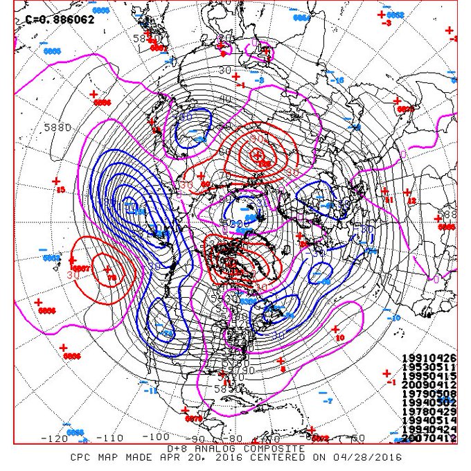
In general, spring severe outbreaks are triggered when a southward dip in the jet stream, or upper-level trough, surges east into the Plains states.That precise pattern looks to be shaping up next week.
In fact, there appear to be three distinct upper-level disturbances embedded in that general trough that each will help ignite rounds of severe thunderstorms through next weekend.
Ahead of each upper disturbance, progressively richer moisture from the Gulf of Mexico will push northward, adding to instability from the pockets of cold, dry air aloft.
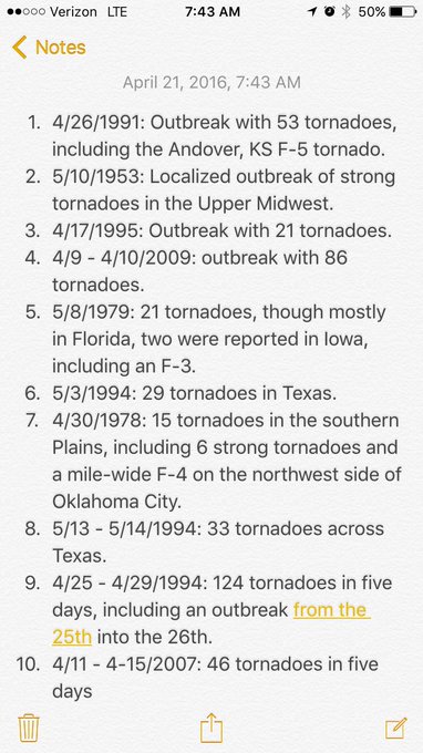
Examining analogs, or past weather patterns most similar to the forecast pattern next week, storm chaser and former weather.com digital meteorologist Quincy Vagell found five of the top 10 analogs were tornado outbreaks.
(MORE: Why April is a Dangerous Month)
Increasingly dramatic signal for severe potential ahead. Top 10 analogs all active periods; 5 outbreaks.(#1 4/26/91)
Severe Outlook
In any severe weather forecast several days out, there are key uncertainties, such as the amount of sunshine increasing instability the day of the event, that can affect the overall coverage and severity of severe weather.(INTERACTIVE: Your 7-Day Severe Weather Outlook)
Therefore, check back with us at weather.com for the latest on this potential severe weather as our forecasts come into focus in the days ahead.
For now, here's an outlook of potentially the most active severe weather periods next week.
Sunday
- Isolated to scattered severe t-storms from the Corn Belt of Iowa into parts of the southern Plains.
- Overall outbreak potential: Not expected
- Threats: Large hail, damaging winds, possibly a tornado or two

Sunday's Thunderstorm Outlook
- More widespread severe t-storms in parts of the central and southern Plains.
- Overall outbreak potential: Moderate to high
- Threats: Tornadoes (possibly strong/long-track), large hail, damaging winds

Tuesday's Thunderstorm Outlook
- Severe t-storms could again be rather numerous from the mid-Mississippi Valley to the southern Plains
- Overall outbreak potential: Moderate
- Threats: Tornadoes, large hail, damaging winds

Wednesday's Thunderstorm Outlook
- Once again, more widespread severe t-storms are possible in the central and southern Plains, possibly extending east into parts of the Mississippi Valley.
- Severe t-storms are possible each day in these areas Thursday into next weekend (Apr. 30 - May 1).
- Overall outbreak potential: Too soon to tell, but could be at least moderate on one or more days.
The uncertainty about late next week centers primarily around the timing of when the entire western upper-level trough pushes east out into the Plains states, which would dictate when the most widespread severe thunderstorm threat (possible outbreak) would occur.
Now is a good time to refresh your memory on severe weather preparedness.
(MORE: 7 Things You Should Never Forget When Tornadoes Threaten | Tornado Safety Page)
Do you know where to go in your home, condo, apartment, office or school when a tornado warning is issued? What if you're caught out in the open?
The time to have a tornado safety plan is now, before a tornado strikes.


No comments:
Post a Comment