Published: April 17,2016
A stalled storm system will continue to produce additional heavy rainfall over a broad swath of the Plains, triggering potentially serious flash flooding in parts of Texas, Oklahoma, Kansas and Nebraska.
In some parts of the High Plains, the average rainfall for April has been doubled in just a couple of days. This includes Dodge City, Kansas, which picked up 4.77 inches of rain Saturday into Sunday afternoon, more than doubling their April average of 1.82 inches. Northeast of Dodge City in Ellis County, a few roads were washed out by flooding.
(INTERACTIVE: Where the Heavy Rain is Now)
Now the dangerous flood threat is targeting locations farther to the South, particularly Texas. Flash flooding was reported Sunday morning in Clifton, Texas, causing several vehicles to stall out and several roads in central Bastrop county in Texas were closed on Sunday due to flash flooding.
(NEWS: Flooding, Severe Weather Impacts)
Below are more forecast details.
Dangerous Flood Threat Continues
Flood watches have been issued for periods of heavy rainfall for a large portions of the southern and central Plains from Texas northward into central Kansas, as well as an area in southern South Dakota. The heavy rain will cause roads, as well as streams and rivers to flood, especially in flood prone areas. Do not attempt to drive through flooded roadways should you encounter one.
Flood Alerts
(FORECASTS: Oklahoma City | Dallas | Austin | San Antonio | Houston)
The map below is a general view of the area where we're expecting the heaviest rain into Tuesday. Some locations could pick up 5 to 8 inches of total rainfall. Keep in mind locally much heavier amounts may fall where bands of rain or thunderstorms stall for a few hours at a time.

Rainfall Outlook Through Tuesday Night
(FORECAST: Severe Weather Threat Through Early Week)
Rainfall Totals So Far
Numerous reports of roads flooded in Texas and Kansas have already been received. Here is a list of notable rainfall totals by state, as of Sunday afternoon:- Kansas: 5.1 inches in Atwood
- Nebraska: 5.08 inches near McCook
- Oklahoma: 7.0 inches in Frederick
- Texas: 4.25 inches near Bastrop, Texas
What's Causing the Heavy Rain?
Sometimes, winds at jet-stream level don't simply flow generally west to east (in the northern hemisphere), but rather take large north-south (or south-north) meanders. When this happens, weather systems producing rain or snow slow down. Upper-level
pattern forecast for Sunday, April 17, 2016, featuring an omega block
in the East, trapped low in the Rockies, and deep moisture into the
Plains states.
Upper-level
pattern forecast for Sunday, April 17, 2016, featuring an omega block
in the East, trapped low in the Rockies, and deep moisture into the
Plains states.(MET 101: "Omega Block" Brings Welcomed Warm-Up)
With high pressure both to the northwest and northeast of the stuck low, there's nowhere for the closed low to go fast.
On the east side of that swirling, slow-moving low, deep moisture is in place in the central states.
In general, the slower the trapped upper low moves, the greater the potential for heavy rain over the same areas over multiple days.
This stagnant pattern with a deep plume of moisture in place is a prime setup for flooding rainfall, even despite parts of the Plains being rather dry, recently (more on that below).
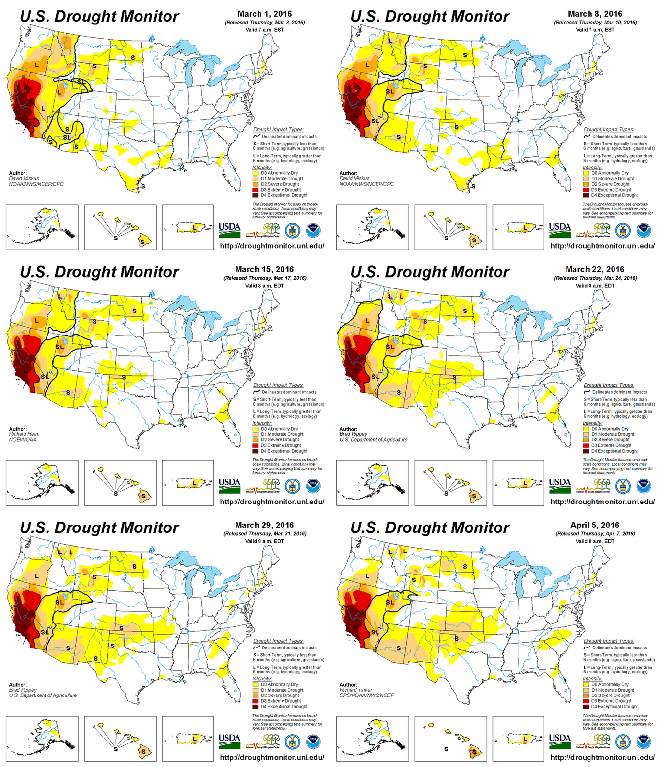
Yet Another Bizarre Flip-Flop
 Drought
monitor animation from March 1 through April 5, 2016, illustrating the
developing drought (light tan contour) in the Plains.
Drought
monitor animation from March 1 through April 5, 2016, illustrating the
developing drought (light tan contour) in the Plains.Garden City, Kansas, hadn't seen any measurable rain or snow in over two months since Groundhog Day, until they picked up almost three-tenths of an inch of rain Monday.
The combination of this complete lack of precipitation with persistently warm and windy weather this spring has led to several large wildfires, including the largest fire on record in Kansas, hopping across the border from Oklahoma in late March.
(RECENT FIRES: Imagery of March Wildfire | Early April NW Oklahoma Fire)
Finally, a wetter pattern more typical of early spring has taken shape, however, its extremely stagnant nature will lead to extreme precipitation totals in the High Plains, as we mentioned earlier.
Thanks to this sluggish, blocked pattern, Garden City, Kansas, could pick up perhaps twice the average April monthly precipitation, potentially even topping the average wettest month of the year, June.
No comments:
Post a Comment