Published: February 14,2016
Record warmth has been giving much of the West a very early summer preview, as temperatures have soared into the 80s and 90s. The change has been rather abrupt, as conditions more typical during an El Niño winter, has been replaced by dry and unseasonably warm conditions.
A nearly steady string of storm systems through the late fall and early winter brought much-needed rain to the region. Unfortunately, the current warm, dry spell has put further drought-relief on hold, at least in the short-term.

Setup Across the West
Summer in February
Dozens of record highs have been toppled over the past week across the Golden State, Desert Southwest and other parts of the West, as many locations have risen into the 80s and 90s. The warmth has been a staggering 15 to 25 degrees above average, even warmer than typical highs during the hottest months of the summer.Santa Ana tied an all-time record high temperature for the month of February on Tuesday after reaching 95 degrees.
It's not just warm in California, as neighboring states across the West have also felt the heat. On Monday, North Bend, Oregon, obliterated their daily record high by 13 degrees, after reaching 82 for a high temperature. That is a full 30 degrees above average for mid-February.
Quillayute, Washington, tied their February record high of 73 degrees and Choteau, Montana, topped their February high of 73 degrees Tuesday.
Phoenix, Arizona, also got in on the summer-like warmth by setting a daily record high of 86 degrees Tuesday, 85 degrees Thursday, and 87 degrees Friday. Flagstaff, Arizona, soared to 64 degrees for the second time in three days Friday, oddly with six inches of snow still on the ground at Pulliam Airport.
(MORE: Rare Superbloom in Death Valley)
Warm Weather Continues
Another surge of near-record heat returns for the beginning of this week thanks to a ridge of high pressure moving across the region.Downtown Los Angeles is forecast to reach the middle 80s Monday and Tuesday. This is well above the average high in the mid to upper 60s and within reach of the daily record high of 88 degrees both days.
San Diego will rise into the low 80s both Monday and Tuesday. The record high of 81 degrees for Tuesday (Feb. 16) will likely be threatened.

Forecast Highs Into Next Week
(FORECAST: Boise | Portland, Oregon | Spokane)
It appears that the weather pattern may break down by mid to late week, bringing temperatures back down to where they are expected to be for mid-February.

Forecast Highs Saturday to Monday
Record Temperatures This Past Week
Here is a sample of some of the California records that have been broken or tied so far this week.- Monday: Death
Valley (89 degrees); Los Angeles, Airport (89 degrees); Los Angeles,
Downtown (88 degrees); Santa Cruz (85 degrees); Oceanside (84 degrees);
Oakland (79 degrees); Napa (78 degrees); Sacramento, Airport (75
degrees); San Francisco, Downtown (75 degrees); Eureka (72 degrees); Mount Shasta City (70 degrees).
- Tuesday: Santa
Ana (95 degrees); Long Beach (92 degrees); Escondido (89 degrees);
Riverside (88 degrees, tied); Santa Barbara (85 degrees); Santa Cruz (85
degrees); San Diego (83 degrees); Monterey (80 degrees); San Jose (76
degrees); Sacramento, Airport (73 degrees); Oakland (70 degrees);
Sandberg (68 degrees); Mount Shasta City (68 degrees).
- Wednesday: Riverside
(90 degrees); Los Angeles, Downtown (88 degrees, tied); Santa Ana (88
degrees); San Diego (86 degrees); Los Angeles, Airport (85 degrees);
Crescent City (75 degrees); Oakland (68 degrees, tied).
- Thursday: Santa
Ana (86 degrees); San Diego (84 degrees); Oakland (74 degrees, tied);
Sacramento, Airport (73 degrees); Mount Shasta City (67 degrees, tied).
- Friday: Woodland Hills (90 degrees); Riverside (88 degrees, tied); Chula Vista (83 degrees tied).
- Monday: Santa Ana (75 degrees); Palm Springs (64 degrees); Riverside (60 degrees); Death Valley (59 degrees).
- Tuesday: Santa Ana (60 degrees, tied); Oceanside (57 degrees); Riverside (55 degrees).
- Thursday: Palomar Mountain (52 degrees).
What’s Happened to El Niño?
Residents across the West Coast were optimistic about the state of El Niño this winter, as the pattern is generally associated with above normal precipitation across the region.(MORE: What's Next for El Niño?)
While that was the case for much of November, December and even part of January, the so-called “atmospheric river” of moisture surging into the West has come to a screeching halt.
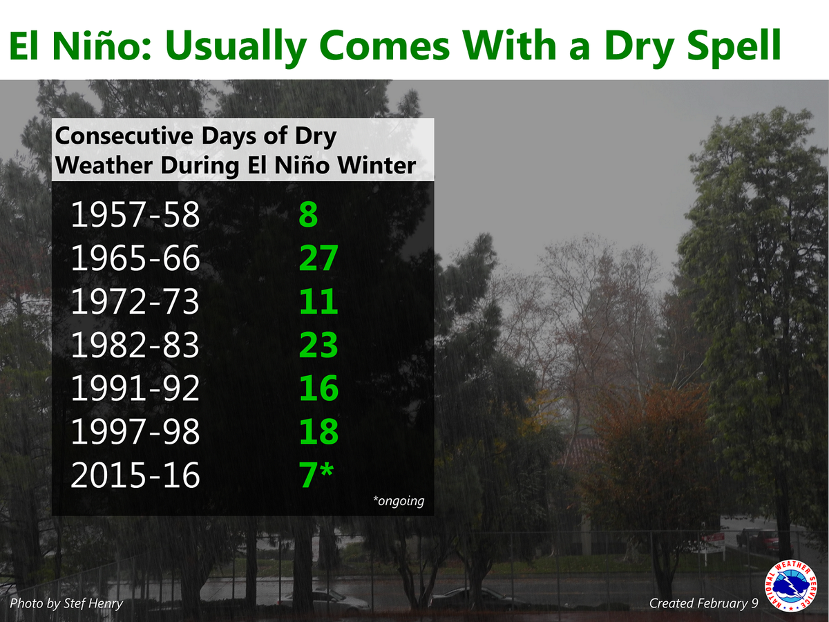
Even though El Niño is still present, it is not uncommon for California to experience bouts of dry weather amidst the generally stormy pattern. According to the National Weather Service office in Sacramento, there have been at least five stretches of more than 12 days without rain in the area amidst El Niño winters.
Dry spells during #ElNino winters are not uncommon. Most prior strong #Elnino have had long dry stretches! #cawx
Changes are anticipated by that time, as the jet stream should sink back to the south. This could bring a return to storminess across California for a time, a state still in dire need of additional rain and mountain snow.
MORE: Storms Flood Western States, January 2016


No comments:
Post a Comment