By Jordan Root, Meteorologist
January 3,2016; 8:50PM,EST
Evacuations are in order for thousands of residents along the Mississippi River as deadly flood waters continue to surge southward.
The river is expected to reach moderate or major flood stage at many river gauges in Tennessee, Arkansas and Mississippi, heading into the first week of 2016 and will remain at those levels throughout the week.
Dangerous conditions are expected as these flood waters will submerge highways and homes near the river. The river is expected to crest early this week along the border of northern Tennessee and Arkansas and towards the end of the week farther south into Mississippi.
Water levels in southern Louisiana will reach minor flood stage early this week, rising to moderate flood stage by the weekend and eventually cresting next week.
Those living downstream along the river will want to take action now and heed any evacuation order given by local officials.
Flooding may continue for a couple weeks in some areas as the water levels slowly recede.
December rain brings deadly flooding in Missouri and Illinois; St. Louis area left underwater
Highways were shut down and communities evacuated this past week in the St. Louis area as water levels quickly rose.
President Barack Obama approved Missouri Governor Jay Nixon's request Saturday night for a federal emergency declaration in the St. Louis area, stated a press release from the state of Missouri.
"The fast-rising flood water inundated several thousand homes and businesses and left behind a trail of destruction, debris and refuse that will have to be cleaned up quickly so that rebuilding can begin and the region can recover," Gov. Nixon said in the press release.
According to the Associated Press, two dozen people in Missouri and Illinois have died as a result of the flooding. Many died while attempting to cross flood waters in vehicles.
Interstate 44 and 55 which were once under water reopened south of St. Louis Friday, said the Associated Press.
The Mississippi River crested Friday in St. Louis and began to recede over the weekend, but still remains in flood stage. It will take a few more days before it drops below flood level.
RELATED:
Seven photos that capture the severity of the Missouri flooding
Year in review: Top 5 viral weather stories of 2015
Weekly wrap-up: Deadly flooding hits Missouri; December ends as warmest on record in eastern US
Nearby tributaries to it, including the Meramec River, also peaked at the end of the week and even set the record for highest crest at 44.11 feet. The Mississippi River at Cape Girardeau set a new record at 48.86 feet.
"Flooding on the middle portion of the Mississippi River and some of its tributaries reached levels not seen during the winter months since records began during the middle 1800s," said AccuWeather Senior Meteorologist Alex Sosnowski.
Illinois was also hit hard by flooding, which prompted Governor Rauner to issue a state of disaster proclamation for seven counties, according to a press release from the state of Illinois.
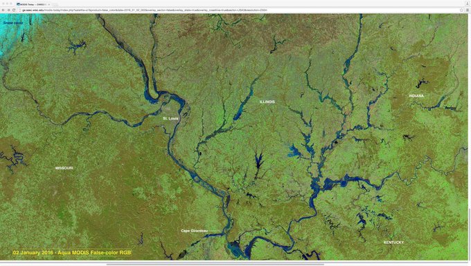
MODIS images revealing the extent of flooding in the MO/MS/OH River basins http://cimss.ssec.wisc.edu/goes/blog/archives/20382 … @NWSPaducah
December 2015 ended as the wettest December on record and added to an already impressive rain total for the year. This past year also set the wettest year on record in St. Louis, beating the old record by more than 3 inches.
"The pattern is typical of an El Niño, but rainfall of this magnitude has crossed into uncharted territory for the region," said Sosnowski.
Dry weather to aid cleanup efforts for first half of the week
Cleanup and recovery efforts are underway in some flood-ravaged communities and will likely take weeks, if not longer, to complete.
"The good news is that dry weather can be expected to continue through the first half of the week," said AccuWeather Meteorologist Dave Samuel.
High pressure will be in control through Wednesday which will allow for some sunshine over the next couple of days. The period of dry weather will allow water levels to recede quicker and for cleanup efforts to run more smoothly.
However, Samuel is concerned about temperatures over the next couple of days.
"It will be quite cold during the next few nights and mornings, with thermometers dropping below-freezing," alerted Samuhel.
There will be a risk for objects once covered in flood water to freeze during this time, making it more difficult for cleanup.
While the region will remain dry through the middle of the week, the second half of the week will not be so nice as another shot of rain is expected to move into the region, something this area does not need.
"Widespread amounts of 0.50 to 1.00 inch are expected towards the end of the week," warned Samuhel. "This system will not have nearly the amount of moisture as the storms did around Christmas," he added.
More flooding can be expected in the spring, which is normally the time when flooding occurs in this region.
"We still have to go through the snowy part of the winter season over the North Central states," AccuWeather Chief Long-Range Meteorologist Paul Pastelok said.
The main storm track will shift southward during the winter but will return northward in the spring with the combination of a thaw and rainfall.
"El Niño may still be strong enough to enhance the strength of the storms and the amount of rainfall during the spring," Pastelok said.


No comments:
Post a Comment