Published: June 22,2015
"A cluster of severe thunderstorms, fueled by both low-level and upper-level jet energy, swept through the Siouxland early Monday," said weather.com meteorologist Jon Erdman.
Storm Reports from Monday's Derecho
The National Weather Service (NWS) confirms an EF1 tornado, with estimated winds at 100 m.p.h., hit the town of Plymouth, Michigan. Five people were rescued from collapsed buildings; three of those rescued include a mother and two children who were trapped inside a Goodwill, WOOD TV in Grand Rapids reports. NWS did not issue a tornado warning on that particular storm. Weather.com senior meteorologist Nick Wiltgen said the damage was from a separate cluster of storms and was not part of the derecho farther west.
Wind gusts as high as 122 mph struck the High Plains Monday morning, leaving one person injured near Hayes, South Dakota, according to an NWS storm report.
The storms left major damage at Sheldon Municipal Airport just north of Sheldon, Iowa, in the same area where a 95-mph wind gust was reported. In the images at the bottom of this page, you can see several examples of the damage these storms caused at the airport.
Flooding was also reported in Grand Rapids as the storms moved through Michigan:
- Hollandale, Wisconsin: Town shut down due to numerous trees down; structural damage to homes also reported
- U.S. 69 is closed in both directions near Galt, Iowa, because of downed cables. U.S. 65 is also closed near Hampton, Iowa, because of debris on the roadway.
- Menominee, Illinois: Fire house blown over by strong winds
- Holy Cross, Iowa: Roof blown off a school building
- Guttenberg, Iowa: Amish grocery store destroyed
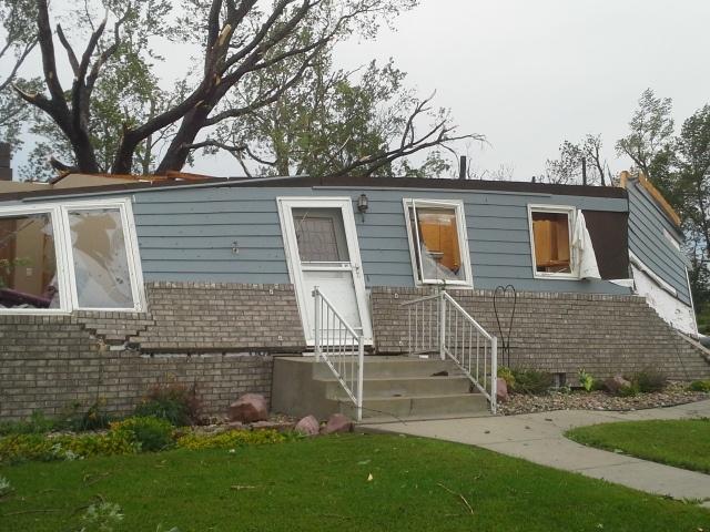
Destroyed home in Garretson. Resident is safe- she hid under the stairs #kelowx
The complex of storms from South Dakota to Wisconsin qualified as a derecho Monday morning after damaging wind reports spanned more than 400 kilometers, or about 250 miles.
"May through July is the peak for thunderstorm clusters with widespread damaging winds several hundreds of miles long, known as derechoes," said Erdman.
This is a breaking news story; please check back frequently for updates.


No comments:
Post a Comment