Published: June 10,2016
Tropical Storm Colin was the 144th consecutive tropical cyclone in the Atlantic Basin to not make landfall in the United States as a major hurricane, defined as a Category 3 or higher storm on the Saffir-Simpson scale, according to Colorado State University tropical meteorologist, Dr. Phil Klotzbach.
(MORE: The Record-Breaking 2005 Atlantic Hurricane Season)
 Tracks
of 66 Atlantic hurricanes, all of which have not made landfall in
Florida from Hurricane Beta (Oct. 2005) through Hurricane Alex (Jan.
2016).
Tracks
of 66 Atlantic hurricanes, all of which have not made landfall in
Florida from Hurricane Beta (Oct. 2005) through Hurricane Alex (Jan.
2016).The next longest streak was only five years, from 1901-1905 and again from 1910-1914.
Real Drought or Aribtrary Statistics?
The study concludes that caution must be taken when referring to a hurricane drought and its historical significance. This is because such droughts are dependent on the threshold used to define the drought.Increasing or decreasing one variable, such as sustained wind speed at the time of landfall, by as little as 5 mph can completely change the results of any hurricane drought. The same is true if minimum central pressure is used and increased or decreased by 5 millibars (mb).
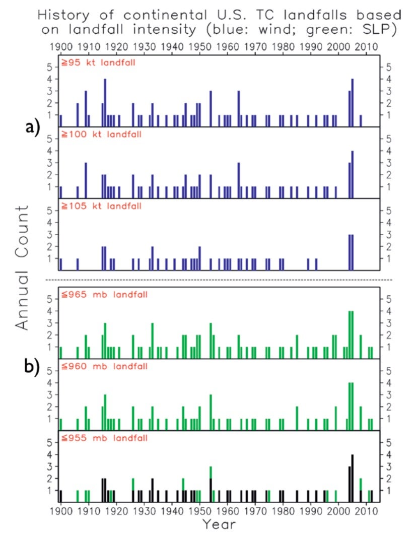 Fig.
2. (a) from the Dr. Hart et al. study shows the occurrence of U.S.
Atlantic coast (including Gulf of Mexico) tropical cyclone landfall as a
function of maximum sustained winds at landfall (kt). (b) is the same
as in (a), but uses minimum central pressure instead of maximum
sustained winds.
Fig.
2. (a) from the Dr. Hart et al. study shows the occurrence of U.S.
Atlantic coast (including Gulf of Mexico) tropical cyclone landfall as a
function of maximum sustained winds at landfall (kt). (b) is the same
as in (a), but uses minimum central pressure instead of maximum
sustained winds."Accordingly, we examined how the length of the drought changed by modifying the metric chosen: 105 vs. 110 vs. 115 mph landfall, or very low pressure landfall, or even coming close to the U.S. as a major hurricane but just missing U.S. landfall," Dr. Hart continues.
"In short, we found that when the metric for the landfall is slightly changed, the length or even existence of the drought changes dramatically. For example, when 110 mph is changed to 115 mph, the 1993-2003 period becomes a drought record that is even longer than the current one — yet no one apparently noticed because three 110 mph landfalls occurred during that 11-year 115 mph drought."
Dr. Hart concludes, "We must remember that while the peak wind intensity is the metric used officially and is tied to the Saffir-Simpson Wind Scale, there is considerable uncertainty to those wind estimates and that other measures of storm structure may more than occasionally better explain the human and property impacts."
 Fig.
5. from the Dr. Hart et al. study shows the occurrence of maximum
sustained winds ≥ 100 kt existing west of 70°W and north of 20°N in the
Atlantic. They chose this benchmark as the threshold for the analysis as
it is the approximate latitude of entry into the Gulf of Mexico and
longitude corresponding to Cape Cod, Mass.
Fig.
5. from the Dr. Hart et al. study shows the occurrence of maximum
sustained winds ≥ 100 kt existing west of 70°W and north of 20°N in the
Atlantic. They chose this benchmark as the threshold for the analysis as
it is the approximate latitude of entry into the Gulf of Mexico and
longitude corresponding to Cape Cod, Mass.In fact, two of the three costliest tropical cyclones in U.S. history have occurred during this supposed major hurricane drought, while two others were billion-dollar disasters.
Here are four examples of U.S. landfalls during this supposed major hurricane drought with impacts that were by any measure, major.
Hurricane Ike
Hurricane Ike made landfall as a Category 2 hurricane on Sept. 13, 2008, in Galveston, Texas. Sustained winds were 110 mph at landfall, not quite classifying the storm as a major hurricane.Ike sent a 10- to 15-foot storm surge into Galveston and parts of the western end of Galveston Bay, and up to a 20-foot surge over the Bolivar Peninsula and parts of Chambers County, Texas.
 Hurricane Ike visible satellite imagery on Sept. 12, 2008, at 12:05 p.m. CDT.
(NASA)
(MORE: Hurricane Ike Recap)
Hurricane Gustav
Hurricane Gustav made landfall as a Category 2 hurricane just two weeks before Ike on Sept. 1, 2008, near Cocodrie, Louisiana. Sustained winds were 105 mph at landfall, not high enough to be classified as a major hurricane.The hurricane was responsible for some of the worst wind damage to ever strike Baton Rouge, Louisiana. The city was shut down for over week during and after the storm due to the severe damage.
 Hurricane Gustav visible satellite imagery on Aug. 31, 2008, at 11:45 a.m. CDT.
(NASA)
Hurricane Irene
Hurricane Irene made its first U.S. landfall as a Category 1 hurricane on Aug. 27, 2011, near Cape Lookout, North Carolina. Sustained winds were 85 mph at landfall, but its unusually low pressure of 951 millibars (mb) was more typical of a Category 3 hurricane.Irene's second landfall was the next day, Aug. 28, 2011, in Brigantine, New Jersey. It was only a tropical storm with sustained winds of 69 mph during the second landfall.
Tropical Storm Irene then made a third landfall less than four hours later in Brooklyn, New York's, Coney Island neighborhood. This time, the sustained winds were down to 65 mph.
 Hurricane Irene visible satellite imagery on Aug. 28, 2011, at 8:32 a.m. EDT, just 28 minutes before landfall in Brooklyn.
(NASA)
Throughout Irene's path up the highly-populated East Coast, it caused widespread destruction and at least 56 deaths. Damage was estimated around $15.6 billion, making it the seventh-costliest hurricane in U.S. history.
Most of the damage was actually caused in the Northeast, where Irene was only a tropical storm.
(MORE: Hurricane Irene Recap)
Superstorm Sandy
Superstorm Sandy made landfall on Oct. 29, 2012, near Brigantine, New Jersey, the same place Irene did in 2011.Interestingly, Sandy was declared post-tropical less than three hours before landfall, although sustained winds were still around 80 mph when reaching the New Jersey coast. This is because the storm's convection had diminished as it accelerated toward the coast.
Sandy affected 24 states, including the entire Eastern Seaboard from Maine to Florida. It wasn't just a rain and wind storm, but it brought as much as two to three feet of snow to the mountains of Maryland and West Virginia, with lighter snows in Virginia, North Carolina, Tennessee, Kentucky and Ohio.
(MORE: Sandy's Snowy Side)
 Superstorm Sandy visible satellite imagery on Oct. 28, 2012, at 1:45 p.m. EDT.
(NASA)
Superstorm Sandy was responsible for $71.4 billion in damage, the second-costliest U.S. hurricane on record, even though it wasn't even a hurricane when striking the coast. Some parts of the Jersey Shore up through New York City and Long Island were completely destroyed. Additionally, 233 deaths were reported in the U.S. related to Sandy.
(MORE: Superstorm Sandy Recap)
Perhaps we should reconsider what makes a hurricane a "major hurricane" and base the criteria on impacts or other metrics, such as storm surge or the size of a hurricane's wind field, rather than an outdated 40-year-old scale based solely on wind speed.
(MORE: Does the Saffir-Simpon Scale Need an Improvement?)
No comments:
Post a Comment