Saturday, October 31, 2015

Flash Flood Threat Continues East Across the Deep South, Gulf Coast (FORECAST)

Linda Lam
Published: October 31,2015

Heavy rain that caused major flash flooding across much of Texas has been steadily progressing east across the Gulf Coast states. Flooding reached portions of southern Mississippi on Saturday and will gradually pivot east through Sunday. This latest wave of flooding is being enhanced by a moisture feed tied to the remnants of Hurricane Patricia.
As much as 13 inches of rain in upper coastal Texas spawned major flash flooding across Houston, Texas, and nearby communities Saturday. Flash floods with torrential rain in central Texas have killed at least four people since Friday, and closed countless roads and flooded homes.
(MORE: Flash Flooding, Tornadoes Reported)

Latest Radar, Flooding, Severe Alerts
A flash flood emergency was issued Saturday for parts of three east Texas counties - Tyler, Hardin and Jasper Counties - where water rescues and road closures were numerous.
The National Weather Service issued flash flood warnings for parts of Louisiana and southern Mississippi Saturday.
Flood watches continue from parts of Louisiana into southern Alabama. 
(INTERACTIVE: Flood Alerts)

Flood Alerts


Gulf Moisture Feeds Heavy Rain Threat

As jet stream energy slips through the southern Plains and toward the lower Mississippi Valley, a plume of moisture from the Gulf continues to surge north.
Low pressure advancing across the Gulf Coast states will be accompanied by the threat for heavy rain over much of the Southeast through Monday.
The storm system will not exit the East Coast until early next week, although the intensity of the rain will tend to become less extreme with time.
Still, widespread rainfall totals of 1 to 3 inches are expected from the central Gulf Coast to parts of the Carolinas and Virginia, with locally higher amounts.

Rainfall Forecast
Aside from the heavy rain and flash flooding threats, the risk for severe thunderstorms will continue, thanks in part to some modest instability and favorable low level wind fields.
The focus for any severe thunderstorms is mainly along and near the Gulf Coast through Sunday.

Heavy Rain Threat Setup This Weekend


(MORE: Severe T-Storm Forecast)

Timing of the Rain

A broad area of rain across the Deep South will progress east, eventually reaching the Carolinas and lower Middle Atlantic region by Monday. The focus for the heaviest rainfall will be where bands and clusters of thunderstorms develop, locally enhancing rainfall rates.
Sunday: Early in the day, heavy rainfall will persist across much of Louisiana and parts of Mississippi with some of that heavy rain likely moving through northwestern Georgia as well. Further south and east, thunderstorms over southern Alabama and the western Florida panhandle may also pose a threat of gusty winds and flash flooding.
Later in the day, a second round of thunderstorms will target southern Mississippi, southern Alabama, the Florida panhandle and perhaps southwestern Georgia. Here, a few isolated severe thunderstorms cannot be ruled out.

Sunday's Forecast
Monday: Locally heavy rain will spread from the southern Appalachians into parts of the Carolinas and as far north as central Virginia. Scattered showers and a few thunderstorms remain possible further south across Georgia and northern Florida.
Rain should be tapering off over Alabama into the Tennessee Valley with the bulk of the precipitation exiting the East Coast late Monday night.

Monday's Forecast

Additional Flooding and Rainfall Reports

The final estimated daily rainfall total on Friday for Austin Bergstrom International Airport was 14.99 inches, according to the San Antonio National Weather Service office. The total had to be estimated because the Automated Surface Observing System (ASOS) equipment that normally records weather data at the airport malfunctioned after 5.76 inches of rain fell in a single hour, an amount exceed by only six prior 24-hour calendar days in the site's history.
This narrowly missed tying the wettest calendar day in the city's history, 15.00 inches on September 9, 1921. This one-day total was greater than the five-month average precipitation from August through December (14.23 inches).
At one point, an hourly rain rate of 7 inches was measured by the nearby Lower Colorado River Authority (LCRA) gauge along Onion Creek at U.S. 183, used to calculate a provisional total until the NWS can determine whether all the day's data can be salvaged from the airport's hobbled ASOS. That gauge recorded 13.40 inches of rain in just 3 hours Friday morning.
That's wetter than any previous 15-day period on record for the airport site since records began in 1942. Combined with rains from the Oct. 22-25 storm, ABIA picked up more than 22 inches of rainfall in just nine days.
Onion Creek subsequently climbed to a crest of 39.12 feet, which is more than 22 feet above flood stage and second only to its all-time crest of 40.2 feet set almost exactly two years ago. Records at the gauge date back at least 146 years.
Upstream, Onion Creek shattered its previous record crest at Driftwood of 25.1 feet during the devastating flash floods of Oct. 17, 1998.
In Houston, both Hobby and Intercontinental airports set daily rainfall records on Saturday with each site picking up more than 5 inches of rain for the day.

Selected Rainfall Totals
Other flood reports from Friday and Saturday included:
  • Houston: Numerous reports of high water, rescues particularly in south metro Saturday morning. Over 13 inches of rain in parts of Harris County. Forty homes flooded in east side near I-10 and Beltway 8.
  • Liberty, Texas: Six homes flooded, numerous roads closed
  • Corsicana, Texas: Interstate 45 was shut down in both directions in Navarro County overnight Friday night, but was reopened Saturday morning.
  • Lake Mexia, Texas: Lake levels rose to 4 feet above normal pool, prompting evacuations of some residents near the lake.
  • Dallas-Ft. Worth metro: At least one water rescue in downtown Dallas; street closures in Rowlett.
  • Bastrop, Texas: Evacuations along the Colorado River Saturday; homes flooded.
  • Brownsville: Water entering a home near Brownsville-S. Padre International Airport; 4.71 inches of rain in roughly 1 hour and 45 minutes through 12:39 p.m. CDT.
  • Comal County: Evacuations along Guadalupe and Comal Rivers
  • San Marcos: The Blanco River rose 34 feet from Friday morning to the afternoon, cresting just under one-half a foot lower than its destructive Memorial Day flood crest.
  • Wimberley: Flooding along Cypress Creek prompted evacuations the site of severe flooding in May. Rapidly-moving water was reported over the State Highway 12 bridge there. The Blanco River crested just over 13.5 feet above flood stage just before midday Friday, nearly matching the Halloween 2013 crest, but over 18 feet lower than the historic May flood event.

Unusually Strong Cyclone Chapala Eyes Oman, Yemen

By Eric Leister, Meteorologist
October 31,2015; 9:24PM,EDT
 
 
Yemen and Oman are bracing for impacts from a small, but currently powerful Tropical Cyclone Chapala (04A) in the Arabian Sea.
Tropical Cyclone Chapala (04A) became the equivalent to that of a Category 4 hurricane in the Atlantic or eastern Pacific Ocean on Friday, local time.
Image of Tropical Cyclone Chapala taken on Sat. Oct. 31, 2015. (NOAA/Satellite)
"Chapala became the second strongest cyclone on record in the Arabian Sea," AccuWeather Senior Meteorologist Jason Nicholls said. "The pressure of Chapala is 922 mb, close to the lowest pressure of Gonu, 920 mb, in 2007."
Nicholls added that the last cyclone to strike Yemen was Keila in 2011 and was only equivalent to a weak tropical storm.
Chapala is forecast to weaken substantially, prior to making landfall early late Monday or early Tuesday, local time.
This tropical system will have no direct impacts on India as steering winds from the east will result in a track toward Africa and the Arabian Peninsula.

"The main threat area from Chapala will be Yemen and Oman," Nicholls said of the tropical system in the Arabian Sea.
Nicholls anticipates, "Several inches of rain and flooding are possible, starting on Sunday as the cyclone approaches but remains offshore."
The latest forecast continues to take Chapala westward before turning northwest as it approaches the coast of eastern Yemen on Monday. This scenario would bring little or no impacts to western Yemen and northeast Somalia.
RELATED:
Oman Weather Center
Indian Ocean Tropical Cyclone Center
Yemen Weather Center

Seas will build substantially in advance of Chapala along the coast of Somalia, Yemen and Oman. Offshore waves within 160 km (100 miles) of the center will range between 4 and 8 meters (15 and 25 feet).
Chapala will weaken as it approaches the Yemen coastline.
According to AccuWeather Senior Meteorologist Alex Sosnowski, exactly how quickly the system will weaken is uncertain at this time.
"A strike on the Arabian coast by a major tropical cyclone is rare due to great amount of dry air that is drawn in from the Arabian Peninsula well ahead of the storm," Sosnowski said.
Chapala could still be a dangerous cyclone equivalent of a Category 1 or 2 hurricane as it makes landfall in eastern Yemen.

Eastern Yemen and far southwest Oman should be on highest alert for this storm that is expected to bring flooding and damaging winds.
Areas within 50 km (30 miles) of landfall will see the worst conditions with damaging winds, coastal flooding and torrential downpours.
Locations in Yemen that may be impacted by the damaging hurricane-force winds of Chapala include Sayhut, Itab, Qishn, Haswayn, Nishtun and Al Ghaydah.
Rainfall will average 100-200 mm (4-8 inches) across far eastern Yemen and parts of Oman near the border producing life-threatening flooding.
AccuWeather meteorologists will continue to monitor the Indian Basin, following this pattern change, in the coming weeks.
AccuWeather Meteorologist Adam Douty contributed content to this story.
 

Rain to Hold Off for World Series Game 4 in NYC

By Chyna Glenn, AccuWeather.com Meteorologist
October 31,2015; 9:15PM,EDT
 
 
Game 4 has the Mets facing off against the Royals at Citi Field in Flushing Meadows, New York, and the weather will cooperate.
The outcome of World Series Game 3 had the Royals leading the series 2-1.
Since the New York Mets came out victorious against the Kansas City Royals, Game 4 will not be the deciding factor on which team will take home the coveted Commissioner's Trophy this year.

Saturday will bring several hours of sunshine and temperatures peaking in the upper 50s, which is typical of the last week in October.
By the start of the game, temperatures will have fallen back into the into the lower 50s, with thickening clouds.
Although it will be cloudy, conditions will remain dry and cool for the entirety of the game.
Winds will not have an impact on game play either, according to Senior AccuWeather Meteorologist Dan Pydynowski.
RELATED:
El Nino to Shape November Weather in US: East to Warm as Chill Blasts West
US Winter Forecast: Northeast to Dodge Winter's Brutal Cold; Rain, Snow to Dent California Drought
Halloween Forecast: Rain to Dampen Trick-or-Treaters in More Than a Dozen StatesHalloween Forecast: Rain to Dampen Trick-or-Treaters in More Than a Dozen States

"The wind will be rather light this evening and should not have a huge impact for Game 4. They will be from the south to southwest and under 10 mph, which will have them blowing out to center or right-center field," Pydynowski said.
Those heading out to the game will want to bring a jacket or blanket as the air will be chilly with temperatures in the lower 50s through the last pitch.
Since Game 4 will not be the deciding factor for the winner of the World Series, Game 5 will also take place in Citi Field on the 1st of November.
Following the possibility of a stray shower on Sunday morning for the New York Marathon, Game 5 is looking to be the milder of the two remaining games in New York. Temperatures by the first pitch on Sunday are expected to be closer to the 60-degree mark, which will be nearly 10 degrees warmer than the start of Game 4 the previous day.
 

National Temperature and Rainfall Extremes for October 31,2015 from accuweather.com

As of 11PM,EDT/8PM,PDT


Daily U.S. Extremes

past 24 hours

  Extreme Location
High 95° San Luis Obispo, CA
Low 15° Hysham, MT
Precip 6.67" Fort Polk, LA

This Date in Weather History for October 31,2015 from weatherforyou.com

Weather History
For Saturday,October 31,2015


1846 - Eighty-seven pioneers were trapped by early snows in the Sierra Nevada Mountains that piled five feet deep, with 30 to 40 foot drifts. Just 47 persons survived the "Donner Pass Tragedy". (The Weather Channel)
1950 - Unseasonably warm weather prevailed in the central U.S. for Halloween. The temperature soared to 83 degrees at Minneapolis MN, their warmest reading of record for so late in the season. (The Weather Channel)
1965 - Fort Lauderdale, FL, was deluged with 13.81 inches of rain, which brought their rainfall total for the month of October to an all-time record of 42.43 inches. (30th-31st) (David Ludlum) (The Weather Channel)
1987 - Halloween was a wet one in the southwestern U.S. Heavy rain in southern California resulted in numerous mudslides. Weather-related auto accidents resulted in three deaths and twenty-five injuries. Mount Wilson CA received 3.14 inches of rain in 24 hours. Yakima WA reported measurable rainfall for the first time since the 18th of July. The 103 day long dry spell was their longest of record. (The National Weather Summary) (Storm Data)
1988 - Twenty-two cities in the northeastern U.S. reported record low temperatures for the date. The low of 19 degrees at Cleveland OH was a record for October, and morning lows of 21 degrees at Allentown PA and Bridgeport CT tied October records. Nine cities in the southwestern U.S. reported record high temperatures for the date, including Phoenix AZ with a reading of 96 degrees. Showers made Halloween a soggy one in the southeastern U.S. (The National Weather Summary)
1989 - Halloween night was a soggy one in New England. Showers in the northeastern U.S. produced more than an inch and a half of rain in six hours at some locations. An invasion of cold arctic air brought an abrupt end to a week of "Indian Summer" type weather in the Great Lakes Region, and brought snow and subzero wind chill readings to the Northern Plains. In Colorado, Alamosa was the cold spot in the nation with a record low of two degrees above zero, and a Halloween night storm brought 3 to 6 inches of snow to the Front Range, and 5 to 10 inches to the nearby foothills. Icy streets around Denver the next morning made for a rather spooky commute. (The National Weather Summary) (Storm Data)

Friday, October 30, 2015

Two Dead as Severe Flooding Swamps South-Central Texas; Multiple Tornadoes Reported

Sean Breslin
Published: October 30,2015

Two people are now dead after an onslaught of torrential rain caused a nightmare flooding event in South-Central Texas Friday.
Roger Wade, Travis County public information officer, said a man in his 40s or 50s was found on the 10300 block of FM 1625 around 4 p.m. local time after he was swept away by floodwaters in Travis County, Texas.
Eyewitnesses told authorities they were attempting to reach the man on the roof of his car when he was swept away, KVUE reports. The man has not been identified, pending notification of relatives.
The second death was confirmed Friday night after the victim's body washed up in Camp Bullis, a U.S. Army training camp, around 6:15 a.m. 502nd Air Base Wing chief of public affairs for Joint Base San Antonio Oscar Balladares said the individual was a contract exmployee whose vehicle was washed down stream. An identity has yet to be released.
(MORE: Track Severe Weather in the South)
According to KVUE, crews are also looking for a 37-year-old man who was swept off the top of his car in the area of SH 130 and FM 812. Two other people were in the car, but they were rescued.
An elderly woman went missing near Citation and Ruidosa in Southeast Travis County around 1:15 p.m. Friday. The woman and her husband were being rescued from a home at the time. Crews were able to get her husband to safety. He was taken to an area hospital.

South-Central Texas: Homes, Roads Collapse; State of Disaster Declared 

The Sheriff’s Office was working a house collapse and gas leak at 10600 Ruidosa early Friday evening. The Austin Fire Department also responded to the location.
Later Friday, a state of disaster was declared for the county, the Austin Statesman reported.
A separate flood emergency was issued in South Austin, in areas near Onion Creek in Travis County. For those looking for a place to take shelter in the Onion Creek area, Dittmar Recreation Center was made available.
Near Driftwood, Onion Creek quickly rose to a new record level. Before noon Friday, water levels at that part of the creek were already above the previous record of 25.1 feet, and the waterway was expected to continue its rise.
Multiple water rescues were conducted elsewhere in Austin and Travis counties, including the rescue of two police officers caught in rushing floodwaters, as well as that of Ed Asapi, who clung to an 18-wheeler until rescuers reached him.
"We just thought like this is it. That's the end of our journey today. But then they got us, they got through," Asapi told KVUE.
More than 10 inches of rain fell in a two-hour span near the creek Friday morning. Multiple people were rescued from floodwaters in Travis County earlier Friday morning.
The Austin County Emergency Management Service reported Friday afternoon that multiple residents in the Man-O-War/Maha Loop/Quicksilver area were stranded on their rooftops and rescues were underway. Austin ResQ Medics escorted a medical patient across a flooded roadway to a waiting ambulance and made at least one water rescue later Friday.
(MORE: The 9 Worst Things You Can Do During A Flood Emergency)
Among those rescued earlier in the day was a church group from Dallas, stuck at a Wimberley bed-and-breakfast when a nearby creek overflowed and trapped them. Kathleen Haney told the Associated Press she and seven others from the Dallas group were saved by members of the National Guard when they strung a rope between the staircase and higher ground, and they were then brought to safety.
The flooding was so strong that it swept away three of their cars and snapped several trees, she told the AP.
Heavy rains undercut a road outside Elgin, Texas Friday afternoon causing it to collapse.
(Twitter/Sakeenah)
Heavy rains in Elgin undercut Ann Flowers Drive causing a section of the road to collapse Friday afternoon.Flooding forced San Marcos city officials to close an evacuation center at the San Marcos Activity Center Friday afternoon. Citizens who were waiting out the flood at the Activity Center were bussed to a new evacuation center at Miller Middle School.
In Austin, boats were deployed by the Austin Fire Department to help with water rescues. Passenger vehicles were nearly submerged by floodwaters near the interchange linking U.S. Highway 183 and State Route 71 near Austin-Bergstrom International Airport late Friday morning.
Many of the small creeks that run through the city of Austin were raging torrents Friday morning, with some near or above flood stage.
Areas near the Blanco River were also being evacuated Friday morning, and the bridge over the river at RR 12 in Wimberley was closed.
In eastern Bexar County, a school bus with children inside got stuck in high water, and crews were able to successfully remove everyone inside, the Bexar County Sheriff's Office said via Twitter.
New Braunfels officials warned residents to take flooding seriously and get to safety. A civil emergency message was issued for Comal County, warning residents that river flooding along the Comal and Guadalupe rivers was imminent, and residents in low-lying areas should evacuate to Canyon High School.

Lightning Strike in Brownsville

The National Weather Service office in Brownsville took a direct lightning strike on it's radar assembly Friday evening as storms continued to roll through the area.
(WATCH: Lightning Strikes Radar Assembly)
More than a half-foot of rainfall has been observed in parts of Brownsville on Friday, creating widespread travel problems. Several streets were closed, according to the Brownsville Herald, and power outages also knocked out many traffic lights in the city.
Hundreds of homes in Brownsville lost power during the storms, and thousands more were in the dark in the suburbs, the report added. All Halloween events scheduled Friday night by the Brownsville Police Department have been canceled, the Herald also said.
NWS Brownsville reported that high winds blew the windows out of several cars and tore the roof of a mobile home several miles north of Willamar, Texas, Friday morning.

Reported Tornadoes Leave Damage

The towns of D'Hanis and Floresville took the hardest hit from the early Friday suspected tornadoes. There were also reports of damage near San Marcos as the severe weather pushed northeast. Bluebonnet Electric tweeted photos of a mangled transmission tower near San Marcos Friday afternoon.
A transmission line at Center Point Road in San Marcos was mangled by the . (Photo by John Riley)

NWS meteorologist Jason Runyen said businesses have been damaged in downtown D'Hanis and that trees are also down. Medina County authorities told NBC San Antonio that a bank was destroyed and other buildings were damaged, but they were unsure if there were any injuries.
The Wilson County Sheriff's Office told The Weather Channel that Floresville High School was damaged. No injuries have been reported from either of the suspected tornadoes.
When the suspected tornado hit Floresville at about 6 a.m. local time, Ruth Veliz was at her parents' taco shop with about a dozen customers and employees. She told the AP an employee exclaimed "Tornado!" and attempted to close the door as strong winds bore down on the building.
Those inside the shop took cover anywhere they could and rode out the storm. "We were all caught off guard, everyone just grabbed on to what they could get their hands on," Veliz told the AP.
Floresville ISD said on its Facebook page that schools will be closed Friday.
Floresville HS after the tornado this morning. Not far from my house.

Downtown D'Hanis!

Some homes and other structures between Seguin and Zorn lost roofs during the storms, Guadalupe County Sheriff's Capt. Tom Meeley told the Associated Press.
D'Hanis is located some 50 miles west of San Antonio, while Floresville is about 30 miles southeast of the San Antonio. The two cities are about 70 miles apart.

More Storms on the Way

Severe weather is expected to continue in the Southern Plains throughout the weekend.
"The threats are two-fold. First, warm and very humid air coupled with an approaching southward dip in the jet stream will spawn severe thunderstorms, some of which may spawn tornadoes, in Texas and the Deep South through Saturday," said weather.com meteorologist Jon Erdman. "Secondly, areas of slow-moving, heavy rain will trigger flash flooding in Texas and Oklahoma through early Saturday, then spread into the Lower Mississippi Valley and Deep South later Saturday. This flood threat includes San Antonio, Austin, Dallas and Houston."
This is a developing story. Please check back frequently for updates.

Cyclone Chapala Remains a Powerful Storm in the Arabian Sea; Rare Destructive Landfall Threat to Yemen, Oman

Jon Erdman
Published: October 30,2015

Cyclone Chapala became the strongest tropical system so far south in the Arabian Sea on record and may make an unprecedented landfall at hurricane strength along the coast of Yemen or southwest Oman in the days ahead.
Chapala rapidly intensified and had estimated winds as strong as a high-end Category 4 early Friday. Some further decrease in intensity are expected over the next day or so as the system gradually weakens.

Cyclone Chapala: Current Status
While direct measurements from reconnaissance aircraft are not available over the Arabian Sea, Chapala's rate of intensification from a high-end tropical storm to a high-end Category 4 storm in 24 hours ending 2 a.m. EDT Friday morning was quite impressive for this part of the world.
Tropical cyclones in the Indian Ocean basin, which includes the Arabian Sea, are simply known in English as "cyclones" or "cyclonic storms" regardless of strength. There are no special terms such as "hurricane" or "typhoon" applied based on reaching a certain intensity, but the India Meteorological Department does apply various adjectives such as "severe" or "very severe" to describe different intensity levels.
(MORE: Why Tropical Cyclones Are Named)
Warmer-than-average Arabian Sea water along its path had, in part, allowed for Chapala is intensify so rapidly.
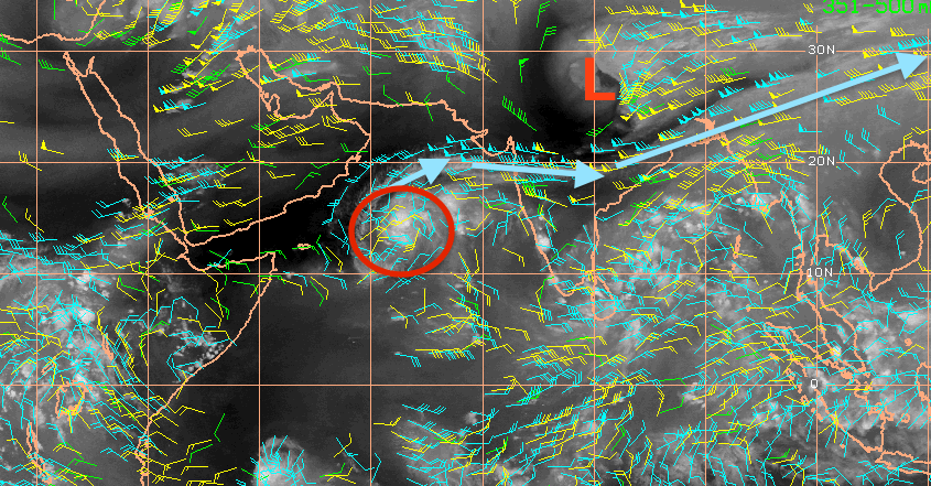
Impressive outflow channel N of Cyclone . Shows the fine line between being sheared apart & possible RI.

Steered by subtropical high pressure, Chapala is expected to track west or west-northwest through the weekend, making landfall along the coast of eastern Yemen or southwest Oman Monday.

Cyclone Chapala's Forecast Path
Tropical cyclones that do near the Arabian Peninsula often ingest dry, desert air and weaken before making landfall, if they do at all.
In this case, we expect Chapala to make landfall as a weaker, possibly much weaker cyclone than its potential maximum intensity over the Arabian Sea. Small tropical cyclones can both intensify rapidly and weaken rapidly.
However, Chapala may still be a formidable cyclone of at least Category 1 intensity at landfall, a very unusual, if not unprecedented occurrence for Yemen or southwest Oman. (More on that below.)
The threat of heavy rainfall should be in play regardless of the intensity.
Chapala has the potential to dump 3-4 times or more the average yearly rain in just a day or two over parts of eastern Yemen and southwest Oman. According to worldclimate.com, the average annual rainfall in Salalah, Oman (estimated population 197,000 as of 2009), is only around 4 inches.

Model Rainfall Forecast: Cyclone Chapala
Mountains surround the coastal city of Salalah, Oman, and also are situated to the north of several eastern Yemeni coastal cities.
(INTERACTIVE: Oman/Yemen Coast in the Path of Chapala)
Rivers running from these mountains that are normally dry or feature very low flow would see rapid rises with rainfall of this magnitude, which could be destructive or deadly.

Unprecedented Landfall?

You may wonder how often "tropical cyclone" and the "Arabian Peninsula" appear in the same sentence. How unusual could Chapala be?
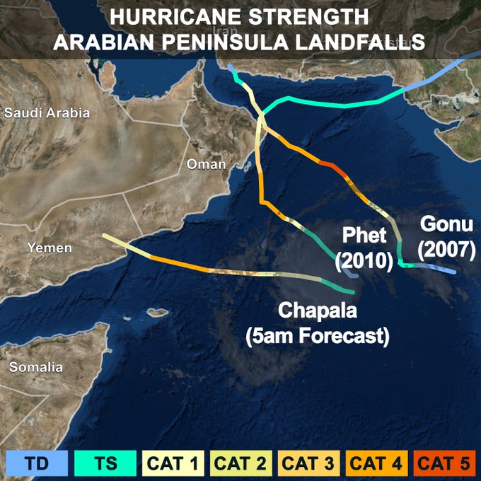
First, according to hurricane specialist Michael Lowry and the NOAA best track database, there is no record of a hurricane-strength cyclone landfall in Yemen dating to 1945.
forecast to hit Arabian Peninsula as only 3rd hurricane strength landfall on record. Big rains to dry area.

Weather Underground's Dr. Jeff Masters says Tropical Depression Three in 2008 claimed 90 lives and was responsible for $400 million in damage.
(WUNDERBLOG: Cyclone Chapala's Yemen Threat)
Secondly, there has been only one Category 5 equivalent Arabian Sea cyclone of record, Gonu in 2007, which weakened before making landfall in northern Oman near the capital, Muscat. Weather Underground's Dr. Jeff Masters notes, however, that reliable satellite estimates in the Arabian Sea date only to 1990.
There is no record of a cyclone of Category 4 strength or stronger tracking as far south as Chapala in the Arabian Sea.
(MORE: Hurricanes in Strange Places
Despite all this, Arabian Sea tropical cyclones are not as unusual as they sound.
Each year, an average of one to two tropical cyclones form in the Arabian Sea, according to a 2011 climatology study by Amato Evan and Suzana Camargo.
Tracks of all recorded global tropical cyclones from 1851-2008. Tracks in the Arabian Sea are highlighted by the yellow box. (NOAA/NCDC)


These cyclones are most likely to form in two periods: from May through June and October through November. The mid-late summer period is typically not favorable, thanks to increased wind shear from the wet phase of the Asian monsoon.
(MORE: Where the Season Peaks Twice)
In June 2007, Cyclone Gonu was the most intense Arabian Sea storm on record, making landfall in Oman, then in southern Iran.
Gonu claimed 100 lives in Oman, Iran and the United Arab Emirates and was responsible for $4 billion in damage, according to the Evan and Camargo study.
Almost exactly three years later, Cyclone Phet alarmingly intensified to a Category 4 equivalent cyclone, before weakening to a Category 1 storm upon making landfall on the eastern tip of Oman, east of the capital city of Muscat.
In May 1999, Cyclone ARB 01 slammed into Pakistan near Karachi as a strong Category 3 equivalent storm, killing at least 700 in Pakistan. This was the strongest tropical cyclone on record to hit Pakistan.
(MORE: Deadliest Tropical Cyclones in World History)
In the limited historical record, however, strong cyclones in the Arabian Sea are more rare than other basins, due to the proximity of dry air from the Arabian Desert, the aforementioned increased wind shear during the wet phase of the Asian monsoon, and the basin's overall small size.

MORE: Cyclone Gonu - June 2007


Inches of Rain, High Winds to Whip Across Northwest US Through Sunday

By Brett Rathbun, AccuWeather.com Meteorologist
October 30,2015; 10:35PM,EDT
 
 
A powerful storm system will bring heavy rain and strong winds across the northwestern United States through the weekend.
"A potent storm laden with Pacific moisture will move into the Pacific Northwest on Friday and continue through the weekend," AccuWeather Meteorologist Dan Pydynowski said.
"The parade of storms will bring a flood threat through this weekend across much of western Washington, especially in the foothills and Cascade Mountains," he said.
Wet Conditions Return to Texas
Rain will be the heaviest across western Washington and northwestern Oregon and will impact the cities of Seattle and Portland, Oregon. Rain will also be heavy across southwest British Columbia, impacting Vancouver.
Multiple inches of rain may fall in some areas over the course of the storm.
"Rain amounts in excess of 8 inches are possible through the weekend and could lead to flooding, mudslides and a sharp rise on area rivers across the Washington Cascades," Pydynowski said.
Rain, along with falling leaves, could produce slick spots on roadways.

While the rain is needed across the Northwest, this stretch of heavy rain may ruin Halloween plans through the weekend.
Those traveling on Interstates 5 and 90 will need to use their windshield wipers at full force through this weekend and should stay alert for blinding downpours and ponding on roadways.
Drivers should slow down through any wet roadway to reduce the risk for hydroplaning.
Use AccuWeather Minutecast® for the minute-by-minute precipitation forecast for your area. Mobile users can also use their GPS location.
As this storm system slowly filters in cooler air, snow levels will decline through the weekend.
"Snow levels will be around 8,000 feet through Saturday before dropping closer to 4,500 feet on Sunday," Pydynowski said.
Rain will not be the only impact across the Northwest through the weekend. Strong winds will whip across the region through Sunday, producing dangerous travel conditions.

Winds could occasionally gust up to 50 mph from Seattle to Portland and Pendleton, Oregon, and Billings, Montana.
Winds could gust up to 60 mph along the Washington coast, the Cascade Mountains across Washington and Oregon and across the Rocky Mountains of Idaho and western Montana. Winds in the Lewis Range in western Montana could gust up to 80 mph.
Heavy rain combined with strong winds could lead to uprooted trees and the risk of sporadic power outages.
The wind and rain could lead to tough conditions for college football in Washington Saturday night. Washington State hosts No. 8 Stanford while the Washington Huskies welcome the Arizona Wildcats to Seattle.
RELATED:
Northwest Regional Radar
Current US Watches and Warnings
PHOTOS: Rare Flower Bloom Makes One of World's Driest Deserts Come to Life

This rain will fall over the regions of the Northwest thirsty for any rainfall according to the U.S. Drought Monitor.
A parade of storms may bring much needed rain into the Northwest into the beginning of November, AccuWeather Meteorologist Ed Vallee said.
"The upcoming weather pattern through the first part of November favors additional storminess across the Northwest. As the month progresses, some rain may shift southward into Northern California."
This continuous pattern of storm systems across the Northwest may be short-lived heading into the winter season.
The AccuWeather Winter Forecast suggests that the storm track along the West coast will be more from California into the southern Plains, causing below-normal precipitation, in the form of both rain and snow, across the Northwest.
While there will still be storm systems bringing rain and snow to the Northwest, the activity is expected to be less frequent as other winters.
The dryness expected across the Northwest could eventually translate to building drought conditions if spring rain is not abundant.

Unusually Strong Cyclone Chapala Eyes Oman, Yemen

By Eric Leister, Meteorologist
October 30,2015; 10:31PM,EDT
 
 
Yemen and Oman are bracing for impacts from strengthening Tropical Cyclone Chapala (04A) in the Arabian Sea.
Tropical Cyclone Chapala (04A) currently has sustained winds equal to that of a Category 4 hurricane in the Atlantic or eastern Pacific Ocean.
Chapala is forecast to strengthen further with winds equal to that of a Category 5 hurricane by later Friday or Saturday and already ranks as one of the strongest tropical cyclones on record in the Northern Indian Ocean.
"Chapala could also become the strongest cyclone on record in the Arabian Sea," Accuweather Senior Meteorologist Jason Nicholls added. "The pressure of Chapala is 922 mb, close to the lowest pressure of Gonu, 920 mb, in 2007."
This tropical system will have no direct impacts on India as steering winds from the east will result in a track toward Africa and the Arabian Peninsula.

"The main threat area from Chapala will be Yemen and Oman," Nicholls said of the tropical system in the Arabian Sea.
Nicholls anticipates "Several inches of rain and flooding are possible, starting on Sunday as the cyclone approaches by remains offshore"
The latest forecast continues to take Chapala westward before turning northwest as it approaches the coast of eastern Yemen on Monday. This scenario would bring little or no impacts to western Yemen and northeast Somalia.
RELATED:
Oman Weather Center
Indian Ocean Tropical Cyclone Center
Yemen Weather Center

Chapala will weaken as it approaches the Yemen coastline as drier air from the Arabian Peninsula begins to interact with the cyclone.
Despite weakening, Chapala will still be a dangerous cyclone equivalent of a Category 1 or 2 hurricane as it makes landfall in eastern Yemen.

Eastern Yemen and far southwest Oman should be on highest alert for this storm that is expected to bring flooding rain and damaging winds.
Areas within 30 miles of landfall will see the worst conditions with hurricane-force winds and torrential downpours.
Locations in Yemen that may be impacted by the damaging hurricane-force winds of Chapala include Sayhut, Itab, Qishn, Haswayn, Nishtun and Al Ghaydah.
Rainfall will average 100-200 mm (4-8 inches) across far eastern Yemen and parts of Oman near the border producing life-threatening flooding.
AccuWeather meteorologists will continue to monitor the Indian Basin, following this pattern change, in the coming weeks.
 

PHOTOS: Possible Tornado Tears Through Floresville, Texas

By Katy Galimberti, AccuWeather.com Staff Writer
October 30,2015; 10:27PM,EDT
 
 
Residents from San Antonio to Austin, Texas, woke to severe storms capable of producing tornadoes on Friday morning.
A possible tornado was reported in Floresville, Texas, outside of San Antonio on Friday morning. The local high school sustained damage and classes were canceled.
In Hays County, Texas, located near Austin, local emergency management confirmed damage to a wood-frame house, indicative of a tornado at 6:44 a.m. CDT.
Flying debris injured one person in Willacy County, Texas, near Brownsville. Emergency management reported that windows were blown out of several cars. A roof of a mobile home was also torn off, according to the NWS report.
Several structures in Floresville, Texas, sustained damage on Friday. (Twitter Photo/@wiley_coyote98)
"A vigorous storm system moved into Texas Friday morning and sparked strong thunderstorms along the Interstate 35 corridor from the San Antonio area into Austin," AccuWeather Meteorologist Andy Mussoline said.
"Strong, twisting winds in the atmosphere combined with abundant moisture in the region to create thunderstorms capable of producing tornadoes. In addition to the isolated tornado threat, the storms also prompted flash flooding in the area due to the abundant moisture," he said.
In addition to the potential tornadic activity, another round of flooding rain invaded the region. Hays County residents in the Wimberly area near Cypress Creek were told to evacuate Friday morning, and multiple roadways were closed due to flooding from San Antonio to Austin.
As of 10:50 a.m. Friday, 16 inches of rain was recorded in Kyle, Texas, since the start of the storm.
The Austin-American Statesman reports one person is dead and another two missing in Travis County as a result of the severe flooding.
The threat for flooding will persist into the weekend as heavy rain is expected to fall across Eastern Texas.
A declaration of disaster was declared for Bastrop County due to the severe weather, the Bastrop County Sheriff's Office said.
Possible Tornado Touches Down in Floresville, Texas
RELATED:
Soaking Rain to Renew Flood Threat From Dallas to Houston This Weekend
Eastern Texas Weather Radar
AccuWeather Severe Weather Center

A high school in Floresville, Texas, was damaged on Friday morning, Oct. 30. (Twitter Photo/@breea1997)
A possible tornado caused damage to Floresville High School outside of San Antonio, Texas, on Oct. 30. (Twitter Photo/@breea1997)
A possible tornado swept through Floresville, Texas, on Friday, Oct. 30. (Twitter Photo/@wiley_coyote98)
Severe storms hit the Floresville, area, on Oct. 30. (Twitter Photo/@wiley_coyote98)
An apartment complex parking lot was flooded in San Marcos, Texas, on Friday, Oct. 30. (Twitter Photo/Aaron M. Orozco)
In Bexar County, Texas, six people were rescued from a flooded bus on Friday morning. (Twitter Photo/Bexar County Sheriff)
Water rescues were underway in Bastrop County, Texas, Friday evening. (Photo/Bastrop County Sheriff's Office)
 

Weekly Wrap-Up: Serious Flooding Swamps Texas; Mexico Escapes Major Loss of Life From Powerful Patricia

By Kevin Byrne, AccuWeather.com Staff Writer
October 30,2015; 10:25PM,EDT
 
 
See larger image below.
Heavy rains brought severe flooding to Texas last weekend, wreaking havoc across the roadways and causing thousands to lose power.
Between Friday, Oct. 23, and Sunday, Oct. 25, 21.67 inches of rain fall in Corsicana, Texas, which is located about 55 miles south of Dallas. Nearly 30 water rescues had to be performed in the Houston area as the floodwaters submerged roadways.
Between 8 and 9 inches of rain fell across Baton Rouge and New Orleans, Louisiana, on Sunday. One woman was injured due to damage to her mobile home after a tornado touched down in Destrehan, Louisiana, Sunday morning.
TRENDING: Grizzly Charges Alaska Fishermen; News Anchor Runs Off Set Amid Earthquake
While the flooding in Texas impacted travel and property, it also helped alleviate drought conditions.
Last week about 21 percent of the state was dealing with extreme drought according to the U.S. Drought Monitor. However, as of Oct. 27, the state has no locations facing extreme or exceptional drought and only 2.85 percent of the state is facing severe drought, compared to 41.88 percent last week.
A driver attempts to navigate through high water on Northwest Highway during a heavy rain fall Friday, Oct. 23, 2015, in Dallas. (AP Photo/Tony Gutierrez)
Meanwhile, Patricia became the strongest hurricane on record on Friday, Oct. 23, with an estimated central pressure of 879 mb, breaking the record of 894 mb from Hurricane Linda in the eastern Pacific set in 1997.
The storm grew into a massive Category 5 storm off the southwest coast of Mexico and made landfall at approximately 6:15 p.m. CDT on Friday, Oct. 23, near Cuixmala, Mexico, which is a sparsely populated area. At its peak, Patricia had 200-mph sustained winds with gusts up to 245 mph.
Patricia spared the major cities in southwestern Mexico, as the storm bypassed Manzanillo, Puerto Vallarta and Guadalajara. This resulted in a low death toll. Damage was still reported, however, including incidents of flooding and landslides as well as waves crashing into resort hotels in Barra de Navidad.
The President of Mexico, Enrique Peña Nieto, reported that around 3,000 to 3,500 homes and over 8,500 acres of farmland were damaged and about 253,000 customers lost power due to the storm.
Patricia weakened rapidly after encountering the rugged terrain of Mexico. After becoming a tropical rainstorm, Patricia moved into the northwest Gulf of Mexico and its moisture helped contribute to the life-threatening flooding in Texas and the Deep South.
RELATED:
Before and After: Revisiting 10 Scenes of Devastation From Superstorm Sandy
Watch Viral Videos on the AccuWeather Video Wall
PHOTOS: Rare Flower Bloom Makes World's Driest Desert Come to Life

The "king tide" helped cause coastal flooding from Charleston, South Carolina, to Tybee Island, Georgia, on Tuesday.
A "king tide" is an annual high tide produced by the orbits and alignments of the Earth, moon and sun. This, paired with strong winds off the ocean, helped to cause the flooding.
At Charleston Harbor, tides peaked at 8.69 Mean Lower Low Water (MLLW), ranking as the fourth highest tide since records began in 1921. In Georgia, tides peaked at 10.43 feet MLLW, at the Ft. Pulaski river tide gauge near Fort Screven, good for the third-highest reading at the gauge since records began in 1935.
Road closures and property damage were reported as part of the flooding. In the town of Edisto Beach, South Carolina, law enforcement reported that 20 homes suffered flood damage as well as two businesses.
Heavy Flooding Attributed to 'King Tide' Sweeps Tybee Island, Ga.
A 7.5-magnitude earthquake rattled Afghanistan, Pakistan and India on Monday. More than 300 people were killed, according to The Associated Press. More than 8,400 homes and over 100 schools were damaged in northwestern Pakistan, with at least 7,600 homes destroyed across Afghanistan, the AP said.
Several AccuWeather meteorologists and staff writers contributed content to this article.

Have questions, comments, or a story to share? Email Kevin Byrne at Kevin.Byrne@accuweather.com, follow him on Twitter at @Accu_Kevin. Follow us @breakingweather, or on Facebook and Google+.