Wednesday, September 30, 2015

This Date in Weather History for October 4,2015 from weatherforyou.com

Weather History
For Sunday,October 4,2015


1777 - The Battle of Germantown was fought in a morning fog that grew more dense with the smoke of battle, causing great confusion. Americans firing at each other contributed to the loss of the battle. (David Ludlum)
1869 - A great storm struck New England. The storm reportedly was predicted twelve months in advance by a British officer named Saxby. Heavy rains and high floods plagued all of New England, with strong winds and high tides over New Hampshire and Maine. Canton CT was deluged with 12.35 inches of rain. (David Ludlum)
1969 - Denver, CO, received 9.6 inches of snow. October of that year proved to be the coldest and snowiest of record for Denver, with a total snowfall for the month of 31.2 inches. (Weather Channel)
1986 - Excessive flooding was reported along the Mississippi River and all over the Midwest, from Ohio to the Milk River in Montana. In some places it was the worst flooding of record. (Sandra and TI Richard Sanders - 1987)
1987 - A storm brought record snows to the northeastern U.S. Snowfall totals ranged up to 21 inches at North Springfield VT. It was the earliest snow of record for some locations. The storm claimed 17 lives in central New York State, injured 332 persons, and in Vermont caused seventeen million dollars damage. The six inch snow at Albany NY was their earliest measurable snow in 117 years of records. (The National Weather Summary) (Storm Data) (The Weather Channel)
1987 - Southern California continued to "shake and bake". An earthquake was reported during the morning, the second in a matter of days, and during the afternoon temperatures soared well above 100 degrees. Highs of 100 degrees at San Francisco, and 108 degrees at Los Angeles and Santa Maria, were October records. San Luis Obispo was the hot spot in the nation with an afternoon high of 111 degrees. (The National Weather Summary).
1988 - Temperatures dipped below freezing in the north central U.S. Five cities in North Dakota and Nebraska reported record low temperatures for the date, including Bismarck ND with a reading of 17 degrees above zero. Low pressure brought snow and sleet to parts of Upper Michigan. (The National Weather Summary)
1989 - Unseasonably cold weather continued in the north central U.S., with freezing temperatures reported across much of the area from eastern North Dakota to Michigan and northwest Ohio. Thirteen cities reported record low temperatures for the date, including Saint Cloud MN, which was the cold spot in the nation with a morning low of 19 degrees. (The National Weather Summary)
This Date in Weather History for October 3,2015 from weatherforyou.com

Weather History
For Saturday,October 3,2015


1841 - An October gale, the worst of record for Nantucket, MA, caught the Cap Cod fishing fleet at sea. Forty ships were driven ashore on Cape Cod, and 57 men perished from the town of Truro alone. Heavy snow fell inland, with 18 inches near Middletown, CT. (David Ludlum)
1912 - The longest dry spell of record in the U.S. commenced as Bagdad, CA, went 767 days without rain. (David Ludlum)
1964 - Hurricane Hilda struck Louisiana spawning many tornadoes, and claimed twenty-two lives. (Sandra and TI Richard Sanders)
1979 - The first killer tornado of record in October in Connecticut destroyed sixteen vintage aircraft at the Bradley Air Museum in Windsor Locks. The tornado damaged more than one hundred homes causing 200 million dollars damage. Three persons were killed, and 500 others were injured. (The Weather Channel)
1986 - Remnants of Hurricane Paine deluged Oklahoma and southeastern Kansas with 6 to 10 inch overnight rains. Hardy, OK, was drenched with 21.79 inches. Heavy rain between September 26th and October 4th caused 350 million dollars damage in Oklahoma. (The Weather Channel)
1987 - Twenty-five cities in the Upper Midwest, including ten in Iowa, reported record low temperatures for the date. Duluth MN, Eau Claire, WI, and Spencer, IA, dipped to 24 degrees. Temperatures warmed into the 80s in the Northern and Central High Plains Region. At Chadron, NE, the mercury soared from a morning low of 29 degrees to an afternoon high of 88 degrees. Temperatures soared above 100 degrees in southern California. The high of 108 degrees at Downtown Los Angeles was a record for October. (The National Weather Summary)
1988 - Cold Canadian air invaded the north central U.S. bringing an end to the growing season across those states. Unseasonably warm weather prevailed in the southwestern U.S. Phoenix, AZ, reported a record high of 105 degrees. (The National Weather Summary)
1989 - Unseasonably cold weather prevailed from the Pacific Northwest to the Upper Mississippi Valley. A dozen cities reported record low temperatures for the date, including Bismarck, ND, and Williston, ND, with readings of 16 degrees above zero. An upper level weather disturbance brought snow to parts of Idaho, Wyoming and Montana, with five inches reported at West Yellowstone, MT. (Storm Data) (The National Weather Summary)

This Date in Weather History for October 2,2015 from weatherforyou.com

Weather History
For Friday,October 2,2015


1882 - An early season windstorm over Oregon and northern California blew down thousands of trees and caused great crop damage in the Sacramento Valley. (David Ludlum)
1959 - A tornado struck the town of Ivy, VA (located near Charlottesville). Eleven persons were killed, including ten from one family. (The Weather Channel)
1980 - The temperature at Blue Canyon, CA, soared to 88 degrees, an October record for that location. (The Weather Channel)
1981 - Severe thunderstorms raked Phoenix, AZ, with heavy rain, high winds, and hail up to an inch and a half in diameter, for the second day in a row. Thunderstorms on the 1st deluged Phoenix with .68 inch of rain in five minutes, equalling their all-time record. (The Weather Channel)
1987 - A fast moving cold front produced snow flurries from Minnesota to the Appalachian Mountains, and gale force winds behind the front ushered cold air into the Great Lakes Region. Valentine NE reported a record low of 25 degrees. Temperatures recovered rapidly in the Northern High Plains Region, reaching the lower 80s by afternoon. Jackson, WY, warmed from a morning low of 21 degrees to an afternoon high of 76 degrees. (The National Weather Summary)
1988 - Early morning thunderstorms in Georgia produced three inches of rain at Canton and Woodstock. (The National Weather Summary)
1989 - Flooding due to thunderstorm rains in the southeastern U.S. on the last day of September and the first day of October caused the Etowah River to rise seven feet above flood stage at Canton GA. Thunderstorms produced up to ten inches of rain in northeastern Georgia, with six inches reported at Athens GA in 24 hours. One man was killed, and another man was injured, when sucked by floodwaters into drainage lines. (The National Weather Summary) (Storm Data)

This Date in Weather History for October 1,2015 from weatherforyou.com

Weather History
For Thursday,October 1,2015


1752 - The second severe hurricane in two weeks hit the Carolinas. The Onslow County Courthouse was destroyed along with all its records, and Beacon Island disappeared. (David Ludlum)
1893 - The second great hurricane of the 1893 season hit the Mississippi Delta Region drowning more than 1000 persons. (David Ludlum)
1987 - A blast of cold arctic air hit the north central U.S. An afternoon thunderstorm slickened the streets of Duluth MN with hail and snow, and later in the afternoon, strong northerly winds reached 70 mph. Unseasonably warm weather continued in the Pacific northwest. Afternoon highs of 90 degrees at Olympia WA, 92 degrees at Portland OR, and 89 degrees at Seattle WA, were records for the month of October. For Seattle WA it marked the twenty- first daily record high for the year, a record total in itself. (The National Weather Summary)
1988 - Afternoon and evening thunderstorms produced severe weather across central Oklahoma and the eastern half of Texas. Thunderstorms in Texas produced softball size hail northwest of Nocona, and baseball size hail at Troy and Park Springs. (The National Weather Summary) (Storm Data)
1989 - Thunderstorms produced severe weather in the southeastern U.S. through the daytime and evening hours. Severe thunderstorms spawned eleven tornadoes, with seven of those tornadoes in Georgia. A tornado southwest of Moultrie, GA, killed two persons and injured a dozen others. Tornadoes also injured one person north of Graceville, FL, and two persons at Bartow, GA. (Storm Data) (The National Weather Summary)

This Date in Weather History for September 30,2015 from weatherforyou.com

Weather History
For Wednesday,September 30,2015


1959 - Three tornadoes spawned by the remnants of Hurricane Gracie killed 12 persons at Ivy VA. (The Weather Channel)
1970 - A nineteen month drought in southern California came to a climax. The drought, which made brush and buildings tinder dry, set up the worst fire conditions in California history as hot Santa Anna winds sent the temperature soaring to 105 degrees at Los Angeles, and to 97 degrees at San Diego. During that last week of September whole communities of interior San Diego County were consumed by fire. Half a million acres were burned, and the fires caused fifty million dollars damage. (David Ludlum)
1977 - The temperature at Wichita Falls, TX, soared to 108 degrees to establish a record for September. (The Weather Channel)
1986 - Thunderstorms, which had inundated northern sections of Oklahoma with heavy rain, temporarily shifted southward producing 4 to 8 inches rains from Shawnee to Stilwell. Baseball size hail and 80 mph winds ripped through parts of southeast Oklahoma City, and thunderstorm winds caused more than half a million dollars damage at Shawnee. (Storm Data)
1987 - Afternoon thunderstorms in Michigan produced hail an inch in diameter at Pinckney, and wind gusts to 68 mph at Wyandotte. A thunderstorm in northern Indiana produced wet snow at South Bend. Seven cities in the northwestern U.S. reported record high temperatures for the date, including readings of 98 degrees at Medford OR and 101 degrees at downtown Sacramento CA. (The National Weather Summary) (Storm Data)
1988 - Unseasonably warm weather prevailed over Florida, and in the western U.S. The afternoon high of 94 degrees at Fort Myers FL was their tenth record high for the month. Highs of 98 degrees at Medford OR and 99 degrees at Fresno CA were records for the date, and the temperature at Borrego Springs CA soared to 108 degrees. (The National Weather Summary)
1989 - Thirteen cities reported record high temperatures for the date, as readings soared into the upper 80s and 90s from the Northern and Central High Plains Region to Minnesota. Bismarck ND reported a record high of 95 degrees, and the temperature reached 97 degrees at Broadus MT. Afternoon thunderstorms developing along a cold front produced wind gusts to 60 mph at Wendover UT. (The National Weather Summary) (Storm Data)

Storm in Brisbane, Australia, Creates Apocalyptic Images

Sean Breslin
Published: September 30,2015

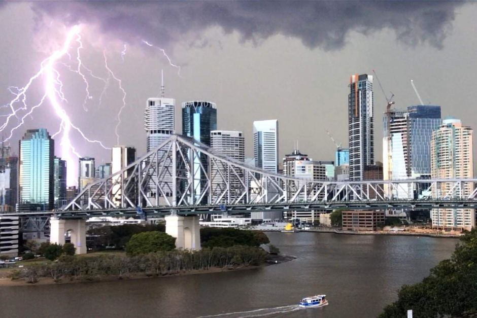
A huge thunderstorm moved over downtown Brisbane, Australia, on Tuesday, creating an ominous backdrop for some stunning photos.
A storm front carrying heavy rain, hail and strong winds gathers ominously to the west of Brisbane, Australia, on Sept. 29, 2015.
(Rex Features via AP Images)
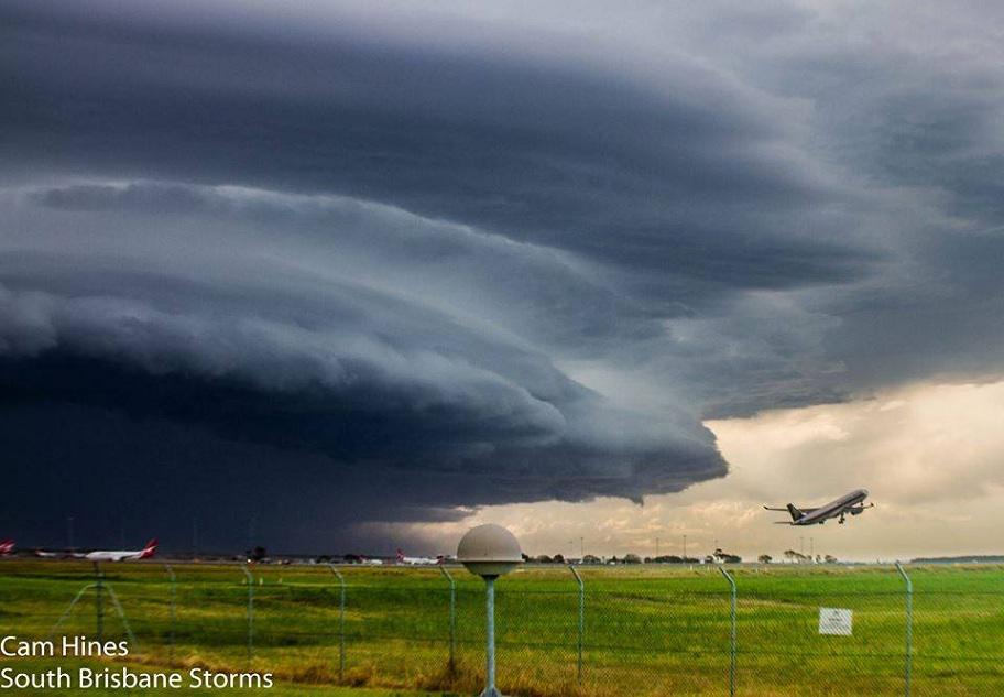
The storm eventually brought heavy rainfall, lots of lightning and hail, News Australia reported. Flights were delayed in and out of Brisbane Airport, and nearly 5,000 homes lost power, the report added.
(MORE: Huge Sinkhole Swallows Campground in Queensland)
The storms created at least 10,000 lightning strikes in southeastern Queensland state, News Australia also said. That gave photographers, both amateur and professional, opportunities to capture some incredible imagery of the storms.
Severe weather returned to the area Wednesday, and more storm warnings were issued, according to the Brisbane Times.
Brisbane, the capital of Queenslandi on Australia's eastern coast, is home to about 2 million people.
We've found a few more images on social media that show the storm, which you can see below.
MT @KeraunosObs: Nearly 10,000 lightning strikes reported in during yesterday’s storm | Pic: Vicki McInnes

WOW! Angry clouds seen yesterday from the airport in , Australia. Photo: Cameron Hinezy.

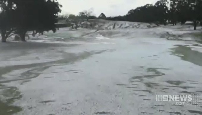
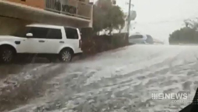
Brisbane's storm season is off to a dramatic start with suburbs blanketed in hail during a powerful downpour.

: 10,000 lightning strikes recorded as hailstorm hits http://ab.co/1LYOZ6T 

MORE: From Nov. 2014 – Storm Slams Brisbane

Fairbanks, Alaska Sees Record September Daily Snow; Thousands Without Power, Trees Downed

Jon Erdman
Published: September 30,2015

For the second time in less than a week, Fairbanks, Alaska, was blanketed with heavy snow. This time, it was a record-breaker.
Snow blankets the University of Alaska-Fairbanks campus on September 29, 2015.
(@lucas.nbraga/Instagram)
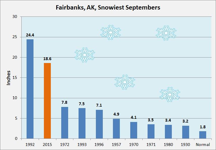
Officially, 11.2 inches of snow blanketed Fairbanks International Airport Tuesday, setting an all-time September daily snow record, previously 7.8 inches on Sep. 13, 1992.
This also topped the previous record for any 24-hour September snowfall of 9 inches in 1992, according to Rick Thoman from the National Weather Service in Fairbanks. Records in Fairbanks date to 1904.
Golden Valley Electric Agency reported an estimated 7,000-9,000 customers without power as of early Wednesday morning in Fairbanks and in nearby areas. This was down from a peak of about 13,000 customers Tuesday evening, or roughly 30 percent of their total customers.
(NOW: Wunderground Live Weather Webcams)
Heavy snow blankets Fairbanks, Alaska, on Sep. 29, 2015.
(@chrisjehull/Instagram)


Crews and contractors worked through the overnight hours clearing downed trees and branches. Photos from the Fairbanks Daily News-Miner showed some deciduous trees had yet to shed all their leaves.
NWS-Fairbanks reported up to 17 inches of snow had accumulated in the Fairbanks area as of early Wednesday morning, with numerous reports of fallen trees.
The concern Wednesday was for increased winds behind a cold front adding more stress to trees and powerlines already weighed down by heavy, wet snow.
(FORECASTS: Fairbanks | Anchorage)
Fairbanks schools were closed Wednesday due to the power outages and treacherous road conditions.
The Alaska DOT reported "very difficult" road conditions along the Park Highway southwest of Fairbanks and advised no travel on the Denali Highway between Paxson and Denali National Park.
Not to be outdone, the first measurable snow of the season blanketed Anchorage, with 2.8 inches officially measured at the National Weather Service office as of mid-morning Wednesday.
The first snow of the season blankets this street in Anchorage, Alaska, on Sep. 30, 2015.
(@Collinblank/Instagram)


In the mountains east of Anchorage, up to 9 inches of snow accumulated near Flat Top Mountain.
This first measurable snow is just over two weeks earlier than average in Anchorage, with the 30-year average date this occurs on Oct. 15.
This comes on the heels of a record least snowy 2014-2015 season in Anchorage, during which only 25.1 inches of snow fell. Their first measurable snow last season didn't occur until October 19.
Alaska-based climatologist Brian Brettschneider also added Anchorage set its record wettest September and fourth wettest month overall, thanks to a soaking of rain before Tuesday and Wednesday's first accumulating snow.
Fairbanks has now had two of its three snowiest September days of record within the past four days. Friday, September 25 (6.7 inches) was the city's third heaviest calendar-day September snow on record.
These latest events were the city's heaviest September snow event since a four-day, 17.3-inch snow blitz from Sep. 11-14, 1992.
Fairbanks only averages 1.9 inches of snow during the month of September.
Fairbanks with 11.2" of snow yesterday! Snowiest Sept day on rec. Second snowiest month of Sept.on rec. @StuOstro

The average date of the season's first measurable snow in Fairbanks is September 30, according to according to Brettschneider.
Brettschneider also said September monthly snow totals in excess of a foot have happened in numerous Alaska locations in the past.
Snow falling in Alaska's mountains in late summer is known locally as "termination dust," marking the eventual end of summer's warmth.
Nonetheless, Alaska has been quite chilly the past couple of weeks, even relative to mid-late September averages.

Recent Pattern Keeping Alaska Chilly (Mid-Late Sep. 2015)
The polar jet stream has taken a sharp southward plunge over Alaska, the northeast Pacific Ocean and western Canada, locking in a chilly, wet pattern over our 49th state.
This is quite a sharp turnaround. The first eight months of 2015 were the second warmest such period in Alaska on record, topped only by 1981.
Wildfires consumed over 5 million acres in the state, second only to 2004 in terms of acres burned in any year.
Incidentally, the season's last measurable snow in Fairbanks typically occurs around mid-April (April 17).

MORE: Deep Snow Around the World (PHOTOS)

October Temperature Outlook from The Weather Channel

September 30,2015
A cooler than average October is expected in parts of the South and East while the Northwest sees much above-average temperatures, according to a temperature outlook released by The Weather Channel Professional Division on Wednesday.
The forecast says that changing conditions in the tropical Pacific will result in a more El Niño-like pattern in the U.S. during October.
"We expect a more El Nino-like pattern to become established in October, with generally above-normal temperatures across most of the northern U.S. and stormy and cool conditions across the south-central and southeastern states," said Dr. Todd Crawford, chief meteorologist of WSI, a division of The Weather Company.
(MORE: Strong El Niño to Last Through Winter)
The southern Plains and lower Mississippi Valley are forecast to see temperatures the farthest below average in October. Conversely, a swath of the West from central California to Oregon, Washington, Idaho and western Montana is expected to see temperatures the farthest above average.
October 2015 temperature forecast.


During late-fall and winter, a moderate to strong El Niño typically favors cooler than average temperatures in parts of the southern United States, while the northern states see warmer-than-average temperatures. This October forecast resembles the type of temperature pattern that is expected late this fall into winter due to El Niño's influence.
(MORE: Winter 2015-16 Forecast)
The forecast for above-average warmth in the Northwest is a familiar sight for that region of country since it had record warm summer. That said, September has provided a bit of a break with temperatures near or even below-average temperatures so far.

MORE: Fall in Every State

Hurricane Joaquin's Bahamas Impacts: Shelters Open, Soldiers Called Back to Duty

Sean Breslin
Published: September 30,2015

Bahamians have been told that Hurricane Joaquin is bearing down on several of the nation's islands, and catastrophic damage could result.
More than 10,000 residents of the Bahamas are in the direct path of the large tropical system, according to CNN.com, and authorities have warned them to shelter in a sturdy location as soon as possible.
"Preparations to protect life and property should be rushed to completion," the U.S. National Hurricane Center said Wednesday.
The Government of the Bahamas has issued a Hurricane Warning for the Northwestern Bahamas including the Abacos, Berry Islands, Eleuthera, Grand Bahama Island, and New Providence, but excluding Andros Island and Bimini, according to the National Hurricane Center.
Delta Airlines released a statement offering refunds or free rebookings for passengers travelling to Freeport, Georgetown and Nassau between September 30 and October 2.
(MORE: America Prepares for Joaquin | Forecast | 5 Things You Should Know)
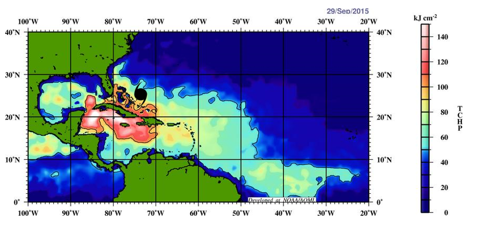
Why is a slow moving not having cold water upwelling issues? Very deep warm water near the Bahamas!

Bahamian news website Tribune 242 said all vacation leave has been canceled for marines and officers in the Royal Bahamas Defence Force, and all are expected to return to duty as they prepare for emergency response.
Public schools were closed Wednesday in Exuma, San Salvador, Cat Island and Rum Cay, the report added. Many shelters have opened for residents looking for safety; you can see a complete list here.
At least three cruise ships have made alternate itineraries due to the storm, according to Cruise Critic. A Disney Cruise Lines spokesperson confirmed that at least two Disney crusises have changed their schedules.
This is a developing story; please check back frequently for updates.
MORE: Flooding Soaks the Mid-Atlantic, Northeast

Hurricane Joaquin: East Coast Begins to Prepare

Sean Breslin
Published: September 30,2015

President Obama has been briefed about preparations and potential impacts for Hurricane Joaquin in case it hits the east coast of the United States in the coming days, officials told USA Today. White House spokesman Josh Earnest said the preparation includes "millions of liters of water, millions of meals and hundreds of thousands of blankets strategically located at distribution centers throughout the United States and its territories."
East Coast residents, some of which who have already seen plenty of rainfall and flooding this week, are being told to prepare for the possibility that Hurricane Joaquin may bring more disaster to their region. Even if Joaquin doesn't make it to the U.S., parts of the eastern states will see flooding rainfall, coastal flooding and gusty winds from the larger-scale weather pattern.
Grocery stores in Fairfax, Virginia are already seeing runs on bottled water due to possible impacts from Hurricane Joaquin.
(Twitter/Mark P.)
Parts of the coastline, which suffered damage and erosion from strong onshore winds and the weekend's King Tides, have been thrust back into preparation mode with Joaquin just days away from a possible landfall. Places like Surf City, North Carolina, are working tirelessly to clean the beaches and repair any damage they can before the next storm comes, according to WECT.com.
“We’ve had a fair amount of rain during the past week and the ground is saturated in many places,” North Carolina Governor McCrory said in a statement to the press. “The combination of wind gusts from various weather systems and any additional rain from Joaquin could lead to downed trees and power outages in many areas, not just the coast.”
 
State Emergency Management Director Mike Sprayberry said the state can expect flooding in poor-drainage spots and low-lying areas. "Regardless of the impact of Hurricane Joaquin, North Carolina has the potential for life-threatening flooding within the next week. We don’t know yet how much or how widespread the flooding will be, but we know there will be flooding.”
A small mudslide was triggered by this week's rainfall in Staunton, Virginia, the News Leader said – a scary sight with the thought of so much more rain possible in the coming days. As far north as Pennsylvania and beyond, residents of low-lying areas have been told to prepare for the possibly of flooding if the storm aims at their region, according to the Associated Press.
The NFL is discussing what impacts the storm might have on the Washington Redskins and Philadelphia Eagles game Sunday, the Washington Post reports, as well as potential scheduling contingencies in case Hurricane Joaquin hits the D.C. area this weekend.
“We are monitoring the forecast and having dialogue with both teams,” said Greg Aiello, the NFL’s senior vice president of communications. No specifics on when or where the game wopuld be rescheduled have been released.
(MORE: Forecast for Joaquin | 5 Things to Know | Joaquin vs. Sandy)
Hurricane Joaquin spins in the Caribbean on Wednesday, Sept. 30, 2015.
(NOAA via Getty Images)
Residents of the Northeast, fewer than three years removed from the horrors of Superstorm Sandy, are preparing in case another tropical system slams into the coast. New Jersey, which suffered some of the most severe coastal damage, is making preliminary preparations in case Joaquin veers toward the Garden State.
“Until we know the path for sure, we are doing general preparations, such as making sure all our vehicles are fueled and having Public Works crews clean out storm drains in problem areas. The beach was already cleaned up at the end of the season,” Ventnor, New Jersey, Emergency Management Coordinator Donna Peterson told Shore News Today.
Much the same is happening in New York, where authorities are making sure they're ready to elevate preparations and messaging if Joaquin's path shifts toward them.
"Our state has seen the damage that extreme weather can cause time and time again — and I am urging New Yorkers take precautions for more heavy storms in the coming days," said New York Gov. Andrew Cuomo, in a statement.
Consolidated Edison, which Reuters reports is in Year 3 of a four-year plan to fortify New York's power infrastructure, hasn't raised alert levels yet but has begun preparing equipment and crews in case they're needed for emergency utility restoration.
Now, the East Coast can only watch and wait to see which region's worst fears will be realized.
MORE: East Coast Flooding

Eastern U.S. Flood Threat to Continue No Matter Where Hurricane Joaquin Tracks (FORECAST)

Chris Dolce
Published: September 30,2015

The forecast for the East Coast is looking increasingly ominous as a complex weather pattern promises to deliver more heavy rainfall to a region that is already dealing with flooding from recent deluges.
Thursday through this weekend, deep tropical moisture from the Caribbean Sea and the western Atlantic will be involved in this soaking setup as a front stalls near the East Coast.
Significant impacts are likely in portions of the East, whether Hurricane Joaquin tracks towards the United States or not, due to the large-scale weather pattern taking shape. This will include, flash flooding, river flooding, gusty winds, high surf, beach erosion and some coastal flooding at high tide.
(MORE: Latest on Joaquin)
Heavy rain that impacted northern New England on Wednesday has since moved out of the area. This batch of moisture-rich air came from the Gulf of Mexico and fueled torrential downpours along a slow-moving cold front. This brought significant flooding to parts of Virginia, New York, North Carolina, Maine, Maryland, Pennsylvania and Ohio.
Several daily rainfall records were set on Wednesday in New England, some of which include Portland, Maine with 5.56 inches (previous record was 2.14 inches in 1920), Boston, Massachusetts with 2.46 inches (previous record was 1.26 inches in 1899) and Providence, Rhode Island with 2.02 inches (previous record was 0.95 inches in 1946).
(MORE: Serious Flooding Reported in Multiple States)

Rainfall Totals Since Sept. 23
The National Weather Service continues flood watches through Thursday morning for parts of Maine.
(MAPS: Interactive Radar | Flood Alerts)


Current Radar

Thursday Through This Weekend: More Heavy Rain; Wind, Coastal Impacts Possible

As the aforementioned front stalls, a jet stream dip will dig south across the eastern states. This will allow one or more waves of low pressure to develop along the front, helping to pull more rain into parts of the East.

Setup Late Week-Weekend
At the same time, strong high pressure in eastern Canada will help create a large pressure gradient along the East Coast, increasing the potential for gusty winds, coastal flooding, high surf and beach erosion.
The rain and coastal impacts would begin in advance of any threat from Hurricane Joaquin. Uncertainty remains high on where Joaquin will eventually track. However, even if the center does not make a direct hit on the U.S., rich tropical moisture will still be involved in the soaking setup in the East. For more details on the uncertainties with Joaquin, click the link below.
(MORE: Latest Forecast for Hurricane Joaquin)
Here are the potential impacts on the table starting Thursday and lasting through this weekend, no matter whether Joaquin approaches the U.S. or not:
Rainfall, Flooding: River flooding and flash flooding are both likely in parts of the East. There is uncertainty regarding where the heaviest rain may occur; however, areas from the Mid-Atlantic to the central Appalachians and the Carolinas appear to be the epicenter for the heaviest rainfall amounts. Totals could exceed 5 inches in many locations, with some areas having the potential to see a foot of rain. Areas farther north into New England should also monitor this situation as well.

Rainfall Forecast: Next 7 Days
Increasing Winds: The gradient between lower pressure near the stalled front and a strong area of high pressure anchored from eastern Canada into the Midwest will help increase winds late this week. Depending on how this weather pattern unfolds, the strong winds could impact coastal areas of the Northeast and Mid-Atlantic right through this weekend. If Joaquin approached the U.S. coast, there would be a core of much stronger winds, but that remains very uncertain.
The National Weather Service has already hoisted high wind watches valid Friday and Saturday for parts of southern New Jersey in anticipation of this windy setup, which could produce gusts of 50 to 60 mph.
Coastal Impacts: The winds could contribute to high surf, beach erosion and coastal flooding in some locations along the Northeast and the Mid-Atlantic coast.
The National Weather Service has issued coastal flood watches for the Jersey shore, the Delaware beaches, and areas surrounding Delaware Bay and the tidal section of the lower Delaware River, including Philadelphia.
According to the watch bulletin, major coastal flooding may occur along the Delaware beaches and the Atlantic-facing coastlines of Cape May and Atlantic counties in southern New Jersey. This means flooding may be severe enough not only to flood numerous roads in coastal areas, but also to flood homes and businesses.
Check back with weather.com for updates in the days ahead as we provide more specifics on this forecast.

MORE: Retired Atlantic Hurricane Names

Hurricane Joaquin: 5 Things You Should Know About the Storm

Chris Dolce
Published: September 30,2015

Hurricane Joaquin is spinning near the northeast Bahamas and expected to strengthen. It's future forecast path remains uncertain at this time, so be sure to check back frequently for the latest forecast changes with Joaquin.
Here are five things to know about Joaquin right now.

1.) Complex Weather Patterns Are Causing Future Track Uncertainty


Joaquin Projected Path
Why is there uncertainty with the future track of Joaquin?
The weather pattern evolving over eastern North America and the western Atlantic Ocean late this week is complex. The players include a stalled front near the East Coast, a strong area of low pressure aloft forming over the Southeast, the remnants of Tropical Storm Ida, and a strong area of high pressure aloft over the northern Atlantic Ocean.
How all of those features interact will play a big role in whether Joaquin moves towards the East Coast or stays out to sea. It's not uncommon to have a large amount of uncertainty with a forecast track 4-5 days in advance of a direct hit from a tropical storm or hurricane. Average track errors in the 4-5 day forecast range have been between 158-210 nautical miles in the last five years, according to the National Hurricane Center.
Bottom line, if you live on the East Coast, now is the time to prepare even with the forecast uncertainty. Don't wait until it's too late.
You can find more details on the forecast and what we know right now on our main Joaquin forecast page at the link below.
(MORE: Joaquin Forecast)

2.) There Will Be Major East Coast Impacts Even if Joaquin Stays Out to Sea


Rainfall Forecast
Regardless whether Joaquin directly hits the United States or not, the East Coast will still see significant impacts from the large-scale weather pattern taking shape.
Heavy rain could cause major flash flooding and river flooding from portions of the mid-Atlantic into the Carolinas and the central Appalachians starting Thursday and continuing into the weekend. If Joaquin does make a run at the U.S. coast, this heavy rain threat would precede the storm.
In addition to the flood threat, high surf, beach erosion and coastal flooding will impact the East Coast late week into the weekend. This is due to a strong area of surface high pressure in eastern Canada combining with lower pressure near the East Coast, resulting in a strong onshore wind flow.
For more on the East Coast flood threat, click the link below.
(MORE: Eastern Flood Threat No Matter Where Joaquin Tracks)

3.) Joaquin Originated From System That Moved Off the U.S. Coast Two Weeks Ago

Believe it or not, Joaquin actually originated from an upper-level weather system that moved off the Carolina coastline about two weeks ago, according to senior meteorologist Stu Ostro of The Weather Channel.
Ostro said, "Joaquin's origin can be traced in part all the way back to a upper-level trough that came off the coast of the Carolinas on Sept. 15 (yeah, really!), then became a cold upper low northeast of the Leewards, then warmed and transformed, exemplifying how tropical cyclones can arise from non-tropical systems."
Now there is a chance that Joaquin could return to the East Coast depending on the ultimate outcome of its uncertain track.

4.) This Is the First Time the Name Joaquin Has Been Used


Storm Information
This marks the first time Joaquin has been used as a storm name in the Atlantic Basin or any other basin worldwide. The name replaced "Juan" after its retirement in 2003. Joaquin was first eligible for use in the 2009 season, but the final storm that year was named Ida; Joaquin was next on the list.
Juan was retired after it caused major damage in the Canadian Maritimes in 2003.
Atlantic hurricane and tropical storm name lists repeat every six years, unless one is so destructive and/or deadly that the World Meteorological Organization votes to retire that name from future lists. This avoids the use of, say, Andrew to describe a future weak, open-ocean tropical storm.
(MORE: Retired Hurricane Names)

5.)  This Could Become the First U.S. Hurricane Landfall in More Than a Year

The U.S. coastline has not had a direct hit from a hurricane in more than a year.
Hurricane Arthur was the last one on July 3, 2014, when it made landfall in the Outer Banks.
Arthur was the first hurricane to make landfall in the continental U.S. since Hurricane Isaac struck Louisiana on Aug. 28-29, 2012. (Sandy, in October 2012, became post-tropical shortly before landfall.)
Arthur was also the first hurricane of Category 2 or greater strength to make landfall in the Lower 48 since Hurricane Ike struck Texas on Sept. 13, 2008.

MORE: Retired Atlantic Hurricane Names

Joaquin, Becomes a Major Hurricane, Impacting Bahamas; U.S. East Coast Landfall Remains Possible

September 30,2015
Hurricane Joaquin strengthened to major hurricane status as a Category 3 storm Wednesday night, as it moves dangerously close to the Bahamas, and prospects are looking increasingly worrisome for the U.S. mainland as the official forecast raises the odds of the East Coast seeing its first landfalling hurricane in 15 months.
Joaquin will pass dangerously close to Samana Cays island through Thursday morning, moving toward Rum Cay and San Salvador islands later Thursday. With the Category 3 hurricane passing close to the islands at a relatively slow speed, and perhaps even intensifying to Category 4 status, a catastrophic situation may unfold there with a prolonged period of intense hurricane conditions.
Hurricane warnings have been expanded to include more of the Bahamas as Hurricane Joaquin churns toward the nation of islands east of Florida.
(MORE: Expert Analysis | Hurricane Central)
An Air Force Reserve Hurricane Hunter reconnaissance aircraft flying through Hurricane Joaquin Wednesday night found winds near the center had become much stronger, prompting the agency to raise the wind figure to 105 mph in the 8 p.m. advisory and 115 mph at 11 p.m. The latter makes Joaquin a Category 3 hurricane on the Saffir-Simpson Hurricane Wind Scale.
Equipment on the plane measured surface winds as high as 130 mph in gusts within powerful thunderstorms in the developing eyewall in the still-growing tropical cyclone.
With Joaquin strengthening 30 mph within a 24-hour period on Wednesday, rapid intensification criteria has been met. Further strengthening is expected in the coming days.

Hurricane Joaquin Information
Hurricane Joaquin continues to intensify as wind shear – harmful to the intensification of tropical cyclones – lessens, and a complicated atmospheric pattern makes its future track – including any potential landfall on the U.S. East Coast – extremely difficult to forecast.
Residents along the East Coast of the U.S. should pay close attention to the forecast now through this weekend. It's a particularly difficult forecast that hinges on the behavior of several different atmospheric features over North America and the North Atlantic Ocean.

Aware Threat Index
Computer forecast models – and the meteorologists who rely on them for guidance – are grappling with a complex interaction between Joaquin, a cold front near the East Coast, the remnants of Tropical Storm Ida, a strong bubble of high pressure aloft over the North Atlantic Ocean, and a potentially strong area of low pressure aloft digging into the southeastern U.S. later this week.

Ensemble Forecast Model Tracks
Joaquin's future depends critically on the position and relative strength of those players – not to mention its own strength. Strong wind shear had kept most of Joaquin's thunderstorm activity (convection) south or east of its center of circulation, but that changed Tuesday afternoon and evening as thunderstorms developed closer to its circulation center.
(MORE: Expert Analysis | Hurricane Central)

Visible Satellite
Because Joaquin is strengthening and drifting ever closer to the Bahamas, the government of that country has issued warnings and watches for much of its territory. Here are the details as of 8 p.m. EDT:
  • A hurricane warning is now in effect for the northwestern Bahamas including the Abacos, Berry Islands, Eleuthera, Grand Bahama Island, and New Providence, but excluding Andros Island and Bimini.
  • A hurricane warning remain in effect for the central Bahamas, including Cat Island, the Exumas, Long Island, Rum Cay and San Salvador.
  • A hurricane watch is now in effect for Bimini.
  • A tropical storm warning is now in effect for the southeastern Bahamas including the Acklins, Crooked Island, Long Cay, the Inaguas, Mayaguana, and the Ragged Islands, but excluding the Turks and Caicos Islands.

Hurricane Joaquin: Watches and Warnings
Hurricane preparations should be rushed to completion in the hurricane warning area.
(MORE: Bahamians Prepare for Hurricane Joaquin)
Joaquin is expected to slowly churn toward the Bahamas through Thursday. The extent of the effects on those islands will depend heavily on how close it gets and how much time it spends nearby before making the anticipated northward turn.
At this time, we expect some of the worst impacts in the Bahamas to occur on San Salvador and Rum Cay, the islands closest to Joaquin's current position. On San Salvador, rainfall totals could exceed 2 feet. Sustained tropical-storm force winds of 39 mph or greater may develop Wednesday night and continue unabated for 48 hours or more.

Track Forecast: Still Extremely Challenging

Although computer model simulations have had the advantage of ingesting high-resolution real-world data from the Air Force reconnaissance flight earlier in the day, it doesn't seem to have brought them any closer to a consensus.
The American GFS model forecast continues to show Joaquin making an alarming northwestward turn, slamming it right into Virginia, Maryland or North Carolina this weekend. Meanwhile, the European ECMWF model suggests Joaquin has a chance of staying away from the U.S. East Coast.
It is simply too soon and the uncertainty is too high to determine any impacts from Joaquin itself for the U.S. East Coast at this time.
The National Hurricane Center's official forecast cone is below. The official forecast remains a compromise between the competing scenarios from the computer models.
(MAP: Track Hurricane Joaquin with our New Interactive Storm Tracker)

Projected Path
Note that the official intensity forecast now brings Joaquin to Category 3 strength on Saturday morning, which by definition would make it a major hurricane.
Regardless of the ultimate outcome of Joaquin's path, portions of the East Coast will still see multiple impacts from the evolving large-scale weather pattern, including flooding rainfall, gusty winds, high surf, beach erosion and some coastal flooding. Click the link below for more information on that story.
(MORE: Significant Impacts Likely on East Coast)

Late Week and Weekend Setup
In summary, here's what we know about Joaquin as of Wednesday's 11 p.m. EDT advisory:
  • Hurricane Joaquin's center is located about 90 miles east of the central Bahamas.
  • Maximum sustained winds are estimated at 115 mph, a Category 3 hurricane on the Saffir-Simpson hurricane wind scale.
  • As wind shear over the storm lessens, Joaquin should strengthen further over the next 2 to 3 days.
  • This system is moving slowly to the southwest and this is expected to continue through Thursday before turning north Friday into Saturday.
  • Hurricane watches and warnings are in effect for parts of the Bahamas.
  • Joaquin may directly or indirectly affect the East Coast late this weekend or early next week, and a landfall is possible.
  • Moisture and/or energy associated with Joaquin could enhance rainfall along the cold front in the Northeast late this week. Regardless, the East Coast will see significant impacts from the larger scale weather pattern taking shape.
MORE: Retired Atlantic Basin Hurricanes and Tropical Storms (PHOTOS)

Major Hurricane Joaquin to Hammer US East Coast With Flooding, Strong Winds

By , AccuWeather.com Senior Meteorologist
September 30,2015; 11:25PM,EDT
 
 
While there are still scenarios that would take Hurricane Joaquin out to sea, the possibility of the hurricane reaching the Eastern United States coast is gaining merit.
Joaquin Strengthening; Mid-Atlantic Coast on Alert for Weekend
Hurricane Joaquin is rapidly intensifying. Joaquin reached Category 3 status late Wednesday evening. The storm is now expected to strengthen into a Category 4 storm sometime late Thursday or Thursday night.
After it passes just northeast of the Bahamas Thursday, Joaquin will begin to turn north and parallel the East Coast on Friday and Saturday.
JUMP TO: Joaquin Track Scenarios | Inland Flooding | Coastal Flooding, Strong Winds
The storm will bring pounding surf, dangerous seas, strong winds, drenching squalls and flash flooding to the central Bahamas. Wind gusts could reach between 75 and 100 mph on some of the islands.
As a result, Joaquin will threaten lives and property in the Bahamas through Thursday, before turning northward.
Virginia Governor Terry McAuliffe issued a state of emergency on Wednesday night throughout the entire state in response to the recent flooding and in preparation for Joaquin.
Governors in surrounding mid-Atlantic states are closely monitoring the progress of the storm even though emergency declarations have not been issued.
Joaquin Track Scenarios

The most likely scenario is for Joaquin to be guided westward this weekend with possible landfall between North Carolina and southern New Jersey on Sunday.
Exactly where the system rolls ashore and progresses inland will define the worst conditions in terms of wind and flooding. It is too early to say for sure exactly where Joaquin may move onshore.

Should Joaquin track into northeastern North Carolina, conditions may get very nasty over the Delmarva Peninsula with significant rain, wind and coastal flooding westward to the Chesapeake Bay, including the Washington, D.C., and Baltimore areas. Conditions could approach that of Isabel.
Should Joaquin track into the Delmarva Peninsula, then similar very rough conditions would occur from Delaware to New Jersey, including areas westward through the Delaware Bay region, including Cape May, New Jersey, Rehoboth Beach, Delaware, and Philadelphia. Conditions could approach or exceed that of Irene.
A less likely path for Joaquin is to stay at sea directly avoid land, with less severe impact along the coast this weekend into early next week.
RELATED:
AccuWeather Atlantic Hurricane Center
Northeast Interactive Weather Radar
Bernie Rayno: Hurricane Joaquin to Unleash Flooding Along US East Coast

At this venture, people along the coast from the Carolinas to southern New England should be prepared for the possibility of hurricane conditions with everything from inland to coastal flooding and strong winds.
Many areas can expect rounds of heavy rain on top of what has already fallen with the next dose set to begin as early as Thursday night in the mid-Atlantic.
The result from the storms, whether or not topped off from Joaquin, will still produce widespread flooding.
Inland Flooding
Preceding the arrival or close approach of Joaquin will be another dose of heavy rain during Friday and this weekend. Motorists and airline passengers should be prepared for delays. Some neighborhoods could become flooded.

Many football fans heading to games this weekend will get drenched, and the likelihood of muddy parking lots exists. Baseball fans may have their last games of the regular season postponed.
Each subsequent round of rain will bring increasing runoff that will find its way from storm drains to streams and eventually larger rivers. As a result, flooding will progressively become more widespread.
Flash flooding along small streams and in urban areas is a given with the event through the weekend. Enough rain may fall to cause flooding along unprotected areas of rivers, perhaps including the New, Tar, Meherrein, Potomac, Shenandoah and James by early next week.
The combination of rain from earlier this week and what is expected to continue into early next week may approach a foot in some locations, hence the serious flooding.
Coastal Flooding, Strong Winds
Like flash and urban flooding, coastal flooding and beach erosion with this event are a given.
The coastal flooding and stiff winds will not wait until the day Joaquin arrives but will continue to build Friday through the weekend.
How severe the coastal flooding and winds become will depend on the strength and track of Joaquin this weekend.
The onshore winds from the east will push the Atlantic Ocean water toward the coast, causing it to pile up around the barrier islands, back bay and inland bays. This is known as coastal flooding.

If Joaquin remains a hurricane and plows onshore between North Carolina and the Delmarva Peninsula, major flooding at times of high tide are likely near and north of the storm's center.
In this case, water levels in some areas could rise to an average of 3-6 feet above normal tides up to a couple of hundred miles north of the center. Under this scenario, these conditions could reach as far north as New York City and Long Island Sound with lesser water rises in New England.
Even if Joaquin stays at sea and curves away, there will still be a non-tropical component of the storm that delivers minor to moderate coastal flooding and stiff winds over a broad area from the Carolinas to the New England coast.
The strength of the east to northeast winds will depend on the strength of Joaquin and or the non-tropical storm to the south. Winds could become strong enough to down trees and power lines and cause minor property damage.
Updates on the storm will be provided through AccuWeather.com, The AccuWeather Channel and AccuWeather's radio and TV affiliates.
 

Flooding Downpours Target Philippines; China and Vietnam on Alert from Tropical Depression

By , Senior Meteorologist
September 30,2015; 11:24PM,EDT
 
 
A tropical depression threatens to trigger flooding across the Philippines late this week before potentially strengthening this weekend as it approaches southeastern China and northern Vietnam.
Tropical downpours will accompany Tropical Depression 22 as it pushes across the northern half of the Philippines from east to west into Friday.

While the AccuWeather Typhoon Center is closely monitoring the depression, it is not expected to strengthen much before it reaches the Philippines.
AccuWeather Meteorologist Adam Douty states that the Philippines will be at risk for flash flooding.
"The greatest [flood] threat will be across Samar and southern Luzon, which could receive 75 to 100 mm (3 to 6 inches) of rain," he said. "Manila is included in this area."
RELATED:
Philippines Weather Center
AccuWeather Typhoon Warning Center
RECAP: Typhoon Dujuan Turns Deadly in Taiwan; Ryukyu Islands, China Endure Wind, Rain

Even though the depression will struggle to strengthen prior to reaching the Philippines, there is greater concern for the low to intensify over the warm waters of the South China Sea this weekend. Disruptive wind shear will not hinder the low's ability to strengthen.
"During this time, a continued track to the west-northwest is expected, along with further development," Douty said. "Due to this, areas from northern Vietnam into southern China (to the west of Hong Kong) should be on alert for a tropical system."
Among the cities that are being put on alert for potential impacts later this weekend or early next week include Zhenjiang and Haikou, China, and Hai Phong and Hanoi, Vietnam.
NOAA Releases Latest Satellite Imagery of Hurricane Joaquin
"At the least, [the low] would bring the threat for flooding to the region," Douty continued. The danger of damaging winds and an inundating storm surge will increase as the low strengthens.
AccuWeather will continue to provide updates on the potential for the depression to strengthen and any impacts in the coming days.
 

How Will Joaquin Compare to Superstorm Sandy, Hurricane Isabel?

By , AccuWeather.com Senior Meteorologist
September 30,2015; 11:23PM,EDT
 
 
Questions have been raised about the similarity to Joaquin with other recent hurricane strikes in the mid-Atlantic states.
According to Mike Smith, senior vice president and chief innovation executive of AccuWeather Enterprise Solutions, "There is going to be catastrophic flooding from North Carolina to Massachusetts, and this is going to disrupt the economy regardless of whether or not Hurricane Joaquin makes landfall."
No matter how similar the pattern may seem, no two storms are ever exactly alike. The same can be said about the situation developing this weekend along the Atlantic coast with the approach of Joaquin.

A slightly different storm track and the position of other weather systems nearby can translate to huge differences in the weather that occurs at a particular location. The angle and strength of the storm's approach compared to geography and whether or not the storm is strengthening or weaken at landfall can be huge factors in the severity of the weather that occurs.
Satellite: Side-by-side photos of Sandy (left) on Oct. 28, 2012, and Isabel (right) on Sept. 18, 2003. (MODIS Rapid Response Team NASA/GSFC)
Joaquin will deliver beach erosion, coastal flooding, inland flooding from heavy rain and stiff winds near the coast, prior to its arrival more than 100 miles away from the point of any landfall.
Exactly where Joaquin comes ashore and how strong it is at landfall will determine the severity of the conditions from the Outer Banks of North Carolina to the Delmarva Peninsula, New Jersey and the New York City area and as far inland as Washington, D.C., Baltimore and Philadelphia.
For the number of people now living along the mid-Atlantic coast that did not experience Sandy or Isabel, this storm could deliver rough weather. In both Sandy and Isabel, gusty winds and flooding occurred well away from the center of the storms.
Hurricane Joaquin to Hammer Mid-Atlantic With Flooding
RELATED:
Hurricane Joaquin to Hammer US East Coast With Flooding, Strong Winds
BLOG: Future Joaquin is No Sandy but Could Get Interesting
NYC: Flooding Risk to Escalate Into Next Week

Superstorm Sandy
In October 2012, Sandy originated from the western Caribbean and paralleled the southern Atlantic coast into Oct. 28, before making the abrupt left turn toward the New Jersey coast.
Areas from coastal central New Jersey to Long Island and the New York City area, which were located just north of Sandy's landfall, experienced the worst coastal flooding and damaging winds.

High pressure to the north helped to funnel winds in from the east and direct Sandy westward. The shape of the coast of northern New Jersey and Long Island helped to funnel the Atlantic Ocean water.
Sandy was the second costliest hurricane in United States history with damage at $75 billion. More than 200 people lost their lives from the Caribbean through the U.S.
Hurricane Isabel
In September 2003, Isabel originated from off the west coast of Africa and took a direct northwestward path from just northeast of the Bahamas and into eastern North Carolina.
This path flung the strongest winds over the Chesapeake Bay region. In addition to heavy rain, Atlantic Ocean and bay waters were funneled up the Chesapeake Bay, which resulted in substantial damage. The increasing forward speed of Isabel helped to maintain strong wind gusts well inland.

Isabel resulted in approximately 16 direct fatalities, more than 30 indirect deaths and caused $5.4 billion in damage.
Prepare Now Regardless of Similarities, Differences
While there will be no Tropical Storm Henri arriving ahead of Joaquin, unlike in 2003, there has been heavy rainfall prior to Joaquin this time.
The impact from Joaquin, assuming it makes landfall, could be similar to either Sandy or Isabel or perhaps a blend of the two. There will be impacts. This includes the potential for flooding, downed trees, property damage and power outages. Areas from northeastern North Carolina to New York City, including the Delaware and Chesapeake bay regions will especially monitor Joaquin's track and intensity through this weekend.
In terms of loss of life or injury, be sure to heed warnings and orders as soon as they are issued. Protect property by moving items out of harms way to higher floors or a safe location inland, ahead of the storm. People along the mid-Atlantic coast have several days to prepare for Joaquin, should it make landfall in their vicinity.