Published: June 6,2017
For those in the East who have had enough of the cool, wet weather during the last several weeks, maybe this will brighten (no pun intended) your day.
A pattern flip is in the works this coming weekend, which will send temperatures to levels more typical of early June and bring more frequent sunny, dry days.
Many areas of the Northeast, Midwest and South saw a wetter-than-average May due to a persistent southward plunge of the jet stream, or trough, over the East. This trough has repeatedly taken hold of the East into early June as a blocking upper-level area of high pressure remains parked near Greenland.
(MORE: Eastern Rain Fatigue)
Over the weekend, however, the jet stream will bulge northward into southeastern Canada, allowing high pressure to develop at the surface over the eastern U.S. This means there will be an increased chance for near- to above-average temperatures and lower chances for rain or thunderstorms.
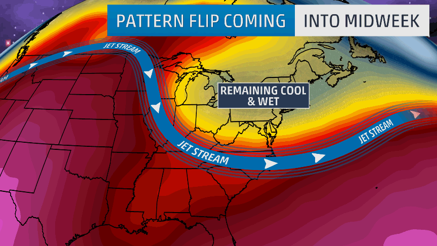 The
weather pattern into midweek will feature an upper-level trough over
the East, keeping cool and wet conditions across the region. This coming
weekend, an upper-level ridge will develop, allowing warmer air to
build in the East.
The
weather pattern into midweek will feature an upper-level trough over
the East, keeping cool and wet conditions across the region. This coming
weekend, an upper-level ridge will develop, allowing warmer air to
build in the East.Showers may linger for New England as a low-pressure system pushes eastward and its trailing cold front slides across the region.
Most areas will see less than an inch of rain.
(MAPS: 48-Hour Rainfall Forecast)

Rainfall Forecast Through Tuesday
In addition to the unsettled conditions, temperatures will be 5 to 15 degrees cooler than average in the Ohio Valley and portions of the South through Thursday. Highs will warm up into the 60s and 70s in parts of the Northeast on Wednesday, while temperatures will be in the upper 70s to lower 80s in much of the South.
(MAPS: 10-Day Forecast Highs/Lows)

This Week's Forecast
This means the Northeast will be mainly in the 70s and 80s, with the South seeing temperatures in the 80s to lower 90s.
(MORE: June 2017 Temperature Outlook)
New York City will only see highs in the upper 60s Wednesday, but temperatures could reach the mid-80s by Sunday.
Boston struggled to get out of the 40s on Tuesday, but highs near 80 degrees are possible Sunday.

Forecast Highs
It should be noted that this large-scale reconfiguration of the jet stream will have the opposite impact on the West Coast. Cooler-than-average temperatures, rain and even high mountain snow will push into the Northwest later this week.
MORE: Severe Weather – May 27, 2017
The Weather Company’s primary journalistic mission is to report
on breaking weather news, the environment and the importance of science
to our lives. This story does not necessarily represent the position of
our parent company, IBM.
No comments:
Post a Comment