By:
Jeff Masters
, 4:03PM,GMT on September 10,2015
Tropical Storm Henri
got its name on Wednesday evening in the waters a few hundred miles
east of Bermuda, but appears destined to be short-lived and quickly
forgotten. Henri is under moderate wind shear of 15 - 20 knots, which is
inhibiting development, but ocean waters are warm, near 28°C (82°F).
The 8 am EDT Thursday run of the SHIPS model
predicted that Thursday night through Friday night, Herni should find
moderate wind shear of 5 - 15 knots and a moister atmosphere, which
should allow it to intensify into a strong tropical storm. By Saturday
morning, Henri will have crossed over the warm waters of the Gulf Stream
into very cold waters of 17°C (63°F), which should cause a rapid
transition to an extratropical storm. Henri will pass close to southeast
Newfoundland, Canada on Saturday morning. Henri's formation date of
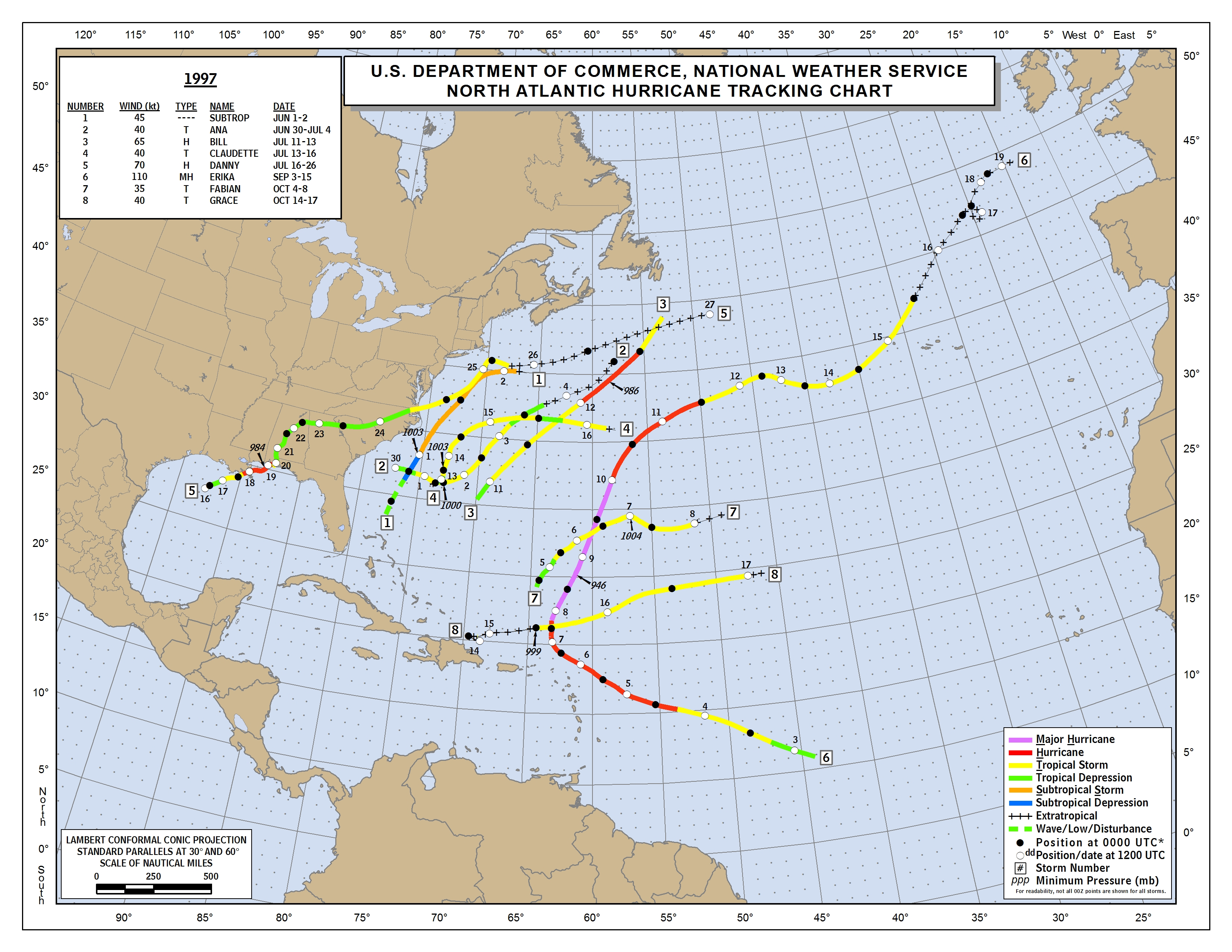
September 9 comes two weeks earlier than the usual September 24 formation date
for the Atlantic's eighth named storm of the year, and matches the
total number of named storms that occurred during the entire year the
last time we had a strong El Niño event--in 1997.
The Atlantic has seen close to average levels of activity this year: 8
named storms, 2 hurricanes, and 1 major hurricane; a typical season sees
6 named storms, 2 hurricanes, and 1 major hurricane by this point in
the season. However, this year's storms have been weaker and
shorter-lived than usual; our Accumulated Cyclone Energy (ACE)
index (25) is about half of average (50.) The official halfway point of
the Atlantic hurricane season is September 11, so we are halfway home!

Figure 1. Latest satellite image of Henri.
New African tropical wave worth watching
A tropical wave moving off the coast of Africa on Thursday has the potential to develop into a tropical depression early next week as it moves westwards across the Atlantic at about 15 mph. Though the wave does not yet have much spin or heavy thunderstorm activity, conditions are favorable for development, with wind shear a moderate 10 - 20 knots, ocean temperatures at 27.5 - 28.5°C (82 - 84°F), and only a modest amount of dry air from the Saharan Air Layer to the north of the disturbance. One of our three models for predicting tropical cyclone genesis, the UKMET model, forecasted in its 00Z Thursday run that the wave would develop into a tropical depression midway between the Lesser Antilles Islands and Africa by Sunday. Many of the 20 members of the GFS ensemble forecast also predicted development, though the operational high-resolution version of the GFS model did not. In their 8 am EDT Thursday Tropical Weather Outlook, NHC gave the wave 2-day and 5-day odds of development of 0% and 20%, respectively. This wave looks less likely to affect the Lesser Antilles Islands than the waves that spawned Grace, Erika, and Danny, but it is too early to be confident of this.
Gulf of Mexico disturbance next week
An area of disturbed weather is expected to form in the Western Gulf of Mexico's Bay of Campeche on Sunday or Monday next week. This disturbance will be capable of developing into a tropical depression, and could bring heavy rains to the coast of Mexico south of Texas early next week.

Figure 2. Tropical Storm Kilo as seen by the MODIS instrument on the Aqua satellite at 02:50 UTC September 10, 2015. At the time, Kilo had top winds of 65 mph. Image credit: NASA.
Kilo and Linda continue to churn the Pacific
In the Eastern Pacific off the coast of Mexico's Baja Peninsula, Tropical Storm Linda quickly weakened to a minimal-strength tropical storm with 40 mph winds at 11 am EDT Thursday. A northeasterly flow of moisture along the east side of Linda continues to stream into Northwest Mexico and the Southwest U.S., and will contribute to numerous thunderstorms with heavy rain over the next two days. Flash flood watches are posted for Southwest California for the regions just inland from San Diego to Los Angeles. Linda is expected to be dead by Friday. Long-lived Tropical Storm Kilo has finally weakened below hurricane strength, after being a Category 1 or stronger storm for thirteen days. Kilo became a tropical depression on August 20, and is now entering its 22nd day as a tropical cyclone. Kilo will move on a northerly path that will take it into the cold waters between Russia and Japan on Friday night, when it will finally die after 23 - 24 days as a tropical cyclone. According to the Hurricane FAQ, this will make Kilo one of the top-ten longest-lived tropical cyclones on record. In the Central Pacific waters about 300 miles north of Honolulu, Hawaii, Tropical Storm Jimena finally died on Thursday, after fifteen days as a tropical cyclone.
Video 1. A house floats away and a rooftop helicopter rescues occur in the floodwaters spawned by Japan's Tropical Storm Etau. Thanks go to wunderground member Xandra for posting this video in my blog comments.
Tropical Storm Etau deluges Japan
Tropical Storm Etau hit Japan just after 10 a.m. on Sept. 9 on the Chita Peninsula, Aichi Prefecture. A band of heavy rain set up over the northern Tokyo metropolitan area, bringing extreme rainfall and catastrophic flooding. The city of Ikari recorded 21.69" (551 mm) of rain in just 24 hours, and Nikko has received 26.30" (668 mm) since Sunday (thanks go to Maximiliano Herrera for the Ikari rainfall info.) For more details, see the news story by TWC's Nick Wiltgen.
The challenges NHC faced on predicting the path and intensity of Tropical Storm Erika are discussed by James Franklin, Branch Chief of the Hurricane Specialist Unit, in a September 9 blog post, After Further Review: Tropical Storm Erika.
Jeff Masters
Figure 1. Latest satellite image of Henri.
New African tropical wave worth watching
A tropical wave moving off the coast of Africa on Thursday has the potential to develop into a tropical depression early next week as it moves westwards across the Atlantic at about 15 mph. Though the wave does not yet have much spin or heavy thunderstorm activity, conditions are favorable for development, with wind shear a moderate 10 - 20 knots, ocean temperatures at 27.5 - 28.5°C (82 - 84°F), and only a modest amount of dry air from the Saharan Air Layer to the north of the disturbance. One of our three models for predicting tropical cyclone genesis, the UKMET model, forecasted in its 00Z Thursday run that the wave would develop into a tropical depression midway between the Lesser Antilles Islands and Africa by Sunday. Many of the 20 members of the GFS ensemble forecast also predicted development, though the operational high-resolution version of the GFS model did not. In their 8 am EDT Thursday Tropical Weather Outlook, NHC gave the wave 2-day and 5-day odds of development of 0% and 20%, respectively. This wave looks less likely to affect the Lesser Antilles Islands than the waves that spawned Grace, Erika, and Danny, but it is too early to be confident of this.
Gulf of Mexico disturbance next week
An area of disturbed weather is expected to form in the Western Gulf of Mexico's Bay of Campeche on Sunday or Monday next week. This disturbance will be capable of developing into a tropical depression, and could bring heavy rains to the coast of Mexico south of Texas early next week.
Figure 2. Tropical Storm Kilo as seen by the MODIS instrument on the Aqua satellite at 02:50 UTC September 10, 2015. At the time, Kilo had top winds of 65 mph. Image credit: NASA.
Kilo and Linda continue to churn the Pacific
In the Eastern Pacific off the coast of Mexico's Baja Peninsula, Tropical Storm Linda quickly weakened to a minimal-strength tropical storm with 40 mph winds at 11 am EDT Thursday. A northeasterly flow of moisture along the east side of Linda continues to stream into Northwest Mexico and the Southwest U.S., and will contribute to numerous thunderstorms with heavy rain over the next two days. Flash flood watches are posted for Southwest California for the regions just inland from San Diego to Los Angeles. Linda is expected to be dead by Friday. Long-lived Tropical Storm Kilo has finally weakened below hurricane strength, after being a Category 1 or stronger storm for thirteen days. Kilo became a tropical depression on August 20, and is now entering its 22nd day as a tropical cyclone. Kilo will move on a northerly path that will take it into the cold waters between Russia and Japan on Friday night, when it will finally die after 23 - 24 days as a tropical cyclone. According to the Hurricane FAQ, this will make Kilo one of the top-ten longest-lived tropical cyclones on record. In the Central Pacific waters about 300 miles north of Honolulu, Hawaii, Tropical Storm Jimena finally died on Thursday, after fifteen days as a tropical cyclone.
Video 1. A house floats away and a rooftop helicopter rescues occur in the floodwaters spawned by Japan's Tropical Storm Etau. Thanks go to wunderground member Xandra for posting this video in my blog comments.
Tropical Storm Etau deluges Japan
Tropical Storm Etau hit Japan just after 10 a.m. on Sept. 9 on the Chita Peninsula, Aichi Prefecture. A band of heavy rain set up over the northern Tokyo metropolitan area, bringing extreme rainfall and catastrophic flooding. The city of Ikari recorded 21.69" (551 mm) of rain in just 24 hours, and Nikko has received 26.30" (668 mm) since Sunday (thanks go to Maximiliano Herrera for the Ikari rainfall info.) For more details, see the news story by TWC's Nick Wiltgen.
The challenges NHC faced on predicting the path and intensity of Tropical Storm Erika are discussed by James Franklin, Branch Chief of the Hurricane Specialist Unit, in a September 9 blog post, After Further Review: Tropical Storm Erika.
Jeff Masters
No comments:
Post a Comment