By:
Bob Henson
, 2:00PM,GMT on January 6,2015
A sprawling dome of high pressure is on track to spill from Canada
across most of the eastern United States over the next several days,
bringing sharp winds and some of the coldest air of the season to many
locations. While the cold will certainly make its presence known, the
truly remarkable aspect of this blast will be the strength of the high
pressure itself. In some locations, barometric high pressure readings
may reach levels never before observed in January, and one or more
all-time records can't be ruled out.
Most high-pressure records east of the Rockies occur during the winter months, as darkness and snow cover allow frigid, dense cold air masses to develop and surge southward. Many all-time pressure records across the plains were established during the memorable cold wave of late December 1983, which sent temperatures down to 9°F as far south as San Antonio and kept Omaha lodged below 0°F for more than a solid week. On December 24 of that year, sea level pressure [SLP] soared to 1064 mb [31.42"] at Miles City, Montana. That value remains the highest sea-level-adjusted pressure on record for the contiguous United States.

Figure 1. Sea level pressures near the peak of the December 1983 cold wave, as mapped by the North American Regional Reanalysis. Image credit: Greg Carbin, NOAA.
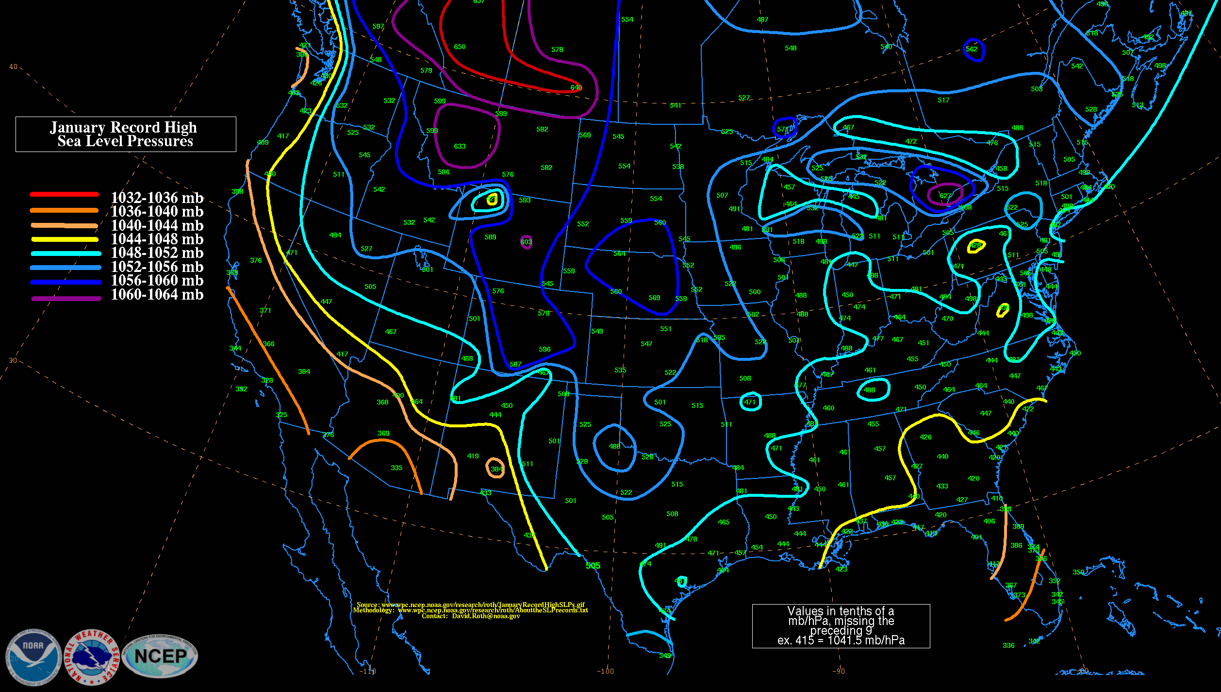
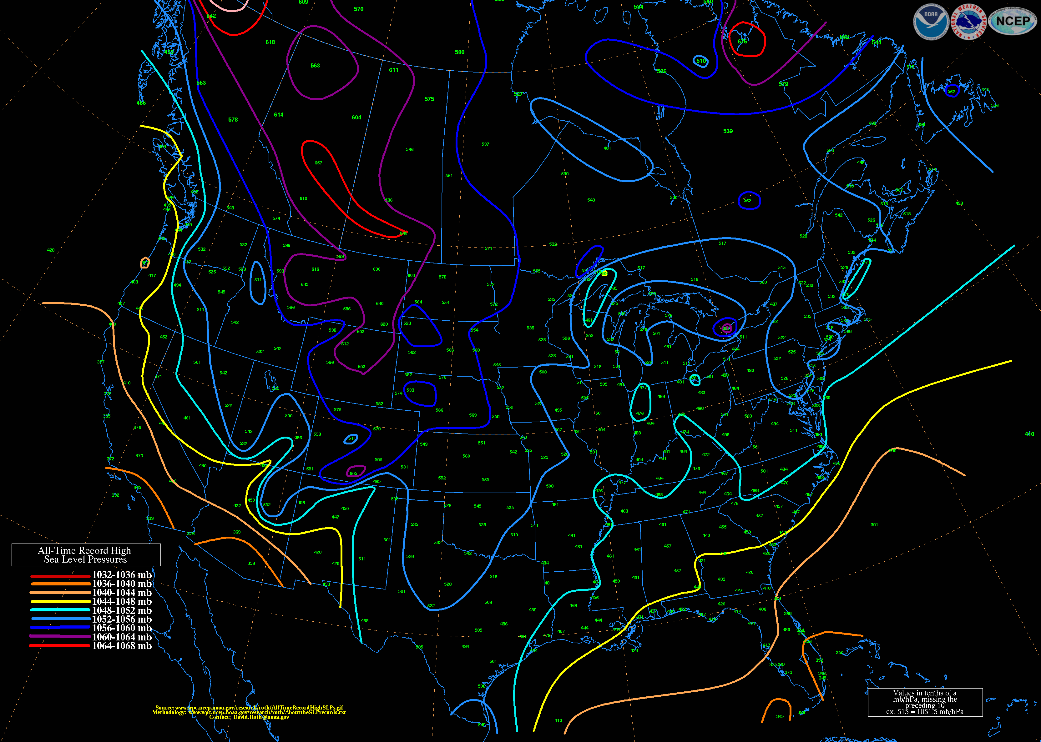
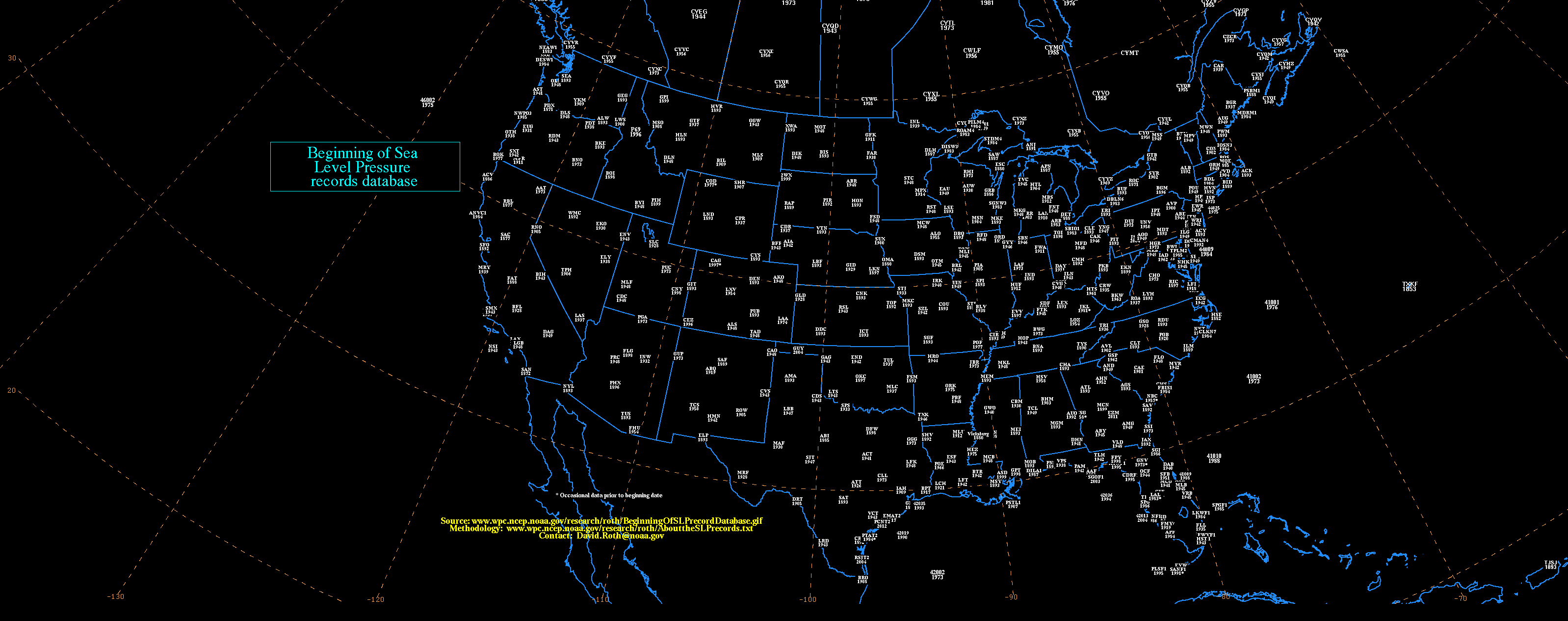
A few monthly SLP records appear to be within reach this week, especially as the core of high pressure moves across the Northern and Central Plains on Wednesday. Models are projecting SLP to peak above 1050 mb [about 31.01"] across a relatively large area. Weather Underground historian Chris Burt has a comprehensive site listing all-time high-pressure records for many U.S. cities, and NOAA's David Roth has produced maps (in millibars, or mb) depicting the highest January and highest all-time values at many U.S. locations, typically going back to the 1890s (see this map showing the period of record at each site). Among the spots to watch:
Rapid City, South Dakota
Jan. record: 1054.9 mb [31.15"]
All-time record: 1056.2 mb [31.19"]
Des Moines, Iowa
Jan. record: 1051.1 [31.04"]
All-time record: 1051.8 mb [31.06"]
Springfield, Missouri
Jan. and all-time record: 1050.8 mb [31.03"]
If the nation does notch any all-time SLP records this week, it won't be the first time this winter. On December 30, Washington's Seattle-Tacoma Airport reached the highest SLP in its 67-year weather history: 30.87" [1045.5 mb]. Several nearby stations also set impressive marks, as noted by the University of Washington's Cliff Mass in his weather blog.
Ahead of the latest cold surge, an Alberta clipper storm will deliver light to moderate snow across a broad swath of the Midwest into the mid-Atlantic. Toward the weekend, yet another strong zone of high pressure appears set to invade the central and eastern U.S., keeping the bulk of the country free of major winter storms for the time being.
A head-spinning temperature range
Even for an area accustomed to large daily swings in temperature, the Front Range of northeast Colorado experienced a startling surge of warmth on Monday, courtesy of downslope winds feeding into the Midwest clipper storm. After an overnight low of –5°F, Denver International Airport surged to a high of 55°F, making for a diurnal range of 60°F! January is renowned for rapid temperature variations along the east slopes of the Rockies, where downslope winds often scour out Arctic air. The largest 24-hour diurnal spread in U.S. history (103°F, from –54°F to 49°F) was recorded by an NWS cooperative observer in Loma, Montana, on January 14–15, 1972.
AMS Annual Meeting: Looking ahead to 2040
I'm in Phoenix this week, attending the 95th annual meeting of the American Meteorological Society. For anyone who loves weather and climate, the AMS meeting is a smorgasbord of excellent talks and special events. Each year the meeting opens with a weekend conference and career fair, aimed at college and university students, that's grown by leaps and bounds. There's also a free WeatherFest on Sunday afternoon that draws thousands of weather aficionados of all ages.
The main conference opened on Monday morning with a forward-looking Presidential Forum designed to get attendees pondering what the field of meteorology might look like in the year 2040 and what roles they can play. "In some ways, you might consider this meeting a gateway from the past into the future," said outgoing AMS president Bill Gail. Moderated by UCAR/NOAA postdoctoral research scientist and policy advisor Kim Klockow, the panel discussion included a keynote talk from NOAA administrator Kathryn Sullivan, followed by remarks from University of Nebraska graduate student Curtis Walker, Climate Central meteorologist Bernadette Woods Placky, and Mac Devine, who directs CloudFirst Innovation at IBM.

Figure 2. AMS Presidential Forum panelists (left to right) Kathryn Sullivan, NOAA; Kim Klockow, UCAR/NOAA; Curtis Walker, University of Nebraska–Lincoln; Bernadette Woods Placky, Climate Central; and Mac Devine, IBM. Photo credit: Bob Henson.
There's no telling exactly what technologies will be coming down the pike 25 years from now. Mobile phones were clunky, high-ticket items in 1990, as Sullivan observed, and Facebook and Twitter were years away from being born. However, the panelists agreed that weather and climate services can and must become more accessible and user-oriented than ever. I was especially struck by Curtis Walker's passion for improving road-weather prediction, given that thousands of Americans still die in weather-related highway accidents each year. It's a heartbreaking toll that we seldom truly ponder, and one that research and technology can go a great way toward reducing.

Figure 3. AMS attendees await the conference kickoff on Monday morning, January 5. Photo credit: Bob Henson.
Bob Henson
Most high-pressure records east of the Rockies occur during the winter months, as darkness and snow cover allow frigid, dense cold air masses to develop and surge southward. Many all-time pressure records across the plains were established during the memorable cold wave of late December 1983, which sent temperatures down to 9°F as far south as San Antonio and kept Omaha lodged below 0°F for more than a solid week. On December 24 of that year, sea level pressure [SLP] soared to 1064 mb [31.42"] at Miles City, Montana. That value remains the highest sea-level-adjusted pressure on record for the contiguous United States.
Figure 1. Sea level pressures near the peak of the December 1983 cold wave, as mapped by the North American Regional Reanalysis. Image credit: Greg Carbin, NOAA.
A few monthly SLP records appear to be within reach this week, especially as the core of high pressure moves across the Northern and Central Plains on Wednesday. Models are projecting SLP to peak above 1050 mb [about 31.01"] across a relatively large area. Weather Underground historian Chris Burt has a comprehensive site listing all-time high-pressure records for many U.S. cities, and NOAA's David Roth has produced maps (in millibars, or mb) depicting the highest January and highest all-time values at many U.S. locations, typically going back to the 1890s (see this map showing the period of record at each site). Among the spots to watch:
Rapid City, South Dakota
Jan. record: 1054.9 mb [31.15"]
All-time record: 1056.2 mb [31.19"]
Des Moines, Iowa
Jan. record: 1051.1 [31.04"]
All-time record: 1051.8 mb [31.06"]
Springfield, Missouri
Jan. and all-time record: 1050.8 mb [31.03"]
If the nation does notch any all-time SLP records this week, it won't be the first time this winter. On December 30, Washington's Seattle-Tacoma Airport reached the highest SLP in its 67-year weather history: 30.87" [1045.5 mb]. Several nearby stations also set impressive marks, as noted by the University of Washington's Cliff Mass in his weather blog.
Ahead of the latest cold surge, an Alberta clipper storm will deliver light to moderate snow across a broad swath of the Midwest into the mid-Atlantic. Toward the weekend, yet another strong zone of high pressure appears set to invade the central and eastern U.S., keeping the bulk of the country free of major winter storms for the time being.
A head-spinning temperature range
Even for an area accustomed to large daily swings in temperature, the Front Range of northeast Colorado experienced a startling surge of warmth on Monday, courtesy of downslope winds feeding into the Midwest clipper storm. After an overnight low of –5°F, Denver International Airport surged to a high of 55°F, making for a diurnal range of 60°F! January is renowned for rapid temperature variations along the east slopes of the Rockies, where downslope winds often scour out Arctic air. The largest 24-hour diurnal spread in U.S. history (103°F, from –54°F to 49°F) was recorded by an NWS cooperative observer in Loma, Montana, on January 14–15, 1972.
AMS Annual Meeting: Looking ahead to 2040
I'm in Phoenix this week, attending the 95th annual meeting of the American Meteorological Society. For anyone who loves weather and climate, the AMS meeting is a smorgasbord of excellent talks and special events. Each year the meeting opens with a weekend conference and career fair, aimed at college and university students, that's grown by leaps and bounds. There's also a free WeatherFest on Sunday afternoon that draws thousands of weather aficionados of all ages.
The main conference opened on Monday morning with a forward-looking Presidential Forum designed to get attendees pondering what the field of meteorology might look like in the year 2040 and what roles they can play. "In some ways, you might consider this meeting a gateway from the past into the future," said outgoing AMS president Bill Gail. Moderated by UCAR/NOAA postdoctoral research scientist and policy advisor Kim Klockow, the panel discussion included a keynote talk from NOAA administrator Kathryn Sullivan, followed by remarks from University of Nebraska graduate student Curtis Walker, Climate Central meteorologist Bernadette Woods Placky, and Mac Devine, who directs CloudFirst Innovation at IBM.
Figure 2. AMS Presidential Forum panelists (left to right) Kathryn Sullivan, NOAA; Kim Klockow, UCAR/NOAA; Curtis Walker, University of Nebraska–Lincoln; Bernadette Woods Placky, Climate Central; and Mac Devine, IBM. Photo credit: Bob Henson.
There's no telling exactly what technologies will be coming down the pike 25 years from now. Mobile phones were clunky, high-ticket items in 1990, as Sullivan observed, and Facebook and Twitter were years away from being born. However, the panelists agreed that weather and climate services can and must become more accessible and user-oriented than ever. I was especially struck by Curtis Walker's passion for improving road-weather prediction, given that thousands of Americans still die in weather-related highway accidents each year. It's a heartbreaking toll that we seldom truly ponder, and one that research and technology can go a great way toward reducing.
Figure 3. AMS attendees await the conference kickoff on Monday morning, January 5. Photo credit: Bob Henson.
Bob Henson
No comments:
Post a Comment